Aristotelis (municipality)
Appearance
Aristotelis
Αριστοτέλης | |
|---|---|
 | |
| Coordinates: 40°24′N 23°53′E / 40.400°N 23.883°E | |
| Country | Greece |
| Administrative region | Central Macedonia |
| Regional unit | Chalkidiki |
| Area | |
| • Municipality | 747.0 km2 (288.4 sq mi) |
| Population (2021)[1] | |
| • Municipality | 16,964 |
| • Density | 23/km2 (59/sq mi) |
| Time zone | UTC+2 (EET) |
| • Summer (DST) | UTC+3 (EEST) |
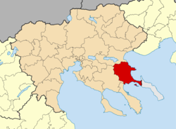
Aristotelis (Greek: Αριστοτέλης) is a municipality in the Chalkidiki regional unit, Central Macedonia, Greece. The seat of the municipality is the town Ierissos.[2] The municipality is named after the ancient philosopher Aristotle, whose birthplace, Stagira, lies within its bounds. The municipality also includes the area of the mining villages, known as Mademochoria. On the East, it borders the Monastic community of Mount Athos.
Municipality
[edit]The municipality Aristotelis was formed at the 2011 local government reform by the merger of the following 3 former municipalities, that became municipal units:[2]
The municipality has an area of 747.015 km2.[3]
References
[edit]- ^ "Αποτελέσματα Απογραφής Πληθυσμού - Κατοικιών 2021, Μόνιμος Πληθυσμός κατά οικισμό" [Results of the 2021 Population - Housing Census, Permanent population by settlement] (in Greek). Hellenic Statistical Authority. 29 March 2024.
- ^ a b "
Φ Ε Κ A 87/2010, Kallikratis reform law text" (in Greek). Government Gazette. - ^ "Population & housing census 2001 (incl. area and average elevation)" (PDF) (in Greek). National Statistical Service of Greece. Archived from the original (PDF) on 2015-09-21.
External links
[edit]![]() Media related to Aristotelis at Wikimedia Commons
Media related to Aristotelis at Wikimedia Commons


