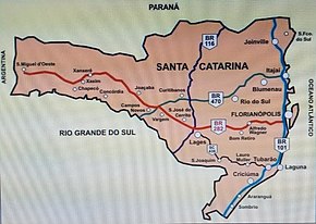
BR-282 (Brazil highway)
| BR-282 | |
|---|---|
 | |
| Route information | |
| Length | 680.6 km[1] (422.9 mi) |
| Major junctions | |
| east end | Florianópolis, Santa Catarina |
| west end | Paraíso, Santa Catarina |
| Location | |
| Country | Brazil |
| Highway system | |
BR-282 is a federal highway in the southern Brazilian state of Santa Catarina. The highway goes the entire length of the state from the state capital, Florianópolis on the Atlantic Ocean in the east, 680.6 km westward to the town of Paraíso on the border with Argentina.[1][2]
Economic importance
[edit]The highway is one of the main in the state of Santa Catarina, connecting the interior to the coastal ports. The areas around Chapecó and Concórdia, with population of Germanic descent, concentrate the largest production of pork in the country and are home to companies such as Sadia, Perdigão and Seara, which became the multinationals BRF and JBS. Although the highway reaches the border with Argentina, there is still no large movement of goods between countries in the region. [3][4][5]
Gallery
[edit]-
BR-282
-
BR-282 near Alfredo Wagner
-
BR-282 near Lages
-
BR-282 near Joaçaba
-
The Comandante Rosales International Bridge marks the end of the BR-282 on the border with Argentina.
References
[edit]- ^ a b "SNV 2015 Completo". dnit.gov.br (in Portuguese). Departamento Nacional de Infraestrutura de Transportes (DNIT) — Sistema Nacional de Viação. 2015-12-15. Archived from the original on 4 March 2016. Retrieved 28 February 2016.
- ^ "Infra-estrutura de transportes" (map). ibge.gov.br (in Portuguese). Brazilian Institute of Geography and Statistics (IBGE). 2005. Retrieved 28 February 2016.[permanent dead link]
- ^ REGIÃO SUL DO BRASIL É O MAIOR CENTRO PRODUTIVO DE PROTEÍNA ANIMAL DO MUNDO
- ^ PPM 2017: Rebanho bovino predomina no Centro-Oeste e Mato Grosso lidera entre os estados
- ^ PPM 2017: Rebanho bovino predomina no Centro-Oeste e Mato Grosso lidera entre os estados


