Cư Kuin district
Appearance
You can help expand this article with text translated from the corresponding article in Vietnamese. (March 2009) Click [show] for important translation instructions.
|
Cư Kuin district
Huyện Cư Kuin | |
|---|---|
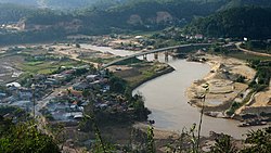
 Overlooking Đông Hòa Hiệp bridge | |
| Country | |
| Region | Central Highlands |
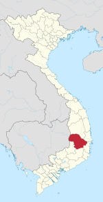
| Province | Đắk Lắk |
| Area | |
| • Total | 111.3 sq mi (288.3 km2) |
| Population (2004) | |
| • Total | 109,770 |
| Time zone | UTC+7 (Indochina Time) |
| Website | http://cukuin.net |
Cư Kuin is a district of Đắk Lắk province in the Central Highlands of Vietnam. The district was established in 2007. Its area is approximately 288.3 km², and its population is about 109,770 people.
Administration
[edit]Cư Kuin is divided into eight communes, including:
- Ea Ning
- Ea Tiêu
- Ea K'Tur
- Ea Bhôk
- Hòa Hiệp
- Dray Bhăng
- Ea Hu
- Cư Êwi


