
Es Castell
Es Castell | |
|---|---|
Municipality | |
 Cales Fonts | |
 Flag .svg) Coat of arms | |
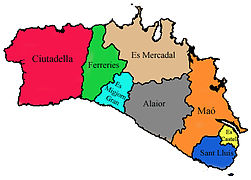
 Location of Es Castell in Menorca | |
 Es Castell Location in Menorca  Es Castell Es Castell (Balearic Islands)  Es Castell Es Castell (Spain) | |
| Coordinates: 39°52′49″N 4°17′27″E / 39.88028°N 4.29083°E | |
| Country | |
| Autonomous Community | |
| Province | Balearic Islands |
| Island | Menorca |
| Government | |
| • Mayor | Joana Escandell Salom (PP) |
| Area | |
| • Total | 11.6 km2 (4.5 sq mi) |
| Population (2018)[1] | |
| • Total | 7,348 |
| • Density | 630/km2 (1,600/sq mi) |
| Time zone | UTC+1 (CET) |
| • Summer (DST) | UTC+2 (CEST (GMT +2)) |
| Postal code | 07720 |
| Area code | +34 (Spain) + 971 (Baleares) |
| Website | Town Hall |
Es Castell (Catalan pronunciation: [əs kəsˈteʎ]) is a small municipality in eastern Menorca in the Balearic Islands, Spain. The town was founded in 1771 by British Col. Patrick Mackellar and was originally called Georgetown in honour of King George III; however, it takes its current name from the large fort nearby, known to the British as St. Philip's Castle. Col. Patrick MacKellar (Argyllshire 1717-1778) was the chief engineer of Menorca and his house today is known as Son Granot. Es Castell celebrates its Foundation Day on 1 June with 18th-century themed festivities, in which the Municipality itself, St. Philip's Castle Foundation, Son Granot and other institutions participate.
Gallery[edit]
-
 Municipalities of Menorca
 -
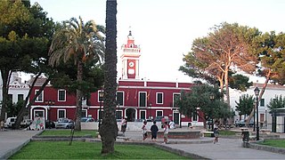 Es Castell town hall
 -
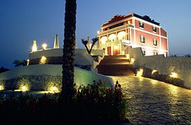 Son Granot
 -
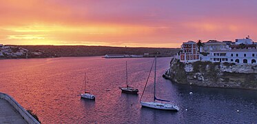 Sunrise at Cala Corb


References[edit]
- ^ Municipal Register of Spain 2018. National Statistics Institute.
External links[edit]
| International | |
|---|---|
| National | |
39°52′43″N 4°17′24″E / 39.87861°N 4.29000°E
This article about a location in the Balearic Islands is a stub. You can help Wikipedia by expanding it. |