Hato Corozal
Appearance
Hato Corozal | |
|---|---|
Municipality and town | |
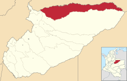
 Location of the municipality and town of Hato Corozal in the Casanare Department of Colombia. | |
| Country | |
| Region | Orinoquía Region |
| Department | Casanare Department |
| Area | |
| • Total | 56 km2 (22 sq mi) |
| Population (Census 2018[2]) | |
| • Total | 11,431 |
| • Density | 200/km2 (530/sq mi) |
| Time zone | UTC-5 (Colombia Standard Time) |
Hato Corozal (Spanish pronunciation: [ˈato koɾoˈsal]) is a town and municipality in the Department of Casanare, Colombia.
References
[edit]- ^ "Municipalities of Colombia". statoids. Retrieved 30 April 2020.
- ^ "Censo Nacional de Población y Vivienda 2018" (in Spanish). DANE. Archived from the original on 13 August 2020. Retrieved 30 April 2020.
3°11′N 73°45′W / 3.183°N 73.750°W

