
Kerama Islands
Native name: Kerama-shotō ( | |
|---|---|
 | |
 Map of the Kerama Islands | |
 Kerama Islands Location of the Kerama Islands  Kerama Islands Kerama Islands (Ryukyu Islands)  Kerama Islands Kerama Islands (Japan) | |
| Geography | |
| Location | Pacific Ocean |
| Coordinates | 26°12′00″N 127°19′59″E / 26.2°N 127.333°E |
| Archipelago | Okinawa Islands |
| Total islands | 36 |
| Major islands | Tokashiki Island, Zamami Island |
| Area | 35.97 km2 (13.89 sq mi) |
| Administration | |
Japan | |
| Prefecture | Okinawa Prefecture |
| Demographics | |
| Population | 1,625 (October 2010) |
| Pop. density | 45.2/km2 (117.1/sq mi) |
| Ethnic groups | Ryukyuan, Japanese |
| Official name | Keramashoto Coral Reef |
| Designated | 8 November 2005 |
| Reference no. | 1546[1] |
The Kerama Islands (
Geography
[edit]Four islands are inhabited: Tokashiki Island, Zamami Island, Aka Island, and Geruma Island.[2] The islands are administered as Tokashiki Village and Zamami Village within Shimajiri District.[3] The Kerama-shotō coral reef is a Ramsar Site.[4]
The archipelago consists of the following islands (-jima/-shima) – inhabited ones are highlighted in blue – and rocks (other suffixes, unnamed entries) with an area of at least 0.01 km2.[5][6]


Beaches
[edit]These are notable beaches of the Kerama Islands:
| Name | Island | Japanese name |
|---|---|---|
| Aharen Beach | Tokashiki Island | |
| Tokashiku Beach | Tokashiki Island | |
| Ama Beach | Zamami Island | |
| Furuzamami Beach | Zamami Island | |
| Kitahama Beach | Aka Island |
-
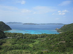
 Ama beach in Zamami island
 -
 Aharen Beach on Tokashiki Island
 -
 Tokashiku beach on Tokashiki Island
 -
 Tokashiku beach

.JPG)
.JPG)

Flora
[edit]The archipelago has several extensive coral reefs. Two of them were designated as Ramsar sites in November 2005: a 120-hectare area along the west coast of Tokashiki-jima and around Hanari-jima, and a 233-hectare area around Ijakaja-jima, Gahi-jima and Agenashiku-jima , i.e., between Aka Island and Zamami Island. These reefs are home to 248 different coral species, most notably of the Acropora genus.[9] On March 5, 2014, the waters and the islands were placed under protection as Kerama Shotō National Park.
-
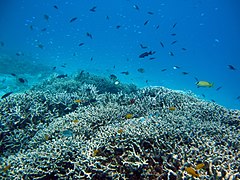 Coral reef, Aka island
 -
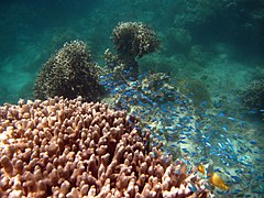 Coral reef, Aka island
 -
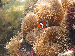 Clownfish, Aka island


Fauna
[edit]The islands of Aka, Fukaji, Geruma and Yakabi provide the sole natural habitat of the endangered Kerama deer (Cervus nippon keramae), thought to be an introduced population of the Japanese sika deer in the early 17th century that has since adapted to their island environment.[10]
History
[edit]The Kerama islands were historically part of the Ryukyu Kingdom (1429–1879), when islanders were employed as navigators on the kingdom’s trading vessels to China.[11]
During World War II and preliminary to the Battle of Okinawa, soldiers of the 77th Infantry Division landed in the Kerama Islands on March 26, 1945. Further landings followed, and the Kerama group was secured over the next five days. Kerama was used as a staging area for the assault on Okinawa. During the battle the first civilian mass suicides that later marked the Battle of Okinawa took place.[citation needed] The first US Navy ship to anchor in the harbor was USS Makin Island, a small "jeep" carrier.[citation needed]
Thereafter, the archipelago, like the rest of the Ryukyu Islands, was under US military administration before being returned to Japan in 1972.
The Kerama islands was the site of a true story about romance between two dogs who lived on neighboring islands that was made into the 1988 Japanese film I Want to See Marilyn (Marilyn ni Aitai).[12] It is now a popular beach and diving destination for visitors to Okinawa.
-
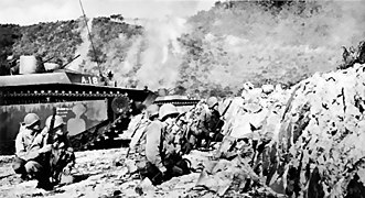 The 77th Infantry Division on Zamami Island during World War II

Transportation
[edit]The Kerama Islands are served by the Kerama Airport, located on Fukaji Island.[13] Regular ferries are also available from Naha to the three largest islands, Aka, Zamami, and Tokashiki. Ferries between the islands are also available, as are boat tours.
References
[edit]- ^ "Keramashoto Coral Reef". Ramsar Sites Information Service. Retrieved 25 April 2018.
- ^ Kerama Islands. Open Coast Travel.
- ^ Special Feature #1 : Seas of Okinawa -The Kerama Islands- Archived 2011-05-17 at the Wayback Machine, Okinawa Prefecture
- ^ "Ramsar Sites in Japan - Kerama-shoto Coral Reef" (PDF). Ministry of the Environment. Retrieved 24 March 2011.
- ^ "
沖縄 県 島 しょ別 面積 一覧 " (in Japanese). Präfektur Okinawa. 2013-11-13. Archived from the original on 2020-04-17. - ^ "
指定 離島 ・指定 離島 一覧 " (PDF). pref.okinawa.jp離島 関係 資料 (平成 28年 1月 ) (in Japanese).沖縄 県 企画 部 地域 ・離島 課 [Land and Islands Section, Planning Department, Okinawa Prefecture]. 2016-01-01. Retrieved 2016-08-03. - ^ vermutete Zuordnung: In der Quelle als シマ(
砂 白島北 ) ‚Insel (nördlich von Sunashiru-jima)‘ aufgeführt. Auf den amtlichen Karten ist an diesen Koordinaten eine unbenannte Insel mit der angegebenen Fläche. - ^ vermutete Zuordnung: In der Quelle als シマ(モカラク
島 北 ) ‚Insel (nördlich von Mokaraku-jima)‘ aufgeführt. Auf den amtlichen Karten ist an diesen Koordinaten eine unbenannte Insel mit der angegebenen Fläche. - ^ "Kerama-shoto Coral Reef" (PDF; 523 kB). Conservation and Wise Use of Rich and Diverse Wetlands: Ramsar Sites in Japan. Ministry of the Environment. 2008. p. 41. Retrieved 2012-11-29.
- ^ "Cervus nippon keramae". National Institute for Environmental Studies. Retrieved 2014-06-11.
- ^ "Kerama islands". Kerama islands. Retrieved 2016-06-10.
- ^ Marilyn Ni Aitai at IMDb
- ^ Map showing islands of Zamami Village Archived 2011-05-26 at the Wayback Machine
External links
[edit]| International | |
|---|---|
| National | |
| Other | |