Križevci
This article includes a list of general references, but it lacks sufficient corresponding inline citations. (August 2011) |
Križevci | |
|---|---|
| Grad Križevci Town of Križevci | |
Križevci | |
 Location of Križevci in Croatia | |
| Coordinates: 46°01′33″N 16°32′33″E / 46.02583°N 16.54250°E | |
| Country | |
| County | |
| Government | |
| • Mayor | Mario Rajn (Ind.) |
| Area | |
| • Town | 264.2 km2 (102.0 sq mi) |
| • Urban | 32.0 km2 (12.4 sq mi) |
| Elevation | 140 m (460 ft) |
| Population (2021)[2] | |
| • Town | 18,949 |
| • Density | 72/km2 (190/sq mi) |
| • Urban | 10,522 |
| • Urban density | 330/km2 (850/sq mi) |
| Time zone | UTC+1 (CET) |
| • Summer (DST) | UTC+2 (CEST) |
| Postal code | 48260 |
| Area code | 048 |
| Vehicle registration | KŽ |
| Website | krizevci |
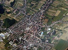
Križevci (Croatian: [krǐːʒeːʋtsi]; Latin: Crisium; Hungarian: Kőrös [ˈkøːrøʃ]; German: Kreutz [kʁɔʏts] ) is a town in northern Croatia with a total population of 21,122 and with 11,231 in the town itself (2011),[3] It is the oldest town in its county, the Koprivnica-Križevci County.
History
[edit]

The first mention of "Upper Križevac" was in 1193 by Béla III, when it was given the status of a Royal Borough[4] in 1252 by the ban (count) Stephan, and which was confirmed by King Béla IV a year later. "Lower Križevac" developed somewhat slower than its twin town: it became a free royal city in 1405, thanks to king Sigismund.
Bloody Sabor of Križevci (Croatian: Krvavi Sabor u Križevcima) refers to the assassination of the Croatian ban Stjepan Lacković and his followers at the orders of king Holy Roman Emperor Sigismund, on 27 February 1397.[5]
Križevac is the birthplace of the Catholic priest and martyr Saint Marko of Križevac, who died at the hands of Calvinists in Košice in 1619, and was subsequently canonized because of his martyrdom. His feast day is celebrated on September 7.
After centuries of separation, Empress Maria Theresa of Austria united Lower and Upper Križevac into "Križevci" in 1752 (the word Križevci is plural of Križevac). The town was attacked during the wars with the Turks, but regained its prominence in 1871 when the newly built railway passed through it connecting Budapest and Rijeka.
In the late 19th century and early 20th century, Križevci was the district capital of the Bjelovar-Križevci County in the Kingdom of Croatia-Slavonia.
These days, while the city has become a hub of entrepreneurship, it still enjoys many of the most valuable and ancient monuments in the county (both in the town itself and the wider region).
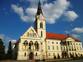
Križevci has nine churches (seven Roman Catholic, one Greek Catholic and one Serbian Orthodox), some of them dating back to the Middle Ages. In the oldest Gothic Church of Holy Cross in Križevci, there are important Baroque frescoes and a marble altar dating from the 18th century (by Francesco Robba). Also of artistic and cultural interest is the parish church of St. Anne from the 17th century.
Of particular note is the impressive and culturally significant Greek Catholic Cathedral of the Holy Trinity, the seat of the Eparchy of Križevci since 1789. The cathedral was designed by some of Zagreb's finest architects. Its facade was rebuilt by Bartol Felbinger in 1817; while an internal reconstruction was executed in the Gothic revival style by Hermann Bolle in 1892-97. The iconostasis and the frescoes are the work of several important Croatian painters, including Ivan Tišov, Celestin Medović and Bela Čikoš-Sesija.
Križevci Synagogue was built in 1895. It was robbed and gutted by the fascist government in 1941, and turned into a cultural center by the communist government after the end of World War II. It was renovated in 2014 and now mainly serves as a Tourist Information Center.
The town museum exhibits a rich archeological, ethnographic and cultural-historical collection.
Geography
[edit]Križevci is a town in the Koprivnica-Križevci County. Because of its close proximity to Zagreb (57 km), Križevci is becoming a "satellite suburb" of the national capital. It enjoys a central position in the region due to its close proximity to all the regional centers: Koprivnica (31 km), Bjelovar (33 km) and Varaždin (48 km). The town's importance has always depended on its status as a crossroads. It was known in antiquity and in the Middle Ages because of its location along one of the main caravan routes; in fact, there was a famous "King's Coloman Road" that passed through Križevci, connecting Pannonia and Dalmatia. In the more recent times it became a major transport hub: roads connecting Posavina and the region around Kalnik and Podravina were all already built in the 18th century; the railroad between Hungary and Zagreb, that goes through Koprivnica and Križevci (1870.), and to Bjelovar (1894). Today, the town remains an important center connecting Bjelovar and Koprivnica, and other major regional centers. Križevci is 140 m above sea-level, where the southern part of Kalnik begins.
Topographically, it lies on Pleistocene foundations, between swamped alluvial valleys of the brook Vrtlin from the east and the brook Koruska from the west. Relief, geological-petrografical structure, convenient climate and abundance of water, all contribute to the economic and demographic development of the town. The city has been affected by major demographic and economic regional changes, most notably due to increased industrialization and the consequent decline in agricultural production, and rural communities, with the population move to Križevci.
Climate
[edit]| Climate data for Križevci, Croatia (1971–2000, extremes 1961–2014) | |||||||||||||
|---|---|---|---|---|---|---|---|---|---|---|---|---|---|
| Month | Jan | Feb | Mar | Apr | May | Jun | Jul | Aug | Sep | Oct | Nov | Dec | Year |
| Record high °C (°F) | 16.8 (62.2) |
21.7 (71.1) |
25.2 (77.4) |
29.6 (85.3) |
32.7 (90.9) |
35.1 (95.2) |
37.6 (99.7) |
38.5 (101.3) |
33.5 (92.3) |
27.9 (82.2) |
23.9 (75.0) |
21.6 (70.9) |
38.5 (101.3) |
| Mean daily maximum °C (°F) | 2.9 (37.2) |
6.0 (42.8) |
11.2 (52.2) |
15.7 (60.3) |
20.8 (69.4) |
23.8 (74.8) |
25.9 (78.6) |
25.7 (78.3) |
21.5 (70.7) |
15.4 (59.7) |
8.3 (46.9) |
3.9 (39.0) |
15.1 (59.2) |
| Daily mean °C (°F) | −0.3 (31.5) |
1.7 (35.1) |
6.0 (42.8) |
10.2 (50.4) |
15.0 (59.0) |
18.1 (64.6) |
19.9 (67.8) |
19.2 (66.6) |
15.1 (59.2) |
9.8 (49.6) |
4.4 (39.9) |
0.8 (33.4) |
10.0 (50.0) |
| Mean daily minimum °C (°F) | −3.6 (25.5) |
−2.5 (27.5) |
0.9 (33.6) |
4.5 (40.1) |
9.0 (48.2) |
12.3 (54.1) |
13.8 (56.8) |
13.4 (56.1) |
9.8 (49.6) |
5.2 (41.4) |
0.8 (33.4) |
−2.3 (27.9) |
5.1 (41.2) |
| Record low °C (°F) | −25.5 (−13.9) |
−22.6 (−8.7) |
−18.7 (−1.7) |
−5 (23) |
−3 (27) |
0.5 (32.9) |
4.0 (39.2) |
2.4 (36.3) |
−2.0 (28.4) |
−7 (19) |
−17.2 (1.0) |
−21 (−6) |
−25.5 (−13.9) |
| Average precipitation mm (inches) | 39.1 (1.54) |
40.1 (1.58) |
46.3 (1.82) |
57.5 (2.26) |
75.2 (2.96) |
90.4 (3.56) |
76.0 (2.99) |
70.5 (2.78) |
75.5 (2.97) |
75.5 (2.97) |
79.0 (3.11) |
60.9 (2.40) |
785.9 (30.94) |
| Average precipitation days (≥ 0.1 mm) | 9.0 | 8.6 | 9.9 | 12.2 | 12.2 | 13.3 | 10.6 | 9.8 | 10.4 | 11.0 | 11.2 | 10.6 | 128.9 |
| Average snowy days (≥ 1.0 cm) | 11.2 | 8.9 | 2.7 | 0.1 | 0.0 | 0.0 | 0.0 | 0.0 | 0.0 | 0.0 | 3.0 | 7.1 | 33.0 |
| Average relative humidity (%) | 84.7 | 78.4 | 72.0 | 69.6 | 71.9 | 73.5 | 73.8 | 76.7 | 81.3 | 83.9 | 85.8 | 87.0 | 78.2 |
| Mean monthly sunshine hours | 58.9 | 101.7 | 142.6 | 171.0 | 232.5 | 237.0 | 282.1 | 260.4 | 192.0 | 127.1 | 66.0 | 49.6 | 1,920.9 |
| Percent possible sunshine | 24 | 39 | 43 | 46 | 54 | 55 | 64 | 64 | 56 | 44 | 30 | 25 | 48 |
| Source: Croatian Meteorological and Hydrological Service[6][7] | |||||||||||||
Demographics
[edit]According to the 2011 census, Croats form an absolute majority at 96.6% with Serbs making up for 2.1% of the population.[8]
The list of settlements in the administrative area of Križevci is:[3]
- Apatovec, population 350
- Beketinec, population 38
- Bojnikovec, population 219
- Bukovje Križevačko, population 316
- Carevdar, population 438
- Cubinec, population 546
- Čabraji, population 153
- Dijankovec, population 188
- Doljanec, population 53
- Donja Brčkovčina, population 165
- Donja Glogovnica, population 129
- Donji Dubovec, population 34
- Đurđic, population 267
- Erdovec, population 207
- Gornja Brčkovčina, population 160
- Gornja Glogovnica, population 115
- Gornji Dubovec, population 8
- Gračina, population 209
- Ivanec Križevački, population 308
- Jarčani, population 97
- Karane, population 229
- Kloštar Vojakovački, population 366
- Kostadinovac, population 14
- Križevci, population 11,231
- Kučari, population 31
- Kunđevec, population 11
- Lemeš, population 111
- Lemeš Križevački, population 183
- Majurec, population 423
- Male Sesvete, population 46
- Mali Carevdar, population 19
- Mali Potočec, population 169
- Mali Raven, population 15
- Marinovec, population 103
- Mičijevac, population 69
- Novaki Ravenski, population 178
- Novi Bošnjani, population 81
- Novi Đurđic, population 130
- Osijek Vojakovački, population 205
- Pavlovec Ravenski, population 101
- Pesek, population 271
- Pobrđani Vojakovački, population 35
- Podgajec, population 21
- Poljana Križevačka, population 396
- Povelić, population 86
- Prikraj Križevački, population 194
- Ruševac, population 182
- Srednji Dubovec, population 93
- Stara Ves Ravenska, population 31
- Stari Bošnjani, population 105
- Sveta Helena, population 309
- Sveti Martin, population 91
- Špiranec, population 151
- Većeslavec, population 143
- Velike Sesvete, population 87
- Veliki Potočec, population 399
- Veliki Raven, population 219
- Vojakovac, population 234
- Vujići Vojakovački, population 57
- Žibrinovec, population 113
| population | 12438 | 12769 | 13752 | 15798 | 17709 | 19108 | 18319 | 19230 | 19729 | 20575 | 21793 | 22534 | 22772 | 22676 | 22324 | 21122 | 18949 |
| 1857 | 1869 | 1880 | 1890 | 1900 | 1910 | 1921 | 1931 | 1948 | 1953 | 1961 | 1971 | 1981 | 1991 | 2001 | 2011 | 2021 |
Education
[edit]Križevci is home to the Križevci College of Agriculture,[9] founded in 1860 as the Royal Agriculture and Forestry College.[10]
Culture
[edit]Križevci is home to a monument to the 37 people from the town who died in the Croatian War of Independence entitled the Mother of the Fallen Hero.[11]
Notable people
[edit]- Dubravko Detoni - composer
- Ivan Andrija Makar - 17th century Croatian and Habsburg soldier
- Julije Drohobeczky - bishop
- Sidonija Rubido - first Croatian opera singer
- Branko Hrg - politician
- Dora Kalaus - handball player
- Larissa Kalaus
- Marcel Kiepach - inventor
- Marko Krizin - catholic saint
- Franjo Marković - writer
- Antun Nemčić - writer
- Dragutin Novak
- Vanessa Radman
- Alfred Švarc
- Marko Tomas - basketball player
- Ljudevit Vukotinović
- Branko Zorko
- Drago Grdenić
- Antonio Radić (born 1987), known for his YouTube chess channel 'agadmator'.[12]
- Magda Logomer, herbalist.
See also
[edit]References
[edit]- ^ Register of spatial units of the State Geodetic Administration of the Republic of Croatia. Wikidata Q119585703.
- ^ "Population by Age and Sex, by Settlements" (xlsx). Census of Population, Households and Dwellings in 2021. Zagreb: Croatian Bureau of Statistics. 2022.
- ^ a b "Population by Age and Sex, by Settlements, 2011 Census: Križevci". Census of Population, Households and Dwellings 2011. Zagreb: Croatian Bureau of Statistics. December 2012.
- ^ Križevci.eu - history / golden bull
- ^ Križevci Bloody Assembly Archived 2014-03-17 at the Wayback Machine krizevci.eu
- ^ "Križevci Climate Normals" (PDF). Croatian Meteorological and Hydrological Service. Retrieved 3 December 2015.
- ^ "Mjesečne vrijednosti za Križevci u razdoblju1961−2014" (in Croatian). Croatian Meteorological and Hydrological Service. Retrieved 3 December 2015.
- ^ "Population by Ethnicity, by Towns/Municipalities, 2011 Census: County of Koprivnica-Križevci". Census of Population, Households and Dwellings 2011. Zagreb: Croatian Bureau of Statistics. December 2012.
- ^ Križevci College of Agriculture Križevci. Accessed: April 13, 2013.
- ^ Husinec, Renata, and Dejan Marenčić. n.d. "Križevci College of Agriculture." Archived December 29, 2009, at the Wayback Machine Accessed: April 13, 2013.
- ^ Otkrivena 'Majka poginulog junaka'
- ^ Belani, Hrvoje (21 February 2018). "Antonio Radić: 'Svojim YouTube kanalom mogu svakoga zainteresirati za šah'" (in Croatian). Retrieved 17 November 2019.


