Los Pedroches
Appearance
Los Pedroches
Los Pedroches | |
|---|---|
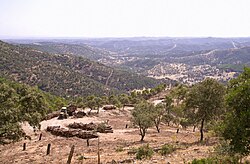
 Landscape of Los Pedroches at Los Muros, near Cardeña. | |
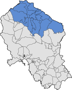
 Location of Los Pedroches in the province of Córdoba | |
| Country | Spain |
| Region | Andalusia |
| Area | |
| • Total | 3,500 ha (8,600 acres) |
| Dimensions | |
| • Length | 115 km (71 mi) |
| • Width | 60 km (40 mi) |
| Elevation | 650 m (2,130 ft) |

Los Pedroches is a natural region and comarca in Córdoba Province, Andalusia, southern Spain. It is located in the Sierra Morena area at the northern end of the province.[2] The main town is Pozoblanco.
The climate of the comarca is continental. It is the northernmost Andalusian territory. The name of the present-day official comarca is Los Pedroches.[3]
The kūra of Fahs al‐Ballūt quite coincided with Los Pedroches.[4]
Municipalities
[edit]- Alcaracejos
- Añora
- Belalcázar
- Cardeña
- Conquista
- Dos Torres
- El Guijo
- El Viso
- Fuente la Lancha
- Hinojosa del Duque
- Pedroche
- Pozoblanco
- Santa Eufemia
- Torrecampo
- Villanueva del Duque
- Villaralto
- Villanueva de Córdoba
See also
[edit]References
[edit]- ^ Mancomunidad de Municipios de los Pedroches
- ^ Cordobapedia - Los Pedroches
- ^ "El mal llamado ´valle de los pedroches´". Diario Córdoba (in Spanish). 2008-08-08. Retrieved 2024-11-07.
- ^ Rosique Rodríguez, Mª Victoria (2015). "EL POBLAMIENTO ISLÁMICO EN LA KURA DE FAHS AL‐BALLŪT: UNA APROXIMACIÓN ARQUEOLÓGICA / THE ISLAMIC SETTLEMENT IN THE KURA OF FAHS AL‐BALLŪT: AN ARCHAEOLOGICAL APPROACH". Anahgramas (in Spanish): 114–151. doi:10.21071/ahgm.v0i2.4118. ISSN 2444-3123. Retrieved 29 November 2023.
