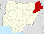
Mobbar
Mobbar | |
|---|---|
 | |
| Country | |
| State | Borno State |
| Government | |
| • Executive Chairman:
| Hon. Mohammed M Aji (M Gas Mobbar)
Zanna Gangaran Zanna
|
| Time zone | UTC+1 (WAT) |
 | |
Mobbar is a Local Government Area of Borno State, Nigeria. Its headquarters are in the town of Damasak.
It has an area of 2,790 km2 and a population of 116,654 at the 2006 census.
The postal code of the area is 602.[1]
It is one of the sixteen LGAs that constitute the Borno Emirate, a traditional state located in Borno State, Nigeria.[2]
Business
[edit]Mobbar shares boundaries with the republic of Niger, as a result most agricultural commodities such as fish, pepper and tomato are exported through her border.
Tourism: The san-san dunes is situated in the outskirts of the local government which will be an amazing site of tourism if further developed.
Politics
[edit]Mobbar is a birthplace to prominent leaders and politicians among the notable ones are; former Governor of Borno State late Alh. Mohammed Goni, former military Administrator Late. Brig.Gen. Abba Kyari rtd, Sen. Abubakar Kyari, former senator representing Borno North senatorial district the current Minister of Agriculture and Food Security Federal Republic of Nigeria, Amb. Mohammed M Aji (M-gas) Borno State Ambassador to Niger Republic, former two term care-taker Chairman, Retired Counci Secretary, and Current Executive Chairman. It is also a home to political gladiators such as Alh. Aliyu Kyari, Alh. Gambo Lawan, Umar Kareto, Mohammed M Aji (M Gas Mobbar) and many more who have tirelessly worked to transform Mobbar, Borno and Nigeria at large.
Climate /Geography
[edit]The Mobbar Local Government Area (LGA) has a total area of 2790 square kilometers, an average temperature of 33 degrees Celsius, two distinct seasons—the dry and the rainy—and an estimated average wind speed of 11 km/h.[3]
References
[edit]- ^ "Post Offices- with map of LGA". NIPOST. Archived from the original on 2012-11-26. Retrieved 2009-10-20.
- ^ Nigeria (2000). Nigeria: a people united, a future assured. Vol. 2, State Surveys (Millennium ed.). Abuja, Nigeria: Federal Ministry of Information. p. 106. ISBN 9780104089.
- ^ "Mobbar Local Government Area". www.manpower.com.ng. Retrieved 2024-08-09.

