
Mount Iyogatake
| Mount Iyogatake | |
|---|---|
| Iyogatake | |
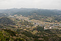
 View of southern slope of Mount Iyogatake, Minamibōsō, Chiba | |
| Highest point | |
| Elevation | 336.6 m (1,104 ft) |
| Coordinates | 35°6′26″N 139°54′50″E / 35.10722°N 139.91389°E |
| Naming | |
| Language of name | Japanese |
| Pronunciation | [ijoɡatake] |
| Geography | |
 Mount Iyogatake Chiba Prefecture, Honshu, Japan | |
| Parent range | Bōsō Hill Range |
| Climbing | |
| Easiest route | Hike |
Mount Iyogatake (
Mount Iyogatake is one of the few mountains in the Bōsō Hill Range with steep rock cliff.[2] It can be easily climbed within 40 minutes. The entrance to the path of the mountain is between Heguri Elementary School and the Heguri Tenjin Shrine. Mount Iyogatake offers a clear view of the other mountains of the Bōsō Hill Range and Tokyo Bay,[3] and on clear days Mount Fuji and the Izu Islands are also visible.[4]
Mount Iyogatake and the Heguri Tenjin Shrine are associated with a legend of a tengu, a supernatural creature found in Japanese folklore.[5]
Transportation[edit]
The path to the peak of Mount Iyogatake is accessible by bus from the JR East Uchibō Line Iwai Station in Minamibōsō.
Gallery[edit]
-
 View of Mount Iyogatake
 -
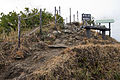 Summit of Mount Iyogatake
 -
 Summit of Mount Iyogatake


References[edit]
- ^
伊予ヶ岳 Archived 2012-04-26 at the Wayback Machine(in Japanese) - ^
南 房総 市 富山 海 と山 (in Japanese) - ^
伊予ケ岳 (南 房総 市 ) Archived 2012-04-26 at the Wayback Machine(in Japanese) - ^
伊予ヶ岳 いよがたけ(in Japanese) - ^
伊予ケ岳 の天狗 (in Japanese)