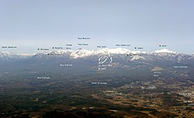
Mount Nasu
Appearance
This article needs additional citations for verification. (February 2022) |
| Mount Nasu | |
|---|---|
 Nasu Mountains | |
| Highest point | |
| Peak | Sanbonyari Peak |
| Elevation | 1,916.9 m (6,289 ft)[1] |
| Listing | Mountains of Japan |
| Coordinates | 37°09′N 139°57′E / 37.150°N 139.950°E |
| Naming | |
| Language of name | Japanese |
| Geography | |
On the border of Nasushiohara and Nasu of Tochigi Prefecture, Nishigō, Nishishirakawa of Fukushima Prefecture, Japan | |
| Parent range | Ōu Mountains |
| Geology | |
| Mountain type | Complex volcano |
| Last eruption | November 1963[2] |
Mount Nasu (
Major peaks
[edit]Mount Nasu has the following major peaks:
- Sanbonyari Peak – 1916.9 m
- Chausu Peak – 1915 m
- Asahi Peak – 1896 m
- Minamigatsusan – 1776 m
- Kuro-oya Peak – 1589 m
These peaks are known collectively as Nasu Five Peaks (
Climate
[edit]| Climate data for Mount Nasu (1991−2020 normals, extremes 1976−present) | |||||||||||||
|---|---|---|---|---|---|---|---|---|---|---|---|---|---|
| Month | Jan | Feb | Mar | Apr | May | Jun | Jul | Aug | Sep | Oct | Nov | Dec | Year |
| Record high °C (°F) | 12.7 (54.9) |
16.8 (62.2) |
21.1 (70.0) |
26.8 (80.2) |
29.6 (85.3) |
30.3 (86.5) |
31.8 (89.2) |
32.2 (90.0) |
29.5 (85.1) |
24.6 (76.3) |
20.0 (68.0) |
17.4 (63.3) |
32.2 (90.0) |
| Mean daily maximum °C (°F) | 1.9 (35.4) |
2.7 (36.9) |
6.8 (44.2) |
13.0 (55.4) |
18.2 (64.8) |
20.7 (69.3) |
24.3 (75.7) |
25.4 (77.7) |
21.4 (70.5) |
16.1 (61.0) |
10.9 (51.6) |
5.1 (41.2) |
13.9 (57.0) |
| Daily mean °C (°F) | −1.7 (28.9) |
−1.3 (29.7) |
2.0 (35.6) |
7.8 (46.0) |
13.0 (55.4) |
16.4 (61.5) |
20.2 (68.4) |
21.0 (69.8) |
17.3 (63.1) |
11.8 (53.2) |
6.4 (43.5) |
1.1 (34.0) |
9.5 (49.1) |
| Mean daily minimum °C (°F) | −5.3 (22.5) |
−5.3 (22.5) |
−2.4 (27.7) |
2.6 (36.7) |
7.7 (45.9) |
12.3 (54.1) |
16.7 (62.1) |
17.5 (63.5) |
13.8 (56.8) |
7.7 (45.9) |
2.0 (35.6) |
−2.6 (27.3) |
5.4 (41.7) |
| Record low °C (°F) | −11.7 (10.9) |
−12.1 (10.2) |
−10.4 (13.3) |
−6.0 (21.2) |
−2.3 (27.9) |
3.6 (38.5) |
8.7 (47.7) |
8.9 (48.0) |
3.2 (37.8) |
−1.2 (29.8) |
−6.1 (21.0) |
−10.2 (13.6) |
−12.1 (10.2) |
| Average precipitation mm (inches) | 52.6 (2.07) |
42.8 (1.69) |
101.6 (4.00) |
139.6 (5.50) |
180.8 (7.12) |
220.5 (8.68) |
305.7 (12.04) |
303.9 (11.96) |
305.3 (12.02) |
212.6 (8.37) |
89.2 (3.51) |
60.1 (2.37) |
2,014.7 (79.33) |
| Average snowfall cm (inches) | 103 (41) |
79 (31) |
45 (18) |
7 (2.8) |
0 (0) |
0 (0) |
0 (0) |
0 (0) |
0 (0) |
0 (0) |
4 (1.6) |
55 (22) |
293 (116.4) |
| Average precipitation days (≥ 1.0 mm) | 9.1 | 8.3 | 10.4 | 11.3 | 12.1 | 15.9 | 18.3 | 17.0 | 14.8 | 11.5 | 8.3 | 9.1 | 146.1 |
| Average snowy days (≥ 1 cm) | 11.5 | 8.8 | 5.5 | 0.6 | 0 | 0 | 0 | 0 | 0 | 0 | 0.4 | 5.9 | 32.7 |
| Mean monthly sunshine hours | 131.0 | 129.0 | 156.4 | 170.4 | 169.1 | 108.8 | 98.7 | 115.3 | 98.9 | 115.1 | 130.1 | 132.6 | 1,555.2 |
| Source 1: JMA[3] | |||||||||||||
| Source 2: JMA[4] | |||||||||||||
Eruption
[edit]It is estimated that Mount Nasu started erupting 600 thousand years ago. The eruption started from the north end of the mountain range, at Kashi-Asahi Peak. Only Chausu Peak is active today.
Access
[edit]- Nasu Sancho Station of Nasu Ropeway
- Sandogoya Onsen Bus Stop of Kanto Transportation
Gallery
[edit]-
Chausu lava dome and Asahi Peak
-
Chausu lava dome and fumes
-
Asahi Peak
-
West view from Sanbonyari Peak
-
Sanbonyari Peak and snow in summer
-
At the Sanbonyari Peak
-
Topographic map
-
To Asahi Peak
References
[edit]- ^ "Topographic map of Mount Nasu". opentopomap.org. Retrieved 2023-06-12.
- ^ "Nasudake". Global Volcanism Program. Smithsonian Institution. Retrieved 2021-06-24.
- ^
観測 史上 1~10位 の値 (年間 を通 じての値 ). JMA. Retrieved February 18, 2022. - ^
気象庁 /平年 値 (年 ・月 ごとの値 ). JMA. Retrieved February 18, 2022.
External links
[edit]Wikimedia Commons has media related to Mount Nasu.
- Nasudake – Japan Meteorological Agency (in Japanese)
- "Nasudake: National catalogue of the active volcanoes in Japan" (PDF). – Japan Meteorological Agency
- Nasudake – Geological Survey of Japan


