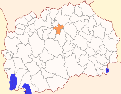
Petrovec Municipality
Appearance
Petrovec Municipality
Општина Петровец | |
|---|---|
Rural municipality | |
 | |
| Country | |
| Region | |
| Municipal seat | Petrovec |
| Government | |
| • Mayor | Borče Mitevski (VMRO-DPMNE) |
| Area | |
| • Total | 201.93 km2 (77.97 sq mi) |
| Population | |
| • Total | 9,150 |
| • Density | 40.88/km2 (105.9/sq mi) |
| Time zone | UTC+1 (CET) |
| Area code | 031 |
| car plates | SK |
| Website | http://www.opstina-petrovec.gov.mk |
Petrovec Municipality (Macedonian: Петровец) is a municipality in northern North Macedonia, near the capital Skopje. Petrovec is also the name of the village where the municipal seat is found. It is located in the Skopje Statistical Region.
Skopje International Airport is located in the Petrovec municipality.
Geography
[edit]The municipality borders with Studeničani Municipality and Zelenikovo Municipality to the west, Ilinden Municipality and Kumanovo Municipality to the north, Sveti Nikole Municipality to the east, and Veles Municipality to the south.
Demographics
[edit]According to the 2021 North Macedonia census, Petrovec Municipality has 9,150 residents.[1] Ethnic groups in the municipality:
| 2002 | 2021 | |||
| Number | % | Number | % | |
| TOTAL | 8,255 | 100 | 9,150 | 100 |
| Macedonians | 4,246 | 51,44 | 4,609 | 50.37 |
| Bosniaks | 1,442 | 17.47 | 1,701 | 18.59 |
| Albanians | 1,887 | 22.86 | 1,676 | 18.32 |
| Serbs | 415 | 5.03 | 327 | 3.57 |
| Turks | 75 | 0.91 | 116 | 1.27 |
| Roma | 134 | 1.62 | 54 | 0.54 |
| Vlachs | 2 | 0.02 | ||
| Other / Undeclared / Unknown | 56 | 0.67 | 65 | 0.71 |
| Persons for whom data are taken from administrative sources | 600 | 6.56 | ||

| Demographics of Petrovec Municipality | ||
|---|---|---|
| Census year | Population | |
| 1994 | 8,123 | |
| 2002 | 8,255 | |
| 2021 | 9,150 | |
References
[edit]- ^ "Попис на населението, домаќинствата и становите во Република Северна Македонија, 2021 - прв сет на податоци" (PDF). stat.gov.mk. Retrieved 22 July 2022.

