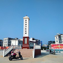
Qintang District
Appearance
Qintang
覃塘 | |
|---|---|
 | |
| Coordinates: 23°07′37″N 109°27′11″E / 23.127°N 109.453°E | |
| Country | China |
| Autonomous region | Guangxi |
| Prefecture-level city | Guigang |
| District seat | Qintang Subdistrict |
| Area | |
| • Total | 1,502 km2 (580 sq mi) |
| Population (2020) | |
| • Total | 423,747 |
| • Density | 280/km2 (730/sq mi) |
| Time zone | UTC+8 (China Standard) |
| Postal code | 537100 |
Qintang District (Chinese: 覃塘
Population
[edit]According to census 2020, Qintang District has a population of 423,747.[1]
Administrative divisions
[edit]Qintang District is divided into 1 subdistrict, 7 towns and 2 townships:[2]
- subdistrict
- Qintang 覃塘
街道
- towns
- Donglong 东龙镇
- Sanli
三 里 镇 - Huanglian
黄 练镇 - Shika
石 卡镇 - Wuli
五 里 镇 - Zhangmu
樟 木 镇 - Menggong
蒙 公 镇
- townships
- Shanbei
山北 乡 - Daling
大 岭乡
References
[edit]- ^ "
中國 : 广西壮 族 自治 区 (地 级行政 、县级行政 区 ) -人口 统计,图表和地 图". www.citypopulation.de. Archived from the original on 2023-08-19. Retrieved 2023-08-19. - ^ 2023
年 统计用 区 划代码和城 乡划分 代 码:覃塘区 (in Simplified Chinese). National Bureau of Statistics of China.

