
Scafells
| Scafells | |
|---|---|
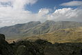
 View of the Scafells from Wastwater | |
| Highest point | |
| Elevation | max. 978 m (3,209 ft) at Scafell Pike |
| Coordinates | 54°28′16″N 3°08′38″W / 54.471°N 3.144°W |
| Geography | |
 Scafells Cumbria, England  Scafells Scafells (England)  Scafells Scafells (the United Kingdom) | |
| Parent range | Cumbrian Mountains |
| Geology | |
| Age of rock | - |
| Mountain type | Caldera |
| Last eruption | +400 MYA |
The Scafells, or Scafell Massif,[1] are a range of fells in the Cumbrian Mountains of England, made up of the remains of a caldera volcano. Fells in the range include Broad Crag, Ill Crag, Scafell, and Scafell Pike, England's tallest mountain. Great End, Lingmell and Slight Side are also usually included within the definition. These hills form part of the Southern Fells.

Geology
[edit]Geologically, parts of the Scafell massif are the remnants of a volcano that erupted in the Ordovician period over 400 million years ago. This volcano, geologically described as a caldera and an "inverse stratovolcano", as well as all other volcanoes of the Lake District, are long since extinct.[2]
The volcano is an example of a piecemeal caldera whose collapse, in contrast with a wholesale piston-like subsidence, occurred in a piece-by-piece fashion along faults and whose measurements suggest formation from an eruption of a VEI-7 magnitude, comparable to the Minoan eruption at Santorini in the Greek Aegean in c. 1600 BCE. The Scafell dacite, between Little Narrowcove and Aaron Crags, is a lava dome formed during the last stages of volcanic activity at Scafell massif.[2]
English Munros
[edit]An English Munro (or Furth) is a mountain summit that exceeds 3,000 feet (914.4 m) and has a prominence of more than 30 metres (98 feet). In England there are six peaks that meet that criteria and four of those are part of the Scafell Massif.[a]
| Peak | Area | Height (m) |
Prominence (m) |
OSI Grid Reference |
Highest Class |
|
|---|---|---|---|---|---|---|
| Scafell Pike‡ | Scafell Massif | 978 | 912 | NY215072 | P600 | |
| Sca Fell | Scafell Massif | 964 | 133 | NY207065 | Hewitt | |
| Helvellyn‡ | Helvellyn range | 950 | 712 | NY342151 | P600 | |
| Ill Crag | Scafell Massif | 935 | 57 | NY223073 | Hewitt | |
| Broad Crag | Scafell Massif | 934 | 52 | NY218075 | Hewitt | |
| Skiddaw‡ | Northern Fells | 931 | 709 | NY260290 | P600 |
(‡) Have the prominence of over 150 metres (492 ft) to qualify as a "Real Munro".
Accident black spots
[edit]Scafell and Scafell Pike
[edit]
The summit of Scafell (964 m) is only 14 m lower than Scafell Pike (978 m); it can sometimes appear to be higher because of its precipitous topography.
The traverse between England's two highest summit's via Mickledore col requires considerable care and caution:
- The route via Broad Stand is best avoided because it is dangerous.
- There is a safer but longer route available via Foxes Tarn.
. . ."Broad Stand is an extremely dangerous area which has unfortunately seen a number of fatalities.[3]
Gallery
[edit]-
 Scafell massif from Bowfell

References
[edit]- ^ Gannon, Paul (April 2009). Rock Trails Lakeland - A Hillwalker's Guide to the Geology & Scenery. Pesda Press. ISBN 9781906095154. Retrieved 29 April 2021.
- ^ a b Geology of England and Wales, pp118ff
- ^ *"Broad Stand – There is no easy route direct from Scafell to Scafell Pike!". Wasdale Mountain Rescue Team. Retrieved 1 December 2023.
Notes
[edit]- ^ In Scotland there are 442 peaks that meet that criteria. See Lists of mountains and hills in the British Isles > Murdos.