Seabrook, South Carolina
Seabrook | |
|---|---|
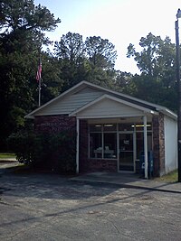
 Current Post office in Seabrook, South Carolina | |
 | |
| Country | United States |
| State | South Carolina |
| County | Beaufort |
| Area | |
| • Total | 6.53 sq mi (16.92 km2) |
| • Land | 5.50 sq mi (14.25 km2) |
| • Water | 1.03 sq mi (2.66 km2) |
| Elevation | 17 ft (5 m) |
| Population | |
| • Total | 1,255 |
| • Density | 228.06/sq mi (88.05/km2) |
| ZIP codes | 29940 |
| Area code(s) | 843, 854 |
| FIPS code | 45-64690 |

Seabrook is an unincorporated community and census-designated place (CDP) located in Beaufort County, South Carolina, United States. It was first listed as a CDP in the 2020 census with a population of 1,255.[3]
Situated in northern part of the county along the Whale Branch River, Seabrook was founded in the late 18th century as a collection of plantations became established in the area. In the late 19th century, Seabrook became a stop on the Port Royal and Augusta Railway and featured a small, but bustling downtown area that had a federal Post Office, a general store, a gas station, and a train station. The local economy was driven by the nearby farmland. The village's old economy and markets have since yielded to development in Beaufort, though the Post Office remains to serve the village's remaining inhabitants. In the past ten years, three new public schools have opened in the Seabrook area to serve area students, including Whale Branch Early College High School.
The McLeod Farmstead was listed on the National Register of Historic Places in 1997.[4]
Demographics
[edit]| Census | Pop. | Note | %± |
|---|---|---|---|
| 2020 | 1,255 | — | |
| U.S. decennial census[5] 2020[6][2] | |||
2020 census
[edit]| Race / Ethnicity (NH = Non-Hispanic) | Pop 2020[6] | % 2020 |
|---|---|---|
| White alone (NH) | 395 | 31.47% |
| Black or African American alone (NH) | 782 | 62.31% |
| Native American or Alaska Native alone (NH) | 7 | 0.56% |
| Asian alone (NH) | 7 | 0.56% |
| Pacific Islander alone (NH) | 0 | 0.00% |
| Other race alone (NH) | 0 | 0.00% |
| Mixed race or Multiracial (NH) | 19 | 1.51% |
| Hispanic or Latino (any race) | 45 | 3.59% |
| Total | 1,255 | 100.00% |
References
[edit]- ^ "ArcGIS REST Services Directory". United States Census Bureau. Retrieved October 15, 2022.
- ^ a b "Census Population API". United States Census Bureau. Retrieved October 15, 2022.
- ^ "Seabrook CDP, South Carolina". United States Census Bureau. Retrieved April 7, 2022.
- ^ "National Register Information System". National Register of Historic Places. National Park Service. July 9, 2010.
- ^ "Decennial Census of Population and Housing by Decades". US Census Bureau.
- ^ a b "P2 Hispanic or Latino, and Not Hispanic or Latino by Race – 2020: DEC Redistricting Data (PL 94-171) – Seabrook CDP, South Carolina". United States Census Bureau.
Sources
[edit]- http://www.seabrookpoint.com/
- http://www.merchantcircle.com/business/US.Post.Office.843-846-2775
- http://www.beaufortsc.org/military/marine-corps-air-station-beaufort.stml
- http://beauforttribune.com/archives/56671
32°31′41″N 80°45′59″W / 32.52806°N 80.76639°W


