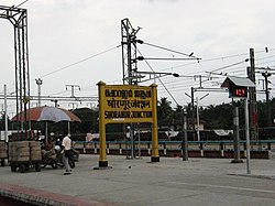
Shoranur
Shoranur | |
|---|---|
Town | |
 Shoranur Junction railway station, the largest railway station in the state in terms of area. | |
| Coordinates: 10°46′N 76°17′E / 10.77°N 76.28°E | |
| Country | India |
| State | Kerala |
| District | Palakkad |
| Government | |
| • Body | Municipality |
| • Chairperson | M. K. Jayaprakash |
| Area | |
| • Total | 32.28 km2 (12.46 sq mi) |
| Elevation | 49 m (161 ft) |
| Population (2011) | |
| • Total | 43,533 |
| • Density | 1,300/km2 (3,500/sq mi) |
| Languages | |
| • Official | Malayalam, English |
| Time zone | UTC+5:30 (IST) |
| PIN | 679121 |
| Telephone code | 0466 |
| Sex ratio | 1000:1096 ♂/♀ |
| Website | www |
Shoranur is a town and a municipality located in the Palakkad district, in the Indian state of Kerala, located on the banks of the Bharathapuzha River. The town covers an area of 32.28 km2.
Geography
[edit]Shoranur is located at 10°46′N 76°17′E / 10.77°N 76.28°E.[1] It has an average elevation of 49 metres (160 feet).
History
[edit]This place was originally a part of the Nedunganad Swaroopam dynasty, which ruled over the present-day Pattambi and Ottapalam Taluks.[2] By the end of the 15th century CE, Nedunganad came under the Zamorin of Calicut.[2] The Chieftains of Shoranur known as the Kavalappara Moopil Nair maintained his territory as a buffer zone between the Zamorin and the Rajas of kochi often taking sides keeping in mind his personal interests of the time .[2] With the annexation of Malabar by the British Kavalappara became part of Walluvanad Taluk of Malabar District, with the Taluk headquarters at Perinthalmanna.[2]
Politics
[edit]Shoranur became a municipality in 1978 and is divided into 33 electoral wards. It is a part of Shoranur Legislative Assembly Constituency and Palakkad Parliamentary Constituency.[3] Shoranur assembly constituency was formed in 2011. Before that Shoranur municipality was under Pattambi assembly constituency.
Transport
[edit]Shoranur well connected by road to the nearest cities of Thrissur and Palakkad . SH 22 which is also called the Shoranur - Kodungallur road passes through Thrissur, while the Ponnani - Palakkad road passes through Kulappully.
There are regular bus services to Ottapalam, Thrissur, Chelakkara, Pattambi and Cherpulassery from shoranur. Kulappully serves buses from Palakkad and Guruvayur.
Shoranur Junction is the largest railway station in Kerala and it handle trains to almost all parts of the country. The most popular daily express in Kerala the Venad Express runs between Shoranur and Trivandrum.
Educational institutions
[edit]- Institute Of Printing Technology & Government Polytechnic College, Shoranur
- Institute for Communicative and Cognitive Neurosciences, Kavalapara, Shoranur
- Vishnu Ayurveda College, Kulapully, Shoranur
- MPMMSN Trust College, Shoranur
- Carmel CMI School, Shoranur
- Al Ameen Engineering College
- Jyoti engineering college, Cheruthuruthy
- National Research Institute for Panchakarma, Cheruthuruthy
Notable people
[edit]- Balan K. Nair, actor
- Meghanathan, actor
- A. K. Lohithadas, film director
Villages
[edit]See also
[edit]References
[edit]- ^ Falling Rain Genomics, Inc - Shoranur
- ^ a b c d Logan, William (2010). Malabar Manual (Volume-I). New Delhi: Asian Educational Services. pp. 631–666. ISBN 9788120604476.
- ^ maps of india - shornur assembly constituency
- ^ "Polling Booth in Shornur Assembly Constituency". elections.in. Retrieved 27 June 2023.


