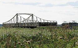
Somerleyton Swing Bridge
Appearance
Somerleyton Swing Bridge | |
|---|---|
 | |
| Coordinates | 52°30′44.50″N 1°38′48.75″E / 52.5123611°N 1.6468750°E |
| Carries | Wherry railway line |
| Crosses | River Waveney |
| Locale | Somerleyton, Suffolk, England |
| Maintained by | Network Rail[1][2] |
| Characteristics | |
| Design | Swing bridge |
| Width | 54 feet (16.5 m)[2] |
| Clearance below | 8.5 feet (2.59 m)[2] |
| Rail characteristics | |
| No. of tracks | 2 |
| Track gauge | 1,435 mm (56.5 in) |
| History | |
| Inaugurated | 1905 |
| Replaces | Previous single-track bridge |
| Location | |
 | |
Somerleyton Swing Bridge is a railway swing bridge over the River Waveney on the Norfolk-Suffolk border.
It was built in 1905 to carry the double tracked Norwich to Lowestoft Line over the river, replacing a previous single tracked bridge.[3] It is 400 metres (1,300 ft) west of Somerleyton railway station and near the Suffolk village of Somerleyton. It is one of only four remaining railway swing bridges crossing rivers in The Broads.[citation needed]
References
[edit]- ^ "Swing bridge renewals". www.networkrail.co.uk. Retrieved 26 March 2023.
- ^ a b c "Bridge heights and openings". www.broads-authority.gov.uk. Retrieved 26 March 2023.
- ^ "Somerleyton Swing Bridge". Engineering Timelines. Retrieved 15 June 2015.
External links
[edit]Wikimedia Commons has media related to Somerleyton Swing Bridge.
