Srem District
Srem District Sremski okrug Сремски округ | |
|---|---|
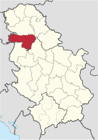
 Location of the Srem District within Serbia | |
| Coordinates: 44°59′N 19°37′E / 44.983°N 19.617°E | |
| Country | |
| Province | |
| Administrative center | Sremska Mitrovica |
| Government | |
| • Commissioner | Dušanka Nuleši (acting) |
| Area | |
| • Total | 3,486 km2 (1,346 sq mi) |
| Population (2022 census) | |
| • Total | 282,547 |
| • Density | 81/km2 (210/sq mi) |
| ISO 3166 code | RS-07 |
| Municipalities | 6 and 1 city |
| Settlements | 109 |
| - Cities and towns | 7 |
| - Villages | 102 |
| Website | www |


The Srem District (Serbian: Сремски округ / Sremski okrug, pronounced [srɛ̂ːmskiː ôkruːɡ]) is one of seven administrative districts of the autonomous province of Vojvodina, Serbia. It lies in the geographical regions of Srem and Mačva. According to the 2022 census results, it has a population of 282,547 inhabitants. The administrative center is the city of Sremska Mitrovica.
Name
[edit]In Serbian, the district is known as Sremski okrug (Сремски округ), in Croatian as Srijemski okrug, in Hungarian as Szerémségi Körzet, in Slovak as Sriemskí okres, in Rusyn as Srimski okruh (Сримски окрух), and in Romanian as Districtul Srem.
Administration
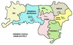
[edit]The Srem District is one of seven districts (first-level administrative divisions) of Vojvodina (and 29 of Serbia). Districts are regional centers and do not have any form of self-government. The District includes the municipalities of:
History
[edit]In Late antiquity, between the 3rd and 5th centuries, the city of Sirmium (present-day Sremska Mitrovica) was a capital of the Roman province of Pannonia Secunda. In the 6th century Sirmium was the capital of Byzantine Pannonia. In the 7th century, during Avar administration, the area was ruled by Bulgar local ruler Kuber, while in the 11th century, it was ruled by independent Bulgarian-Slavic duke Sermon. In the 11th century, it was part of the Byzantine Theme of Sirmium.
During the administration of the medieval Kingdom of Hungary (12th–16th century), the area was divided between Sirmiensis and Valkoensis counties. During Ottoman administration (16th–18th century), the area was initially a part of the vassal Ottoman duchy of Syrmia ruled by Serb duke Radoslav Čelnik and was subsequently included into the Sanjak of Syrmia.
At the end of the Austro-Russian-Turkish War of 1735-1739, there was a migration of Albanians from the Kelmendi tribe to Srem, who were recorded as speaking Albanian as late as 1921.[1]
During Habsburg administration (18th-19th century), the area was divided between the Syrmia County and the Military Frontier. In the 1850s, northern parts of the area were part of the Novi Sad District, but were again included into Syrmia County after 1860. Since the abolishment of the Military Frontier in 1882, Syrmian parts of the Frontier were also included into Syrmia County.
During the royal Serb-Croat-Slovene (Yugoslav) administration (1918–1941), the area was part of the Syrmia County (1918–1922) and Syrmia Oblast (1922–1929). From 1929 to 1931, the area was divided between Danube Banovina in the north-east and Drina Banovina in the south-west, while from 1931 to 1939 the area was part of the Danube Banovina. From 1939 to 1941, north-western parts of the area were part of the Banovina of Croatia.
During the German-Croatian Axis occupation (1941–1944), the area was included into the Grand County of Vuka. Since 1944, the area was part of autonomous Yugoslav Vojvodina (which was part of new socialist Yugoslav Serbia since 1945). The present-day districts of Serbia (including Syrmia District) were defined by the Government of Serbia's Enactment of 29 January 1992.
Demographics
[edit]| Year | Pop. | ±% |
|---|---|---|
| 1948 | 209,943 | — |
| 1953 | 223,642 | +6.5% |
| 1961 | 260,226 | +16.4% |
| 1971 | 287,474 | +10.5% |
| 1981 | 306,085 | +6.5% |
| 1991 | 309,981 | +1.3% |
| 2002 | 335,901 | +8.4% |
| 2011 | 312,278 | −7.0% |
| 2022 | 282,547 | −9.5% |
| Source: [2] | ||
According to the last official census done in 2011, the Srem District has 312,278 inhabitants.
Ethnic groups
[edit]Ethnic composition of the Srem district:[3]
| Ethnic group | Population | % |
|---|---|---|
| Serbs | 265,272 | 84.95% |
| Croats | 8,758 | 2.80% |
| Slovaks | 8,154 | 2.61% |
| Romani | 5,488 | 1.76% |
| Hungarians | 3,789 | 1.21% |
| Rusyns | 1,689 | 0.54% |
| Yugoslavs | 1,122 | 0.36% |
| Ukrainians | 1,055 | 0.34% |
| Macedonians | 606 | 0.19% |
| Montenegrins | 493 | 0.16% |
| Germans | 249 | 0.08% |
| Muslims | 246 | 0.08% |
| Slovenes | 244 | 0.08% |
| Russians | 183 | 0.06% |
| Albanians | 173 | 0.06% |
| Others | 14,757 | 4.73% |
| Total | 312,278 |
Culture
[edit]The monasteries on the Fruška Gora mountain are the greatest cultural treasures of this region. There are 16 active monasteries, mostly dating back from the late middle ages, including Grgeteg Monastery, Jazak Monastery and Velika Remeta.[4] The Krušedol Monastery is a true treasury of the Vojvodinan painting. It was founded in 1514 as an endowment of Orthodox bishop Maksim Branković and his mother Angelina. In the Novo Hopovo Monastery, the church architecture and fresco paintings are particularly attractive. The exact time of its first construction is unknown, but 1765 is known as the year of its reconstruction.
Archeological Museum Carska Palata (Royal Palace) in Sremska Mitrovica is dedicated to the remains of the Roman town Sirmium, dating back to 1st century BC.[5]
A museum dedicated to the prominent Serbian artist Sava Šumanović is located in his hometown of Šid. It consists of the Gallery with 417 works of art, donated by Sava's mother Persida Šumanovic, and the Memorial House, where the painter used to live with his family.[6]
See also
[edit]References
[edit]- ^ "Karl Gottlieb von Windisch: On the Kelmendi in Syrmia".
- ^ "2011 Census of Population, Households and Dwellings in the Republic of Serbia" (PDF). stat.gov.rs. Statistical Office of the Republic of Serbia. Retrieved 16 January 2017.
- ^ "Попис становништва, домаћинстава и станова 2011. у Републици Србији" (PDF). stat.gov.rs. Republički zavod za statistiku. Retrieved 16 January 2017.
- ^ "Sremska Mitrovica". www.sremskamitrovica.rs. Retrieved 2024-07-02.
- ^ "Sirmium | WordPress Website" (in Serbian). Retrieved 2024-07-08.
- ^ "Галерија слика "Сава Шумановић"". www.savasumanovic.rs. Retrieved 2024-07-09.
Note: All official material made by Government of Serbia is public by law. Information was taken from official website.


