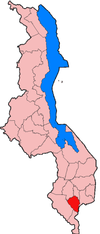
Thyolo District
This article needs additional citations for verification. (December 2009) |

The Thyolo district of Malawi is one of the districts in Malawi. The capital is Thyolo. The district covers an area of 1,715 km.²1. and has a population of 458,976.[1] It is also has crossroads leading to Makwasa, Molere, Konzalendo, Thekerani into Muona and eventually Nsanje leading to another border with Mozambique. Sources 1. Malawi Government, Thyolo District Council, Socio-economic Profile,2017-2022
Demographics
[edit]At the time of the 2018 Census of Malawi, the distribution of the population of Thyolo District by ethnic group was as follows:[2]
- 77.2% Lomwe
- 12.3% Mang'anja
- 3.3% Ngoni
- 2.1% Yao
- 1.2% Sena
- 1.1% Chewa
- 0.3% Tumbuka
- 0.2% Nyanja
- 0.1% Tonga
- 0.1% Nkhonde
- 0.0% Lambya
- 0.0% Sukwa
- 2.1% Others
Government and administrative divisions
[edit]There are seven National Assembly constituencies in Thyolo:
- Thyolo - Central
- Thyolo - East
- Thyolo - North
B.
- Thyolo - South
- Thyolo - South West
- Thyolo - Thava
- Thyolo - West
Since the 2009 election all of these constituencies have been held by members of the Democratic Progressive Party.[3]
Thyolo is one of the southernmost districts of Malawi, and is bordered by 5 others as well as Mozambique.
References
[edit]- ^ "Thyolo, Thyolo District, Southern Region, Malawi". www.mindat.org. Retrieved 2020-05-27.
- ^ 2018 Malawi Population and Housing Census Main Report
- ^ Parliament of Malawi - Members of Parliament - Thyolo District
