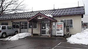
Wakinoda Station
Wakinoda Station | |
|---|---|
 The station building in March 2013 | |
| General information | |
| Location | 2 Yamato, Jōetsu, Niigata ( Japan |
| Operated by | JR East |
| Line(s) | Shinetsu Main Line |
| History | |
| Opened | 1921 |
| Closed | 2014 |
| Passengers | |
| FY2013 | 139 daily |
Wakinoda Station (
Lines
[edit]Wakinoda Station was served by the Shinetsu Main Line. A new interchange station called Jōetsumyōkō Station was built close by, and this replaced Wakinoda Station when the Hokuriku Shinkansen opened in March 2015.[1]
Station layout
[edit]The station had a single ground-level island platform serving two tracks.
Platforms
[edit]| 1 | ■ Shinetsu Main Line | for Arai and Nagano |
| 2 | ■ Shinetsu Main Line | for Naoetsu, Nagaoka, and Niigata |
Adjacent stations
[edit]| « | Service | » | ||
|---|---|---|---|---|
| Shinetsu Main Line | ||||
| Rapid Myōkō: Does not stop at this station | ||||
| Minami-Takada | Rapid Kubikino | Kita-Arai | ||
| Minami-Takada | Local | Kita-Arai | ||
History
[edit]
Wakinoda Station opened on 15 August 1921.[2] With the privatization of JNR on 1 April 1987, the station came under the control of JR East.[2]
From 19 October 2014, the station building and platforms were closed, and the station functions moved to the nearby structure, and became Jōetsumyōkō Station from 14 March 2015 when the Hokuriku Shinkansen opened for service.[3] Today, nothing remains of the former railway station - the station platforms and buildings were demolished for redevelopment, whilst the railway line was re-routed to stop at the new station. A portion of the old alignment of the line now has a road built along the former alignment.
Passenger statistics
[edit]In fiscal 2013, the station was used by an average of 139 passengers daily (boarding passengers only).[4] The passenger figures for previous years are as shown below.
| Fiscal year | Daily average |
|---|---|
| 2000 | 145[5] |
| 2005 | 135[6] |
| 2010 | 119[7] |
| 2011 | 122[8] |
| 2012 | 121[9] |
| 2013 | 139[4] |
References
[edit]- ^ Tokunaga, Yasushi (December 2013).
上越 妙高 駅 に生 まれ変 わる脇野田 駅 [Wakinoda Station to be reborn as Joetsu-Myoko Station]. Japan Railfan Magazine (in Japanese). 53 (632). Japan: Koyusha Co., Ltd.: 26–27. - ^ a b Ishino, Tetsu, ed. (1998).
停車場 変遷 大 辞典 国鉄 ・JR編 [Station Transition Directory - JNR/JR]. Vol. II. Japan: JTB. p. 581. ISBN 4-533-02980-9. - ^ a b
各駅 の乗車 人員 (2013年度 ) [Station passenger figures (Fiscal 2013)] (in Japanese). Japan: East Japan Railway Company. 2014. Retrieved 22 November 2014. - ^
各駅 の乗車 人員 (2000年度 ) [Station passenger figures (Fiscal 2000)] (in Japanese). Japan: East Japan Railway Company. 2001. Retrieved 25 October 2013. - ^
各駅 の乗車 人員 (2005年度 ) [Station passenger figures (Fiscal 2005)] (in Japanese). Japan: East Japan Railway Company. 2006. Retrieved 25 October 2013. - ^
各駅 の乗車 人員 (2010年度 ) [Station passenger figures (Fiscal 2010)] (in Japanese). Japan: East Japan Railway Company. 2011. Retrieved 25 October 2013. - ^
各駅 の乗車 人員 (2011年度 ) [Station passenger figures (Fiscal 2011)] (in Japanese). Japan: East Japan Railway Company. 2012. Retrieved 25 October 2013. - ^
各駅 の乗車 人員 (2012年度 ) [Station passenger figures (Fiscal 2012)] (in Japanese). Japan: East Japan Railway Company. 2013. Retrieved 22 November 2014.
External links
[edit]- JR East Wakinoda Station (in Japanese)
