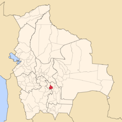
Yamparáez Province
Appearance
Yamparáez Province | |
|---|---|
Province | |
 Market in Tarabuco | |
 Location of Oropeza Province within Bolivia | |
| Coordinates: 19°10′S 64°58′W / 19.167°S 64.967°W | |
| Country | |
| Department | Chuquisaca Department |
| Capital | Tarabuco |
| Area | |
| • Total | 627 sq mi (1,625 km2) |
| Population (2024 census) | |
| • Total | 21,788 |
| • Density | 35/sq mi (13/km2) |
| • Ethnicities | Quechuas |
| Time zone | UTC-4 (BOT) |
Yamparáez is a province in the Bolivian department of Chuquisaca. It is divided in two sections: first section with head in the town of Tarabuco, and the second section with its head in Yamparáez.
Subdivision
[edit]The province is divided into two municipalities which are further subdivided into cantons.
| Section | Municipality | Seat |
|---|---|---|
| 1st | Tarabuco Municipality | Tarabuco |
| 2nd | Yamparáez Municipality | Yamparáez |
The people
[edit]The people are predominantly indigenous citizens of Quechuan descent.
| Ethnic group | Tarabuco Municipality (%) | Yamparáez Municipality (%) |
|---|---|---|
| Quechua | 92.9 | 96.5 |
| Aymara | 0.3 | 0.3 |
| Guaraní, Chiquitos, Moxos | 0.1 | 0.1 |
| Not indigenous | 6.6 | 3.0 |
| Other indigenous groups | 0.1 | 0.1 |
Ref.: obd.descentralizacion.gov.bo
Languages
[edit]The languages spoken in the province are mainly Quechua and Spanish.
| Language | Tarabuco Municipality | Yamparáez Municipality |
|---|---|---|
| Quechua | 17,850 | 9,222 |
| Aymara | 52 | 21 |
| Guaraní | 1 | 0 |
| Another native | 2 | 4 |
| Spanish | 5,605 | 4,138 |
| Foreign | 17 | 6 |
| Only native | 12,592 | 5,287 |
| Native and Spanish | 5,271 | 3,938 |
| Only Spanish | 334 | 200 |
Ref.: obd.descentralizacion.gov.bo
19°10′01″S 64°58′01″W / 19.167°S 64.967°W

