Delta Mekong
Delta Mekong
ديلتا ميکوڠ Đồng bằng Sông Cửu Long Đồng Bằng Sông Mê Kông | |
|---|---|
 Sawah padi di Delta Mekong. | |
| Nama panggilan: "Delta sungai Sembilan Naga", "Barat" | |
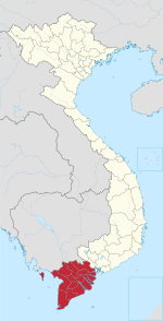
 Peta wilayah | |
| Koordinat: 10°02′N 105°47′E / 10.033°N 105.783°E | |
| Negara | Vietnam |
| Keluasan | |
| • Jumlah | 40,576.6 km2 (15,666.7 batu persegi) |
| Aras | 0 m (0 ft) |
| Penduduk (2019) | |
| • Jumlah | 21,492,987 |
| • Kepadatan | 530/km2 (1,400/batu persegi) |
| Zon waktu | UTC+07:00 (ICT) |
Delta Mekong (Vietnam: Đồng bằng Sông Cửu Long, "delta sungai Sembilan Naga" atau Vietnam: Đồng Bằng Sông Mê Kông, "Delta Sungai Mekong"), juga dikenali sebagai Kawasan Barat (Vietnam: Miền Tây) atau Kawasan barat daya (Vietnam: Tây Nam Bộ) ialah kawasan di barat daya Vietnam di mana Sungai Mekong menghampiri dan mengosongkan ke dalam laut melalui rangkaian alur delta. Kawasan delta Mekong mengelilingi sebahagian besar barat daya Vietnam melebihi 40,500 kilometer persegi (15,600 bt2).[2] Saiz kawasan diliputi air bergantung pada musimnya. Sebelum tahun 1975, Delta Mekong sebahagian Republik Vietnam. Delta Mekong ialah tempat bagi kawasan IV Corps semasa Perang Vietnam. IV Corps satu-satunya kor di Vietnam Selatan yang VC tidak serang nyata sekali sehingga Presiden terakhir Duong Van Minh mengaku kalah kepada Vietnam Utara.
Lihat juga
[sunting | sunting sumber]- Rangkaian Akademik dan Penyelidikan Subkawasan Mekong
- Pusaat Pengendalian Persekitaran GMS
- Pengawasan Penyakit Lembangan Mekong
Nota
[sunting | sunting sumber]Rujukan
[sunting | sunting sumber]- ^ Statistical Handbook of Vietnam 2014 Diarkibkan Julai 6, 2015, di Wayback Machine, General Statistics Office of Vietnam
- ^ Mekong Delta Diarkibkan September 21, 2012, di Wayback Machine on ARCBC (ASEAN Regional Centre for Biodiversity Conservation) site
Bacaan lanjut
[sunting | sunting sumber]- Renaud, F. G. and C. Kuenzer (2012): The Mekong Delta System. Interdisciplinary Analyses of a River Delta (= Springer Environmental Science and Engineering). Dordrecht: Springer. ISBN 978-94-007-3961-1.
- Kuenzer, C. and F. G. Renaud (2012): Climate Change and Environmental Change in River Deltas Globally. In: Renaud, F. G. and C. Kuenzer (eds.): The Mekong Delta System. Interdisciplinary Analyses of a River Delta (= Springer Environmental Science and Engineering). Dordrecht: Springer, pp. 7–48.
- Renaud F. G. and C. Kuenzer (2012): Introduction. In: Renaud, F. G. and C. Kuenzer (eds.): The Mekong Delta System. Interdisciplinary Analyses of a River Delta (= Springer Environmental Science and Engineering). Dordrecht: Springer, pp. 3–6.
- Moder, F., C. Kuenzer, Z. Xu, P. Leinenkugel and Q. Bui Van (2012): IWRM for the Mekong Basin. In: Renaud, F. G. and C. Kuenzer (eds.): The Mekong Delta System. Interdisciplinary Analyses of a River Delta (= Springer Environmental Science and Engineering). Dordrecht: Springer, pp. 133–166.
- Klinger, V., G. Wehrmann, G. Gebhardt and C. Kuenzer (2012): A Water related Web-based Information System for the Sustainable Development of the Mekong Delta. In: Renaud, F. G. and C. Kuenzer (eds.): The Mekong Delta System. Interdisciplinary Analyses of a River Delta (= Springer Environmental Science and Engineering). Dordrecht: Springer, pp. 423–444.
- Gebhardt, S., L. D. Nguyen and C. Kuenzer (2012): Mangrove Ecosystems in the Mekong Delta. Overcoming Uncertainties in Inventory Mapping Using Satellite Remote Sensing Data. In: Renaud, F. G. and C. Kuenzer (eds.): The Mekong Delta System. Interdisciplinary Analyses of a River Delta (= Springer Environmental Science and Engineering). Dordrecht: Springer, pp. 315–330.
- Kuenzer, C., H. Guo, J. Huth, P. Leinenkugel, X. Li and S. Dech (2013): Flood Mapping and Flood Dynamics of the Mekong Delta. ENVISAT-ASAR-WSM Based Time-Series Analyses. In: Remote Sensing 5, pp. 687–715. DOI: 10.3390/rs5020687.
- Gebhardt, S., J. Huth, N. Lam Dao, A. Roth and C. Kuenzer (2012): A comparison of TerraSAR-X Quadpol backscattering with RapidEye multispectral vegetation indices over rice fields in the Mekong Delta, Vietnam. In: International Journal of Remote Sensing 33 (24), pp. 7644–7661.
- Leinenkugel, P., T. Esch and C. Kuenzer (2011): Settlement detection and impervious surface estimation in the Mekong Delta using optical and SAR remote sensing data. In: Remote Sensing of Environment 115 (12), pp. 3007–3019.
- Kuenzer, C., I. Klein, T. Ullmann, E. Foufoula-Georgiou, R. Baumhauer and S. Dech (2015): Remote Sensing of River Delta Inundation: Exploiting the Potential of Coarse Spatial Resolution, Temporally-Dense MODIS Time Series. In: Remote Sensing 7, pp. 8516-8542. DOI: 10.3390/rs70708516.
- Kuenzer, C., H. Guo, I. Schlegel, V. Tuan, X. Li and S. Dech (2013): Varying scale and capability of envisat ASAR-WSM, TerraSAR-X scansar and TerraSAR-X Stripmap data to assess urban flood situations: A case study of the mekong delta in Can Tho province. In: Remote Sensing 5 (10), pp. 5122-5142. DOI: 10.3390/rs5105122.
Pautan luar
[sunting | sunting sumber]- The WISDOM Project, a Water related Information System for the Mekong Delta
- Image Google map of the Mekong Delta.
- Fruits found at Mekong Delta
- Climate change
- Mekong Delta Climate Change Forum 2009 Documents Diarkibkan 2016-03-04 di Wayback Machine. International Centre for Environmental Management.
- Release of arsenic to deep groundwater in the Mekong Delta, Vietnam, linked to pumping-induced land subsidence.
Templat:Subdivisions of Vietnam Templat:Districts of Mekong Delta
- Delta Mekong
- Sungai Mekong
- Sungai Saigon
- Delta sungai di Asia
- Bentuk bumi Vietnam
- Kawasan di Vietnam
- Simpanan biosfera Vietnam
- Bentuk bumi Laut China Selatan
- Bentuk bumi Wilayah An Giang
- Bentuk bumi Wilayah Bac Lieu
- Bentuk bumi Wilayah Ben Tre
- Bentuk bumi Wilayah Ca Mau
- Bentuk bumi Wilayah Dong Thap
- Bentuk bumi Wilayah Hau Giang
- Bentuk bumi Wilayah Kien Giang
- Bentuk bumi Wilayah Long An
- Bentuk bumi Wilayah Soc Trang
- Bentuk bumi Wilayah Tiền Giang
- Bentuk bumi Wilayah Tra Vinh
- Bentuk bumi Wilayah Vinh Long
- Bentuk bumi Cần Thơ
- Pertikaian wilayah Vietnam
- Pertikaian wilayah Cambodia
