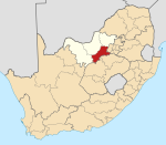
Vaal Reefs
Appearance
| Vaal Reefs Coordinates: 26°55′44″S 26°44′10″E / 26.929°S 26.736°E{{#coordinates:}}: cannot have more than one primary tag per page | |
|---|---|
| Coordinates: 26°55′44″S 26°44′10″E / 26.929°S 26.736°E | |
| Naga | Afrika Borwa |
| Porofense | Leboa Bodikela |
| Mmasepala wa Selete | Dr Kenneth Kaunda |
| Mmušôselegae | City of Matlosana |
| Sekgôba[1] | |
| • Total | 6.15 km2 (2.37 sq mi) |
| Setšhaba (2001)[1] | |
| • Total | 11,345 |
| • Phitlaganyo | 1,800/km2 (4,800/sq mi) |
| Dipersente tša merafe (2001)[1] | |
| • Bathobaso | 94.8% |
| • Bammala | 0.2% |
| • Makgowa | 5.0% |
| Dipolelo tša ntlha (2001)[1] | |
| • Sethosa | 34.7% |
| • Sesotho | 26.1% |
| • Setswana | 14.3% |
| • Setsonga | 6.0% |
| • Šele | 18.9% |
| Nomoro ya poso (Setarata) | Molaô la pôsô |
| Nomoro ya poso (Lepokisi) | Molaô la pôsô |
Vaal Reefs ke mining toropo go feta profense Leboa Bodikela ka moka Afrika Borwa.
Ditšhupetšo
- ↑ 1.0 1.1 1.2 1.3 "Main Place Vaal Reefs". Census 2001.
Bomasepala ba le metseng ea Mmasepala Setereke tša Dr Kenneth Kaunda, Leboa Bodikela | ||
|---|---|---|
| District seat: Klerksdorp | ||
| JB Marks | Appeldraai • Boskop • Bruidegomskraal • Doornkop • Frederikstad • GaMogopa • Goedgevonden A • Ikageng • Lindequesdrif • Makokskraal • Matlwang • Mohadin • Mooivalleipark • Potchefstroom • Promosa • Tshing • Ventersdorp • Venterskroon • Vlieger • Welgevonden |  |
| City of Matlosana | Dominionville • Doringkruin • Hartbeesfontein • Kanana • Klerksdorp • Orkney • Tigane • Umzimhle • Stilfontein • Vaal Reefs | |
| Maquassi Hills | Boskuil • Kgakala • Leeudoringstad • Maquassi/Makwassie • Rulaganyang • Trotsville • Tswelelang • Witpoort • Wolmaransstad | |

