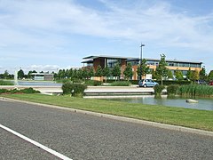
South Cambridgeshire
| dystrykt niemetropolitalny | |
 Cambourne | |
| Państwo | |
|---|---|
| Kraj | |
| Region | |
| Hrabstwo | |
| Siedziba | |
| Powierzchnia |
901,63 km² |
| Populacja (2011) • liczba ludności |
|
| • gęstość |
170 os./km² |
Położenie na mapie Cambridgeshire
| |
| Strona internetowa | |
South Cambridgeshire – dystrykt w hrabstwie Cambridgeshire w Anglii. W 2011 roku dystrykt liczył 148 755 mieszkańców[1].
Miasta
[edytuj | edytuj kod]Inne miejscowości
[edytuj | edytuj kod]Abington Pigotts, Abington, Arrington, Babraham, Balsham, Bar Hill, Barrington, Bartlow, Barton, Bassingbourn cum Kneesworth, Bourn, Caldecote, Cambourne, Carlton, Castle Camps, Caxton, Chittering, Comberton, Conington, Coton, Cottenham, Croxton, Croydon, Dry Drayton, Duxford, Elsworth, Eltisley, Fen Ditton, Fen Drayton, Flint Cross, Foxton, Gamlingay, Graveley, Great Shelford, Great Wilbraham, Hardwick, Harlton, Harston, Haslingfield, Hatley, Hildersham, Hinxton, Histon, Horningsea, Horseheath, Ickleton, Impington, Knapwell, Landbeach, Linton, Litlington, Little Chishill, Little Gransden, Little Shelford, Little Wilbraham, Lolworth, Longstanton, Longstowe, Madingley, Melbourn, Meldreth, Milton, Newton, Oakington, Orwell, Papworth Everard, Papworth St Agnes, Sawston, Shepreth, Shingay, Six Mile Bottom, Steeple Morden, Stow cum Quy, Tadlow, Thriplow, Waterbeach, West Wickham, Weston Colville, Whaddon, Whittlesford, Wimpole.
Przypisy
[edytuj | edytuj kod]- ↑ Area: South Cambridgeshire (Local Authority). Neighbourhood Statistics (ONS). [dostęp 2016-05-06]. [zarchiwizowane z tego adresu (2016-10-10)]. (ang.).
