Province of Valladolid
Appearance
Valladolid | |
|---|---|
       From top to bottom and from left to right: The Castle of Peñafiel, Canal of Castile, typical landscape of the province, a pine forest, center of a Castilian town, Castle of La Mota and a wine cellar. | |
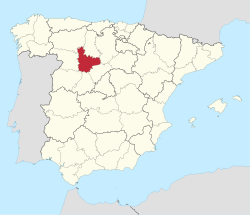
 Map of Spain with Valladolid highlighted | |
| Coordinates: 41°35′N 4°40′W / 41.583°N 4.667°W | |
| Country | Spain |
| Autonomous community | Castile and León |
| Capital | Valladolid |
| Area | |
| • Total | 8,110 km2 (3,130 sq mi) |
| • Rank | Ranked 28th |
| 1.61% of Spain | |
| Population (2015) | |
| • Total | 526,223 |
| • Rank | Ranked 29th |
| • Density | 65/km2 (170/sq mi) |
| 1.14% of Spain | |
| Demonym | Spanish: Vallisoletano/a |
| Official language(s) | Spanish |
| Parliament | Cortes Generales |
| Website | diputaciondevalladolid.es |
Valladolid (Spanish: [baʎaðoˈlið] (![]() listen)) is a province of northwest Spain, in the central part of the autonomous community of Castile and León. It has a population of 526,223 people in a total of 225 cities.
listen)) is a province of northwest Spain, in the central part of the autonomous community of Castile and León. It has a population of 526,223 people in a total of 225 cities.
The capital is the city of Valladolid. It is bordered by the provinces of Zamora, León, Palencia, Burgos, Segovia, Ávila, and Salamanca.
Other websites[change | change source]
- Valladolid Province Tourism Board official Website Archived 2014-12-19 at the Wayback Machine


