Arctic Cordillera
Appearance
| Arctic Cordillera | |
|---|---|
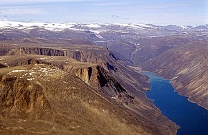
 Baffin Mountains ecoregion of the Arctic Cordillera | |
 | |
| Ecology | |
| Borders | Northern Arctic and Taiga Shield |
| Geography | |
| Area | 242,190 km2 (93,510 sq mi) |
| Country | Canada |
| Provinces | Newfoundland and Labrador, Nunavut and Quebec |
| Coordinates | 81°56′N 74°54′W / 81.93°N 74.90°W |
| Climate type | Polar and Ice cap |
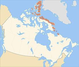
The Arctic Cordillera is a mountain range running along the northeastern coast of North America from Ellesmere Island to the northernmost tip of Labrador. It is the only major mountain range in Canada east of the Rocky Mountains. The range has a surface area of 218,225 km2 (84,257 sq mi). Its highest point is 2,616 metres (8,583 ft) at Barbeau Peak.
Further reading
[change | change source]Wikimedia Commons has media related to Arctic Cordillera.
- Chernoff, M. N., H. R. Hovdebo, and J. Stuart-Smith. Eastern Canadian Cordillera and Arctic Islands An Aerial Reconnaissance. Ottawa: 24th International Geological Congress, 1972.
- Geological Survey of Canada. Cordillera and Pacific Margin Interior Plains and Arctic Canada. Geological Survey of Canada Current Research, 1998-A. 1998.
- Hall, John K. Arctic Ocean Geophysical Studies The Alpha Cordillera and Mendeleyev Ridge. Palisades, N.Y.: Lamont-Doherty Geological Observatory, Columbia University, 1970.
- Walker, Edward R. A Synoptic Climatology for Parts of the Western Cordillera. Montreal: McGill University, 1961.
