Bangka Belitung Islands
Appearance
Bangka Belitung Islands | |
|---|---|
| Motto(s): Serumpun Sebalai (Allied Disgust) | |
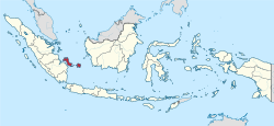
 Location of Bangka Belitung in Indonesia | |
| Coordinates: 2°8′S 106°7′E / 2.133°S 106.117°E | |
| Established | 4 December 2000[1] |
| Capital and largest city | Pangkal Pinang |
| Government | |
| • Body | Bangka Belitung Islands Provincial Government |
| • Governor | Erzaldi Rosman Djohan |
| • Vice Governor | Abdul Fatah |
| Area | |
| • Total | 16,424.14 km2 (6,341.40 sq mi) |
| • Rank | 27th in Indonesia |
| Highest elevation | 669 m (2,195 ft) |
| Population | |
| • Total | 1,430,900 |
| • Rank | 29th in Indonesia |
| • Density | 87/km2 (230/sq mi) |
| Demographics | |
| • Ethnic groups |
|
| • Religion |
|
| • Languages | |
| Time zone | UTC+7 (Indonesia Western Time) |
| HDI | |
| HDI rank | 15th in Indonesia (2014) |
| Website | babelprov |
The Bangka Belitung Islands (Indonesian: Kepulauan Bangka Belitung) is a province of Indonesia. It is made up of two main islands, Bangka and Belitung, and several smaller ones.
Bangka Belitung is bordered by the Bangka Strait to the west, the Natuna Sea to the north, the Java Sea is to the south, and the Karimata Strait to the east.
The province's capital and largest city is Pangkal Pinang. As of the 2015 census, the population of Bangka Belitung was 1,372,813.
References
[change | change source]- ↑ "Undang-Undang Republik Indonesia Nomor 27 Tahun 2000" (PDF). dpr.go.id (in Indonesian). People's Representative Council. Archived from the original (PDF) on 27 March 2015. Retrieved 9 March 2020.
- ↑ "Statistik Indonesia 2018". Badan Pusat Statistik. Retrieved July 23, 2018.
- ↑ Central Bureau of Statistics: Census 2010 Archived 2017-11-20 at the Wayback Machine, retrieved 17 January 2011 (in Indonesian)
- ↑ "Kewarganegaraan, Suku Bangsa, Agama dan Bahasa Sehari-hari Penduduk Indonesia 2010". BPS Indonesia. Retrieved 14 July 2018.
- ↑ "Population by Area and Religion of Bangka Belitung 2010" Retrieved 13 July 2018


