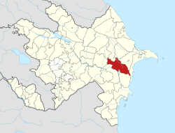
Hajigabul District
Appearance
Hacıqabul Raion | |
|---|---|
 Map of Azerbaijan showing Hajigabul Raion | |
| Coordinates: 40°02′17″N 48°56′13″E / 40.037999°N 48.937038°E | |
| Country | Azerbaijan |
| Capital | Qazıməmməd (Hacıqabul city) |
| Area | |
| • Total | 1,640 km2 (630 sq mi) |
| Population (1999) | |
| • Total | 57,944 |
| Postal code | AZ2400 |
| Telephone code | 0140 |
Hajigabul (Hacıqabul) is a raion of Azerbaijan. There are 31 populated areas. The Pirsaat River and valley is in this raion.

