Larimore, North Dakota
Appearance
Larimore, North Dakota | |
|---|---|
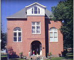
 Larimore Museum | |
 Location of Larimore, North Dakota | |
| Coordinates: 47°54′30″N 97°37′35″W / 47.90833°N 97.62639°W | |
| Country | United States |
| State | North Dakota |
| County | Grand Forks |
| Metro | Greater Grand Forks |
| Founded | 1881 |
| Area | |
| • Total | 0.60 sq mi (1.56 km2) |
| • Land | 0.60 sq mi (1.56 km2) |
| • Water | 0.00 sq mi (0.00 km2) |
| Elevation | 1,132 ft (345 m) |
| Population | |
| • Total | 1,260 |
| • Density | 2,096.51/sq mi (809.01/km2) |
| Time zone | UTC-6 (Central (CST)) |
| • Summer (DST) | UTC-5 (CDT) |
| ZIP code | 58251 |
| Area code | 701 |
| FIPS code | 38-45020 |
| GNIS feature ID | 1036120[2] |
| Highways | ND 18 |
| Website | larimorend.com |
Larimore is a city in Grand Forks County, North Dakota, United States. The population was 1,260 at the 2020 census.[3] Larimore was founded in 1881.
References
[change | change source]- ↑ "ArcGIS REST Services Directory". United States Census Bureau. Retrieved September 20, 2022.
- ↑ 2.0 2.1 U.S. Geological Survey Geographic Names Information System: Larimore, North Dakota
- ↑ 3.0 3.1 "Profile of General Population and Housing Characteristics: 2020 Demographic Profile Data (DP-1): Larimore city, North Dakota". United States Census Bureau. Retrieved February 17, 2024.
