Province of Ancona
Province of Ancona | |
|---|---|
 Piazza del Plebiscito, Ancona | |
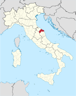 Map with the province of Ancona, in red, in Italy | |
| Coordinates: 43°37′N 13°31′E / 43.617°N 13.517°E | |
| Country | |
| Region | Marche |
| Capital | Ancona |
| Comuni | 47 |
| Government | |
| • President | Liana Serrani[1] |
| Area | |
| • Total | 1,963.22 km2 (758.00 sq mi) |
| Population (1 January 2017)[2] | |
| • Total | 474,124 |
| • Density | 240/km2 (630/sq mi) |
| Time zone | UTC+1 (CET) |
| • Summer (DST) | UTC+2 (CEST) |
| Postal code | 60100 |
| Telephone prefix | 071 |
| Vehicle registration | AN |
| ISTAT | 042 |
| Website | Official website |
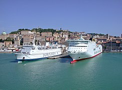
The province of Ancona (Italian: provincia di Ancona) is a province in the Marche region of Central Italy. Its capital is the city of Ancona, and the province borders the Adriatic Sea. The city of Ancona is also the capital of Marche.
Geography
[change | change source]
Ancona has an area of 1,963.22 km2 (758 sq mi).[1] The province is bordered to the northeast and east by the Adriatic Sea, to the northwest by the province of Pesaro and Urbino, to the west with Umbria (province of Perugia) and to the south with the province of Macerata.
The main rivers in the province, from north to south, areː
The highest point in the province is Serra Santa-Cima Nord,(43°14′42″N 12°49′34″E / 43.24500°N 12.82611°E) in the Apennines; it is 1,421 m (4,662 ft) high.[3]
Population
[change | change source]There are 474,124 persons living in the province (1 January 2017),[2] for a population density of 241.5 inhabitants/km².
Evolution of the population

Municipalities
[change | change source]There are 47 municipalities (or comuni) in the province; they are:
- Agugliano
- Ancona
- Arcevia
- Barbara
- Belvedere Ostrense
- Camerano
- Camerata Picena
- Castelbellino
- Castelfidardo
- Castelleone di Suasa
- Castelplanio
- Cerreto d'Esi
- Chiaravalle
- Corinaldo
- Cupramontana
- Fabriano
- Falconara Marittima
- Filottrano
- Genga
- Jesi
- Loreto
- Maiolati Spontini
- Mergo
- Monsano
- Monte Roberto
- Monte San Vito
- Montecarotto
- Montemarciano
- Morro d'Alba
- Numana
- Offagna
- Osimo
- Ostra
- Ostra Vetere
- Poggio San Marcello
- Polverigi
- Rosora
- San Marcello
- San Paolo di Jesi
- Santa Maria Nuova
- Sassoferrato
- Senigallia
- Serra de' Conti
- Serra San Quirico
- Sirolo
- Staffolo
- Trecastelli
The largest comune is Fabriano, with 272.08 km2 (105 sq mi) and the smallest is Concamarise, with 6.05 km2 (2 sq mi). Only two comuni have less than 1,000 inhabitants (2017)ː San Paolo di Jesi with 912 inhabitants, and Poggio San Marcello with 685 inhabitants.
Main comuni
[change | change source]The following table shows the 10 comuni with more inhabitants with their population,[2] and their area and altitude.[4]
| No. | Comune | Population (2017) |
Area (km²) |
Density | Altitude (m) |
|---|---|---|---|---|---|
| 1 | Ancona | 100,696 | 124.84 | 806.6 | 16 |
| 2 | Senigallia | 44,706 | 117.77 | 379.6 | 5 |
| 3 | Jesi | 40,318 | 108.90 | 370.2 | 97 |
| 4 | Osimo | 34,918 | 106.74 | 327.1 | 265 |
| 5 | Fabriano | 31,212 | 272.08 | 114.7 | 325 |
| 6 | Falconara Marittima | 26,331 | 25.82 | 1,019.8 | 5 |
| 7 | Castelfidardo | 18,679 | 33.39 | 559.4 | 199 |
| 8 | Chiaravalle | 14,800 | 17.60 | 840.9 | 22 |
| 9 | Loreto | 12,810 | 17.90 | 715.6 | 127 |
| 10 | Montemarciano | 9,930 | 22.31 | 445.1 | 92 |
Gallery
[change | change source]-
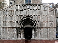
Santa Maria della Piazza, Ancona.
Related pages
[change | change source]References
[change | change source]- ↑ 1.0 1.1 1.2 "Provincia di Ancona" (in Italian). Tuttitalia.it. Retrieved 14 June 2016.
- ↑ 2.0 2.1 2.2 "Statistiche demografiche ISTAT" (in Italian). Demo.istat.it. Archived from the original on 3 January 2018. Retrieved 1 November 2017.
- ↑ "Serra Santa-Cima Nord, Italy". Peakbagger.com. Retrieved 27 June 2017.
- ↑ "Comuni in provincia di Ancona per popolazione" (in Italian). Tuttitalia.it. Retrieved 1 November 2017.
Other websites
[change | change source]- Province of Ancona official website (in Italian)

