Votorantim
Utseende
| Votorantim | |||
| Kommun | |||
|
|||
| Land | |||
|---|---|---|---|
| Delstat | São Paulo | ||
| Koordinater | 23°32′49″S 47°26′16″V / 23.54694°S 47.43778°V | ||
| Area | |||
| - kommun | 184,1 km²[1] | ||
| Folkmängd | |||
| - centralort | 104 659 (1 augusti 2010)[1] | ||
| - kommun | 116 706 (1 juli 2014)[1] | ||
| Befolkningstäthet | |||
| - kommun | 634 invånare/km² | ||
| Geonames | 6322655 | ||
|
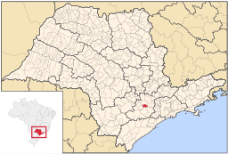
Kommunens läge i delstaten.
| |||
| Webbplats: http://www.votorantim.sp.gov.br/ | |||
Votorantim är en stad och kommun i Brasilien och ligger i delstaten São Paulo. Folkmängden uppgick år 204 till cirka 117 000 invånare. Votorantim är sammanvuxen med den större staden Sorocaba, vilken Votorantim tillhörde fram till slutet av 1963 då man blev en egen kommun.
Källor
[redigera | redigera wikitext]- ^ [a b c] Instituto Brasileiro de Geografia e Estatística, ftp-arkiv med nedladdningsbar statistik Läst 9 mars 2015.


