เกาะซานซัลวาดอร์
หน้าตา
เกาะซานซัลวาดอร์ Guanahani Watling's Island | |
|---|---|
เกาะและเขต | |
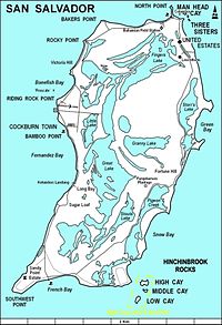
 แผนที่เกาะซานซัลวาดอร์ | |
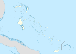
| พิกัด: 24°06′N 74°29′W / 24.100°N 74.483°W | |
| ประเทศ | |
| เกาะ | ซานซัลวาดอร์ |
| เขต | ซานซัลวาดอร์ |
| พื้นที่ | |
| • ทั้งหมด | 163 ตร.กม. (63 ตร.ไมล์) |
| ประชากร (2010) | |
| • ทั้งหมด | 930[1] คน |
| เขตเวลา | UTC-5 (Eastern Time Zone) |
| รหัสพื้นที่ | 242 |
เกาะซานซัลวาดอร์ (San Salvador Island) หรือรู้จักในชื่อ เกาะวัตลิงส์ (Watling's Island)[2] (ตั้งแต่คริสต์ทศวรรษ 1680 ถึง ค.ศ. 1925) เป็นเกาะในประเทศบาฮามาส เชื่อว่าคริสโตเฟอร์ โคลัมบัส มาจอดเรือขึ้นฝั่งเป็นครั้งแรกในการเดินทางมาสำรวจโลกใหม่ เมื่อวันที่ 12 ตุลาคม ค.ศ. 1492 เขาตั้งชื่อเกาะนี้ว่า ซานซัลวาดอร์ ตามพระคริสต์ผู้ช่วยให้รอด (Christ the Saviour)[3][4] โคลัมบัสได้บันทึกว่า ชาวลูกายัน ชนพื้นเมือง เรียกเกาะนี้ว่า Guanahani ซึ่งมีความหมายถึง "งดงามและอ่อนโยน" (sweet and gentle)[5]
อ้างอิง
[แก้]- ↑ "PRELIMINARY POPULATION AND HOUSING COUNT BY ISLAND AND SUPERVISORY DISTRICT, ALL BAHAMAS: CENSUS 2010" (PDF). Bahamas Department of Statistics. คลังข้อมูลเก่าเก็บจากแหล่งเดิม (PDF)เมื่อ 2019-11-07. สืบค้นเมื่อ 2020-04-16.
- ↑ Stark, James H. (1891). Stark's History and Guide to the Bahama Islands. Boston: Boston Photo Electrotype Co. p. 151. OCLC 1071967476.
- ↑ William D. Phillips Jr., "Columbus, Christopher", in David Buisseret (ed.), The Oxford Companion to World Exploration, (Oxford: Oxford University Press, online edition 2012).
- ↑ In 1986 the National Geographic Society made an alternative suggestion of Samana Cay. For a brief discussion of the controversy see William D. Phillips, Jr., and Carla Rahn Phillips, The Worlds of Christopher Columbus (Cambridge and New York: Cambridge University Press, 1992), pp. 155-5.
- ↑ Brown, Dee. Bury My Heart at Wounded Knee, New York: Henry Holt, p 2.

