


Digital disaster maps critical in Noto quake response and recovery
The earthquake that rocked the Noto Peninsula in Ishikawa Prefecture on Jan. 1, 2024, caused extensive damage to the area in north central Japan, resulting in both a tsunami and ground uplift along the coast. Professor Hidenori Watanave of the Interfaculty Initiative in Information Studies explains how digital maps were created and used for disaster response when people on the ground were still unable to enter the affected areas.

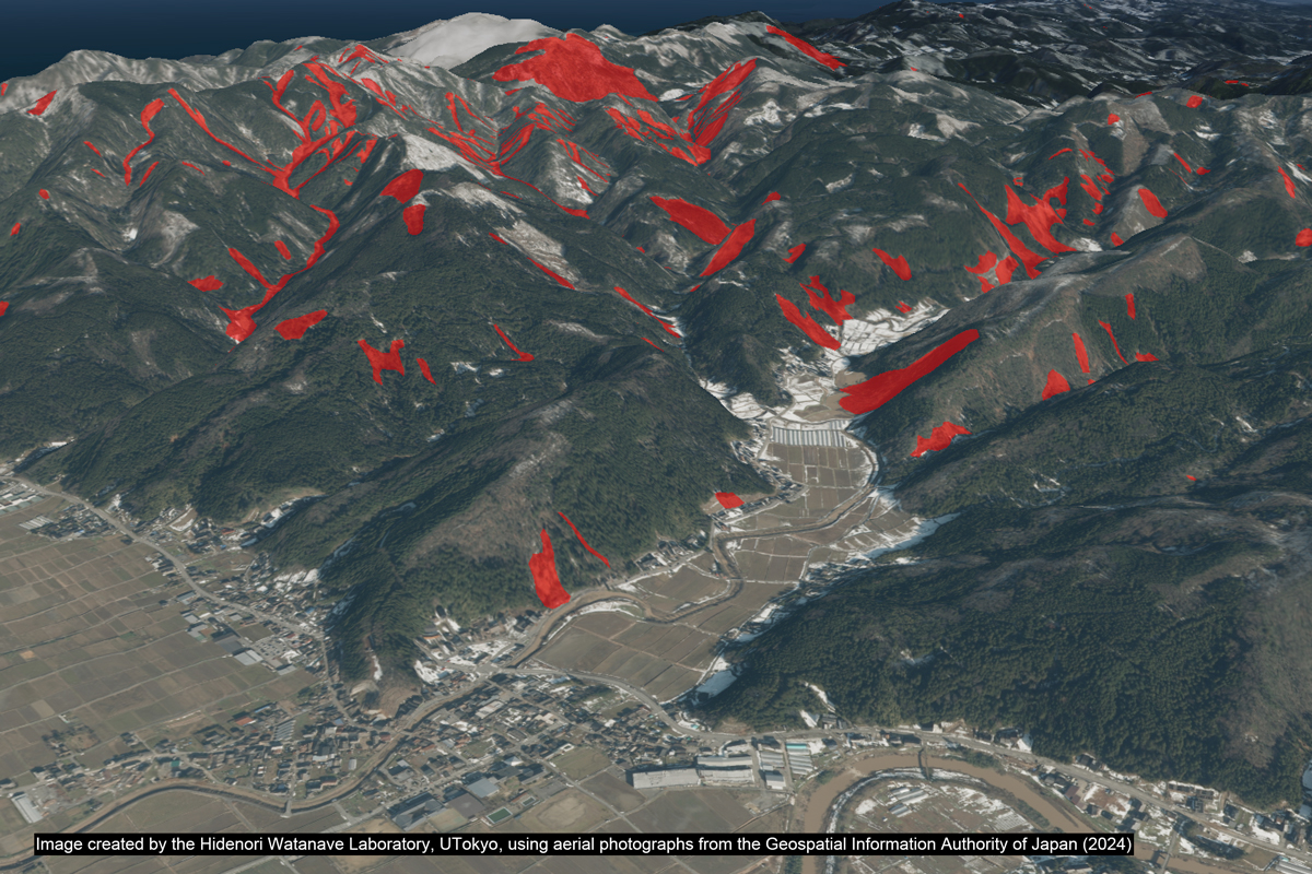
Comparison of the situation before and after the damage at the Nagahashi port on the Noto Peninsula.
── What kind of information did you send out immediately following the Noto Peninsula Earthquake?
As we demonstrated at the time of the Türkiye-Syria earthquake in February 2023, satellite imagery can be used to quickly assess the situation following a disaster. However, purchasing satellite image data of the entire Noto Peninsula would be quite costly. The Japanese government reportedly gathers information on a daily basis using satellites commissioned for this purpose, but it took three weeks for data of the Noto Peninsula to be made available. Under such circumstances, content creators, researchers and journalists scrambled to coordinate efforts and take action quickly.
The first satellite company to make imagery available to the public at no cost was Axelspace Corp., a startup headed by University of Tokyo graduates. It provided images, which were taken by satellites developed by the company, to researchers, the media and any others who expressed an interest the morning after the disaster. Using this data, I posted an image on X (the social media platform formerly called Twitter) on the evening of Jan. 2, comparing the Wajima Morning Market before and after the disaster. Although the startup’s satellites are not as sophisticated as the high-performance satellites used in Europe and the United States by companies like Maxar Technologies (whose images were used to create 3D digital maps in the aftermath of the Türkiye-Syria earthquake and of (Ukraine after the country’s invasion by Russia), the satellite imagery proved to be an invaluable source of information to quickly assess the status of fires and other critical situations while people on the ground were unable to enter the area on foot.
The next resource I used was aerial photos taken by the Geospatial Information Authority of Japan (GSI). On Jan. 3, I learned through X that Studio Duckbill, a Japan-based digital content production company, had created 3D data using GSI’s aerial photographs, so I reached out to the company immediately. In the event of a disaster, GSI takes photos by aircraft and makes them freely available. However, this is not well known by the general public, so it is hard to imagine many people deliberately visiting GSI’s website. Therefore, I decided to collaborate with Studio Duckbill to make easy-to-use, accessible digital maps available (in Japanese). My team’s previous maps, like those showing damage from the Russia-Ukraine war and the Türkiye-Syria earthquake, were made by creators using 3D data of individual buildings constructed from a terrestrial perspective, so this is the first time I used 3D data acquired from aerial photos taken over a wide area.
Piecing together 3D maps from aerial photos
── What kind of information were you able to ascertain from aerial photographs?
GSI’s aerial photos have different qualities from satellite images. Because they are taken by aircraft, they are unable to capture as wide an area as satellite images taken from space. For that reason, we started with photos covering the area around the city of Suzu and the eastern part of Wajima city, which suffered severe tsunami damage, and gradually expanded our coverage from there. Although aerial photographs pale in comparison to satellite imagery in terms of coverage, they do have a very high resolution, and when using a computer to process multiple overlapping photos taken at different angles, we can create a 3D photogrammetric model. Because the photos are taken from angles close to the ground, we get a change in the apparent direction of an object, called parallax, much like the visual effect you get when holding your finger in front of your face and comparing the viewing angle of the finger when looking at it with your left and right eyes. This is an advantage that you do not have with satellite imagery.

(For more information, refer to the NHK News story [in Japanese])
On Jan. 3, when I made the 3D map available, on-the-ground coverage by news media was still difficult, so this map became an important tool for understanding the extent of the damage. For example, in the town of Nagahashi, which is one of the communities that was cut off, we can see that the seabed in the fishing port rose as a result of crustal movement and is now above sea level (refer to image at top of the article). This makes it impossible for boats to reach the shore, or in other words, the town is no longer accessible from the sea. Estimates gauging the earthquake’s impact in the affected region indicate that at the most severe point, the uplift measures as much as 4 meters. The only road leading to the town was also hit by a massive landslide, meaning that the town was made inaccessible by land, as well. This is how many communities ended up being cut off. A number of comments online have suggested using helicopters for rescue operations, but helicopters require a certain amount of flat ground to land. Given that the topography of the Noto Peninsula is marked by many ups and downs, a 3D map of the terrain would be useful in locating such a place for landing. Our 3D map received more than 1 million page views in a single day and was used not only for the general public to understand the situation, but also for television stations to use in combination with news coverage, as well as for a variety of other purposes.
── Are the aerial photos continuing to be updated?
GSI’s aerial photos continue to be updated and I am still creating maps with them. By layering images from before and after the earthquake, it is possible to identify vulnerable areas to keep a watchful eye on in the future. For example, we can see that the areas where landslides occurred at the time of the earthquake appear completely white two weeks later due to snowfall. In spring, snowmelt could cause flash flooding or another landslide. After a major disaster like this, it is important to continue monitoring the area. This analysis was conducted in collaboration with national public broadcaster NHK (in Japanese).
Using technology to make data accessible to all
── What are some examples of how this map technology has been used so far?
I have previously created maps of damage in other countries, such as those related to the Russia-Ukraine war and the Türkiye-Syria earthquake, but the map from this earthquake has been the one most used in Japan. In Wajima, the map was used to confirm the safety of residents in the Machinomachi area. Satellite imagery and aerial photographs are two-dimensional, so at first glance, they can be difficult to understand topographically. By making 3D maps available to the public, local residents, who have knowledge of the area, can promptly send out information and contribute to disaster response efforts.
Another example is the 2024 Noto Peninsula Earthquake disaster situation map created by reporters of the Yomiuri Shimbun newspaper. Last year, we taught these reporters the equivalent of a course we offer to first- and second-year UTokyo undergraduates, within the framework of the university’s academic guidance arrangement with industry. The reporters who took this course were able to create a 3D map by compiling news photos swiftly, which they then made public on the day of the disaster. This is likely the quickest example, as news organizations scrambled to report on the major disaster occurring on New Year’s Day. The reporters’ quick response proves that people who have acquired skills through the course can create maps on their own when the situation demands it. Whatever disaster may occur in the future, they will be able to respond in the same way and put out useful content quickly. We are also talking with NHK about holding a workshop on mapping techniques for journalists as part of the comprehensive cooperation agreement between UTokyo and the broadcaster (in Japanese).
── What kind of advancements do you expect to see in the future?
After making the map available, it became difficult to respond to the flood of press coverage and interview requests, so I created a website where people can directly download the aerial photos — which I’ve listed with proper attribution — of their desired location and time. This is my message to the press to make free use of this information. Since then, it appears my content has been used in television programs and other media, and in a sense, I feel that it is starting to spread on its own without my having to intermediate each time.
In addition, as I mentioned earlier, I plan to focus on helping people acquire the skills at universities, news organizations and various other places in society. The method of creating maps by converting aerial photos into 3D data has proven useful, but this does not require any skills that are particularly difficult to learn. By making the complete method publicly available, it has become possible for anyone to create easy-to-use maps without having to rely on specific content creators, companies or governments to provide them. I hope that this system of promptly obtaining and sharing accurate information will spread throughout society, so that in the event of a disaster, everyone is able to respond quickly from the ground up.
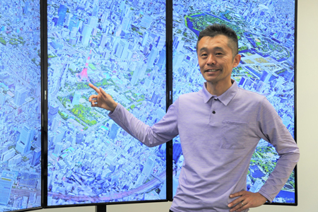
Hidenori Watanave
Professor, Interfaculty Initiative in Information Studies
Graduate of the Department of Architecture in the Faculty of Science and Technology at the Tokyo University of Science. Ph.D. in engineering from the Graduate School of Systems and Information Engineering at the University of Tsukuba. Assumed current position in 2018. Creator of Hiroshima Archive, We Shall Never Forget - Last Movements of Tsunami Disaster Victims, Battle of Okinawa Digital Archive, among other digital archives. Author and co-author of various works, including AI to Karākashita Shashin de Yomigaeru Senzen/Sensō (“Rebooting Memories of Prewar & War Through Colorized Photographs in Collaboration with AI and Human”) (Kobunsha, 2020).
Photo: Miyuki Nakajima
Interview date: Feb. 28, 2024
Interview: Yuki Terada, Hannah Dahlberg-Dodd


