Cameroon
Presidential republic
Official:
Republic of Cameroon
Local name:
Cameroun / Cameroon
Region:
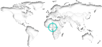
Central Africa
Surface area:
475,440 km²
Capital:
Yaounde
Geography
Cameroon is a country in Central Africa on the Gulf of Guinea. The land has a total area of 475,440 km² (183,568 mi²) and a total coastline of 402 km (249.8 mi). This land area is approximately 118% of the area of California. Cameroon is thus the 24th biggest country in Africa and in terms of area ranked 54th worldwide. More than half of all residents (59%) live within cities. Every tenth inhabitant lives in Douala alone.Cameroon lies at an average elevation of 667 meters above sea level. The highest mountain peak (Fako) is at 4,095 meters. The country has about 10 islands. There are direct national borders with the six neighboring countries Central Africa, Chad, Congo, Equatorial Guinea, Gabon and Nigeria. The distance between New York City and the Capital Yaounde is about 9,360 km (5,816 mi).
On further pages:
Current time in Cameroon:
The countrywide time in Cameroon is West Africa Time (WAT), which is currently 5 hours ahead of New York.
As in many countries, there is no daylight savings time in Cameroon.
Related to Greenwich Mean Time, there's the same difference of 1 hours all over the year.
Sunrise + Sunset00:00
September 2024
The countrywide time in Cameroon is West Africa Time (WAT), which is currently 5 hours ahead of New York.
As in many countries, there is no daylight savings time in Cameroon.
Related to Greenwich Mean Time, there's the same difference of 1 hours all over the year.
Population
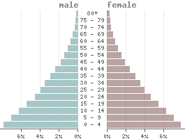
Population:28,647,000
Population per km²:60.25
Life expectancy males:Ø 59.4 years
Life expectancy females:
Ø 62.6 yearsBirth rate:
34.9 ‰Death rate:
8.2 ‰Males/Females:
49.9% : 50.1%Population pyramid
The currency in Cameroon is the cfa-franc beac (XAF).
1 Cfa-franc beac is divided into 100 Centimes.
Status: 09/02/2024
1 Cfa-franc beac is divided into 100 Centimes.
Status: 09/02/2024
1 US dollar = 593.06 Cfa-franc beacs
1000 Cfa-franc beacs = 1.69 US dollar
1000 Cfa-franc beacs = 1.69 US dollar
Climate in Cameroon
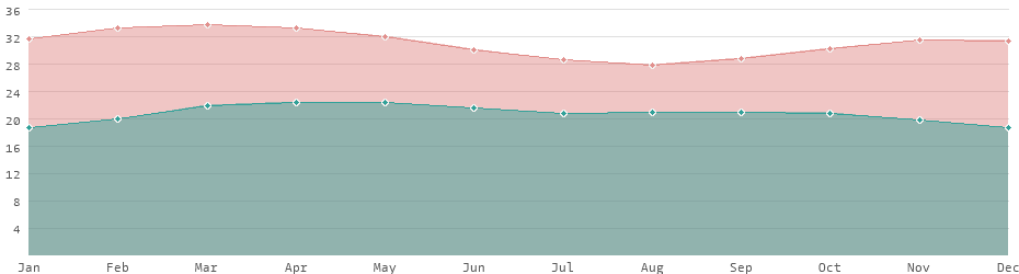
In Cameroon, as in all equatorial countries, there is a tropical climate. Unlike in Europe or the USA, there is almost no difference between the seasons. The daylight hours vary little, and the temperature differences between summer and winter are also lower. Depending on the season, the average daytime temperatures range between 28 and 34 degrees. In some parts of the country, the temperature rises to 43 °C. In the colder months, and depending in the region, the temperature drops to 19 °C in a month's average.Average daytime and nighttime temperatures
Languages
Official languages:
French, English
| Mother tongue | Distribution |
|---|---|
| Bamileke-bamum | 18.6 % |
| Duala | 10.9 % |
| Fulfulde | 9.6 % |
| Tikar | 7.4 % |
| Mandara | 5.7 % |
| Maka | 4.9 % |
| Masana | 3.9 % |
| French | 3.0 % |
| English | 2.0 % |
| Fang | 1.0 % |
| other | 33.0 % |
Religions
| Religion | Distribution |
|---|---|
| Christs | 40.0% |
| Native religions | 40.0% |
| Muslims | 20.0% |
more...
Economy
| GDP: | 47.95 bn $ |
| Exportations: | 8,641.3 M $ |
| Importations: | 9,759.0 M $ |
| › Tourism receipts: | 507.60 M $ |
| Debt rate: | 41.30 % |
| › Unemployment rate(ILOEST): | 3.65 % |
| › Inflation rate: | 7.38 % |
| › Corruption index: | 27 (very bad) |
| › Energy consumption: | 6.3 bn kWh |
Due to the critical financial situation, Cameroon is one of the heavily indebted poor countries.
With an average annual income of 1,650 USD it is one of the lower middle-income countries. Even taking purchasing power parity into account, Cameroon is still one of the poorest countries in the world.
Cameroon is considered one of the most dangerous countries worldwide.
Land use
| 1% Urban areas: | 3,680 km² |
| 21% Agricultural areas: | 98,083 km² |
| 43% Forest: | 204,582 km² |
| 1% Water areas: | 2,730 km² |
| 36% Others: | 169,094 km² |
more...
Transport
| Roadways: | 77,589 km |
| Railways: | 977 km |
| Reg. vehicles: | 467,000 |
| › Airports: |
Most important cities
Population refers to the city proper, not metropolitan areas.
| City | Region | Population |
|---|---|---|
| Yaounde / Capital | Centre | 2,766,000 |
| Douala | Littoral | 2,768,000 |
| Bamenda | North-West Province | 270,000 |
| Bafoussam | West | 239,000 |
| Garoua | North Province | 236,000 |
| Maroua | Far North | 201,000 |
| Loum | Littoral | 177,000 |
| Ngaoundéré | Adamaoua | 153,000 |
| Kumba | South-West Province | 144,000 |
| Mbouda | West | 111,000 |
| Nkongsamba | Littoral | 104,000 |
| Dschang | West | 96,000 |
| Foumban | West | 93,000 |
| Kousséri | Far North | 89,000 |
| Bertoua | East | 88,000 |
| Ébolowa | South Province | 88,000 |
| Guider | North Province | 85,000 |
| Yagoua | Far North | 80,000 |
| Mbalmayo | Centre | 80,000 |
| Meïganga | Adamaoua | 80,000 |
| Bali | North-West Province | 73,000 |
| Limbe | South-West Province | 72,000 |
| Bafia | Centre | 69,000 |
| Wum | North-West Province | 69,000 |
| Edéa | Littoral | 67,000 |
| Buea | South-West Province | 47,000 |
The difference between the urban area and the city proper alone can be considerable. Douala, for example, has an urban population of 5,768,000. However, the actual proper city is much smaller with only 1,907,000 inhabitants. The difference to metropolitan regions, i.e. conurbations with several cities, is even greater.
Political indicators
(Based on the "Worldwide Governance Indicators" project of the World Bank)
| Political stability: | ◈ |
| Rule of law: | ◈ |
| Effectivity: | ◈ |
| Regulatory quality: | ◈ |
| Voice accountability: | ◈ |
| Autocracy Index: | ◈ |
| Death penalty: | not practiced for 10+ years |
 Nigeria: country data and statistics
 List of the 36 Heavily Indebted Poor Countries
 Members of the CIS - Commonwealth of Independent States