Category:Ambae Island
Jump to navigation
Jump to search
island in the South Pacific island nation of Vanuatu   | |||||
| Upload media | |||||
| Instance of | |||||
|---|---|---|---|---|---|
| Part of |
| ||||
| Location | Penama, Vanuatu | ||||
| Located in or next to body of water | |||||
| Width |
| ||||
| Length |
| ||||
| Topographic prominence |
| ||||
| Highest point | |||||
| Population |
| ||||
| Area |
| ||||
| Elevation above sea level |
| ||||
 | |||||
Subcategories
This category has the following 6 subcategories, out of 6 total.
C
- Culture of Ambae Island (2 F)
H
- History of Ambae Island (9 F)
M
- Manaro Volcano (4 F)
S
V
- Volcanism of Ambae Island (6 F)
Media in category "Ambae Island"
The following 10 files are in this category, out of 10 total.
-
 00-323 Ambae.tif 2,694 × 1,630; 12.58 MB
-
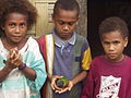 Ambae children with pet Lorikeet.jpg 1,600 × 1,200; 418 KB
-
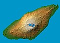 Ambae island 3D pic.jpg 1,234 × 899; 123 KB
-
 ISS006-E-40038 - View of Vanuatu.jpg 3,032 × 2,064; 733 KB
-
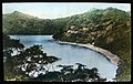
 Lolowai Bay in Ambae 1906-1.jpg 2,500 × 1,905; 1,013 KB
-
 Lolowai Bay in Ambae 1906-2 (colorized).jpg 1,503 × 949; 249 KB
-
 Lolowai Bay in Ambae 1906-2.jpg 2,500 × 1,899; 996 KB
-
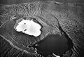
 Vanuatu - Aoba.PNG 932 × 571; 61 KB
-
 Вулкан Аоба (Вануату).jpg 640 × 409; 73 KB
-
 Вулкан Аоба.(Вануату).jpg 640 × 433; 50 KB


.jpg)

.jpg)
.jpg)
Categories:
- Islands of Vanuatu
- Penama Province
- Mountains of Vanuatu
- Active volcanoes in Vanuatu
- Calderas in Vanuatu
- Volcanic crater lakes of Vanuatu
- Volcanoes in Vanuatu
- Picro-Basalt volcanoes in Vanuatu
- Polygenetic shield volcanoes in Vanuatu
- Important Bird Areas of Vanuatu
- Pyroclastic cones in Vanuatu
- Tuff rings in Vanuatu
- Subduction volcanoes in Vanuatu
- Basalt volcanoes in Vanuatu
- Volcanoes in Vanuatu by name