Category:Gulf stream
Zur Navigation springen
Zur Suche springen
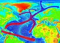
Meeresströmung im Atlantik  Le Gulf Stream (en orange et jaune) au large de la côte Est des États-Unis (température de surface) | |||||
| Medium hochladen | |||||
| Ist ein(e) | |||||
|---|---|---|---|---|---|
| Ist Teil von |
| ||||
| Benannt nach | |||||
| Liegt am oder im Gewässer | |||||
| Zeitpunkt der Entdeckung oder Erfindung |
| ||||
| Verschieden von | |||||
 | |||||
- For the aircraft manufacturer "Gulfstream" take a look at Category:Gulfstream Aerospace
Unterkategorien
Diese Kategorie enthält folgende Unterkategorie:
In Klammern die Anzahl der enthaltenen Kategorien (K), Seiten (S), Dateien (D)
I
Medien in der Kategorie „Gulf stream“
Folgende 55 Dateien sind in dieser Kategorie, von 55 insgesamt.
-

-

-
 1786-Benjamin-Franklin-Gulf-Stream-cropped.jpg 1.409 × 1.079; 304 KB
-
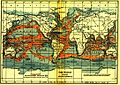
 1814 Thomson Map of the Atlantic Ocean - Geographicus - Atlantic-t-1814.jpg 5.000 × 3.990; 2,94 MB
-

-
 236 of 'Elementary Physical Geography' (11236114065).jpg 1.386 × 1.820; 569 KB
-
-

-
 A chart of the Gulf Stream inverted right to left (8475486331).jpg 800 × 610; 112 KB
-
-

-
 Antilles Current, NOAA.jpg 2.568 × 1.766; 1,7 MB
-
 Antilles Current.jpg 3.586 × 2.246; 10,74 MB
-
 Atlantic Ocean shewing the communication between Europe, and North America.png 2.863 × 1.506; 4,44 MB
-
 Bridled Tern - Seabamirum.jpg 1.857 × 1.240; 942 KB
-
 Caribbean current.png 647 × 331; 276 KB
-
Der Golfstrom - Planet Wissen.webm 1 min 41 s, 1.920 × 1.080; 76,44 MB
-
Earth Day 2020 - Gulf Stream ocean current pull out to Earth observing fleet.webm 57 s, 1.920 × 1.080; 220,37 MB
-
 Elementary physical geography (1907) (14748968056).jpg 1.484 × 1.894; 393 KB
-
 FMIB 36692 Influence du Gulf-Stream sur les Cotes de Bretagne.jpeg 1.059 × 809; 406 KB
-
 FMIB 36696 Influence du Gulf-Stream dans l'Ocean Glacial Arctique.jpeg 831 × 671; 210 KB
-
 FMIB 36722 Influence du Gulf-Stream sur le Transport des Objets Flottants.jpeg 1.136 × 826; 377 KB
-

-

-

-

-
 FMIB 43895 Current of the Gulf Stream.jpeg 2.194 × 1.537; 945 KB
-

-
-
 Franklin's chart of the Gulf Stream.jpg 642 × 404; 94 KB
-
 Franklin's first printed chart of the Gulf Stream, London 1769.jpg 3.029 × 2.392; 3,44 MB
-
 Franklin-Folger Gulf Stream chart, London, 1769 version, LOC.jpg 3.000 × 2.234; 8,64 MB
-
 Franklingulfstream.jpg 3.089 × 2.515; 1,2 MB
-
 Gervais' Beaked Whale (cropped).jpg 675 × 330; 89 KB
-
 Gervais' Beaked Whale.jpg 705 × 755; 184 KB
-
 Golf-virta.svg 934 × 690; 2,56 MB
-
 Golf-áramlat.jpg 900 × 855; 221 KB
-
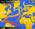 Golfstrom Karte.png 649 × 546; 142 KB
-
Golfstrom – kurzerklärt.webm 55 s, 720 × 1.280; 34,06 MB
-
 Golfstrom.jpg 363 × 363; 53 KB
-
 Gulf Stream Flowchart.gif 500 × 320; 53 KB
-
 Gulf stream map.gif 700 × 612; 222 KB
-
 Gulf Stream Surface Temperature Map.gif 540 × 360; 39 KB
-
 Gulf Stream water temperature.jpg 538 × 566; 438 KB
-
 Gulfstream.jpg 1.024 × 745; 311 KB
-
Kurzerklärt, Golfstrom - Tagesschau.webm 57 s, 1.080 × 1.350; 168,77 MB
-
 NOAA-3 Very High Resolution Radiometer (VHRR) image.jpg 1.520 × 1.184; 1,18 MB
-
 Ocean currents 1911.jpg 1.081 × 768; 1,19 MB
-
 Perpetual Ocean - Gulf Stream (7009099115).jpg 7.680 × 4.320; 29,32 MB
-
-
-
 Sargasso.png 514 × 331; 133 KB
-
 SST Gulf stream.jpeg 1.445 × 889; 539 KB
-
 Theory of the Gulf Stream (IA theoryofgulfstea00holl).pdf 795 × 1.281, 20 Seiten; 1,05 MB
-

%27_(11245149053).jpg)
%27_(11245799906).jpg)


%27_(11267992386).jpg)
.jpg)
.jpg)
)%27_(11051755973).jpg)
.jpg)
_(14594142249).jpg)


_(14748968056).jpg)


.jpg)


_image.jpg)

.jpg)
.jpg)
.jpg)


_(14596970459).jpg)