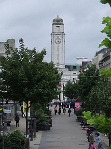
Luton
large town in Bedfordshire, England | |||||
| Upload media | |||||
| Pronunciation audio | |||||
|---|---|---|---|---|---|
| Instance of | |||||
| Location | Luton, Bedfordshire, East of England, England | ||||
| Located in or next to body of water | |||||
| Population |
| ||||
| Area |
| ||||
| Elevation above sea level |
| ||||
| official website | |||||
 | |||||
Luton is made up of 19 wards, is governed locally by Luton Borough Council, and is about 30 miles north of London. It is one of three unitary authorities in Bedfordshire. Luton was first settled in the 6th century, was granted borough status in 1876, and has a long history of millinery, manufacturing, and sport. See the subcategories for more, such as buildings, maps, parks, people and transport.
Leagrave, Limbury, Warden Hill and Wigmore were formerly independent villages and hamlets before becoming parts of Luton. There are subcategories for areas of Luton in Places in Luton.
Highlights
[edit]-
Luton Council Logo
-
Kenilworth Road, Luton Town F.C.'s stadium
-
University of Bedfordshire campus in Luton
-
A Midland Mainline Meridian (Class 222) bolts through Luton Airport Parkway
-
Thameslink train 317305 arrives at Luton Airport Parkway with an ex-LTS livery
-
Sunset over Luton
-
Tarmac seen from the terminal building at London Luton Airport
-
A straw plait stall for hatmaking
-
The north and south fronts of Luton Hoo in Bedfordshire, England as designed by Robert Adam
-
Location map of Luton in England
-
Map of Luton's 19 wards
Nearby places
[edit]This is a list of links to categories for some nearby towns and villages. Many small hamlets and villages have been absorbed by Luton as it has grown, and therefore some nearby places can be confused with Luton proper. For example, Leighton Buzzard shares a postcode with Luton, and Dunstable is often named alongside Luton as in the Luton/Dunstable Urban Area, or the Luton and Dunstable Hospital.


