Yūbari Mountains: Difference between revisions
Appearance
Content deleted Content added
Adding geodata: {{coord|43.2358|N|142.2836|E|source:wikidata|display=title}} |
Salmoonlight (talk | contribs) mNo edit summary |
||
| (9 intermediate revisions by 6 users not shown) | |||
| Line 1: | Line 1: | ||
{{Short description|Mountain range in the country of Japan}} |
|||
{{Infobox mountain |
{{Infobox mountain |
||
<!-- *** Heading *** --> |
<!-- *** Heading *** --> |
||
| name = Yubari Mountains |
| name = Yubari Mountains |
||
| native_name = |
| native_name ={{native name list |tag1=ja|name1= |
||
| other_name = |
| other_name = |
||
| category = |
|||
<!-- *** Names **** --> |
<!-- *** Names **** --> |
||
| etymology = |
| etymology = |
||
<!-- *** Image *** --> |
<!-- *** Image *** --> |
||
| photo = File:じゃがいも |
|||
| photo = |
|||
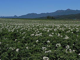
| photo_caption = Yūbari Mountains as seen from the East. Mount Ashibetsu on the Right. Potato fields in the front. |
|||
| photo_caption = |
|||
<!-- *** Country *** --> |
<!-- *** Country *** --> |
||
| country = Japan |
| country = Japan |
||
| Line 20: | Line 20: | ||
| highest = Mount Ashibetsu |
| highest = Mount Ashibetsu |
||
| elevation_m = |
| elevation_m = |
||
| coordinates = |
|||
| lat_d = | lat_m = | lat_s = | lat_NS = |
|||
| long_d = | long_m = | long_s = | long_EW = |
|||
<!-- *** Dimensions *** --> |
<!-- *** Dimensions *** --> |
||
| length_km = | length_orientation = |
| length_km = | length_orientation = |
||
| Line 33: | Line 32: | ||
| map = |
| map = |
||
| map_caption = |
| map_caption = |
||
| map_background = |
|||
| map_location = |
|||
| map_locator = |
|||
}} |
}} |
||
{{nihongo|'''Yūbari Mountains'''| |
{{nihongo|'''Yūbari Mountains'''| |
||
Part of this range is protected by the {{nihongo|[[Furano-Ashibetsu Prefectural Natural Park]]| |
Part of this range is protected by the {{nihongo|[[Furano-Ashibetsu Prefectural Natural Park]]| |
||
==Geology== |
==Geology== |
||
The Yūbari Mountains continue the |
The Yūbari Mountains continue the north–south line begun by the [[Teshio Mountains]]. The mountains are the result of the collision between the [[Kuril Islands|Kurile Island Arc]] and the [[Northeastern Japan Arc]]. Three formations make up the Yūbari mountains:<ref name="GLGarcs">{{cite web|url=http://www.glgarcs.net/intro/hkd.html|title=Hokkaido|last=Nishiwaki|first=Hirotoshi|year=2009|work=Introduction to Landforms and Geology of Japan|publisher=self-published|access-date=2009-04-21}}</ref> |
||
* Jurassic-Cretaceous formations. This forms the main ridge. It consists of [[Serpentine group|serpentine]] and rocks of the Sorachi Group. The Sorachi Group consists of [[chert]], [[greenschist]], [[micrite]] [[limestone]], and [[sandstone]] with [[felsic]] [[tuff]]. |
* Jurassic-Cretaceous formations. This forms the main ridge. It consists of [[Serpentine group|serpentine]] and rocks of the Sorachi Group. The Sorachi Group consists of [[chert]], [[greenschist]], [[micrite]] [[limestone]], and [[sandstone]] with [[felsic]] [[tuff]]. |
||
* Cretaceous forearc sediments. These rocks of the Yezo Supergroup are arranged around the Jurassic-Creaceous formations. |
* Cretaceous forearc sediments. These rocks of the Yezo Supergroup are arranged around the Jurassic-Creaceous formations. |
||
| Line 60: | Line 56: | ||
==References== |
==References== |
||
{{reflist}} |
{{reflist}} |
||
== |
|||
[http://www.pref.hokkaido.lg.jp/ks/skn/environ/parks/furano.htm Furano-Ashibetsu Prefectural Natural Park] (Japanese) - Hokkaido Government |
|||
{{coord|43.2358|N|142.2836|E|source:wikidata|display=title}} |
{{coord|43.2358|N|142.2836|E|source:wikidata|display=title}} |
||
Latest revision as of 19:30, 7 February 2024
| Yubari Mountains | |
|---|---|
 Yūbari Mountains as seen from the East. Mount Ashibetsu on the Right. Potato fields in the front. | |
| Highest point | |
| Peak | Mount Ashibetsu |
| Naming | |
| Native name | |
| Geography | |
| Country | Japan |
| State | Hokkaidō |
Yūbari Mountains (
Part of this range is protected by the Furano-Ashibetsu Prefectural Natural Park (
Geology[edit]
The Yūbari Mountains continue the north–south line begun by the Teshio Mountains. The mountains are the result of the collision between the Kurile Island Arc and the Northeastern Japan Arc. Three formations make up the Yūbari mountains:[2]
- Jurassic-Cretaceous formations. This forms the main ridge. It consists of serpentine and rocks of the Sorachi Group. The Sorachi Group consists of chert, greenschist, micrite limestone, and sandstone with felsic tuff.
- Cretaceous forearc sediments. These rocks of the Yezo Supergroup are arranged around the Jurassic-Creaceous formations.
- Paleogene formations. These rocks lie to the west of the Cretaceous sediments. The paleogene formations include seams of coal.
Peaks[edit]
- Mount Yūbari
- Mount Ashibetsu
- Mount Furano Nishi
- Mount Torumukeppu
- Mount Hattaomanai
- Mount Kirigishi
- Mount Hachimori
References[edit]
- ^
富良野 芦別 道 立 自然 公園 . Official Website of the Hokkaidō Prefectural Government (in Japanese). HOKKAIDO GOVERNMENT. 2006. Retrieved 2009-04-22. - ^ Nishiwaki, Hirotoshi (2009). "Hokkaido". Introduction to Landforms and Geology of Japan. self-published. Retrieved 2009-04-21.
外部 リンク[edit]
Furano-Ashibetsu Prefectural Natural Park (Japanese) - Hokkaido Government
