
Hattem: Difference between revisions
Shanthossi (talk | contribs) No edit summary |
|||
| (34 intermediate revisions by 24 users not shown) | |||
| Line 1: | Line 1: | ||
{{unreferenced|date=October 2011}} |
|||
{{Infobox settlement |
{{Infobox settlement |
||
<!-- See Template:Infobox settlement for additional fields and descriptions --> |
|||
| official_name = Hattem |
|||
<!-- Name and transliteration --> |
|||
| image_skyline = Hattem 275.JPG |
|||
| |
| name = Hattem |
||
| settlement_type = [[List of municipalities of the Netherlands|Municipality]] and city |
|||
| image_caption = Town hall of Hattem |
|||
<!-- Images, nickname, motto --> |
|||
| image_flag = Flag of Hattem.png |
|||
| |
| image_skyline = Hattem 275.JPG |
||
| |
| image_alt = |
||
| |
| image_caption = Hattem city hall |
||
| |
| image_flag = Hattem vlag.svg |
||
| |
| flag_size = 100x67px |
||
| flag_alt = |
|||
|latd=52|latm=28|lats=|latNS=N |
|||
| image_shield = Coat of arms of Hattem.svg |
|||
|longd=6|longm=04|longs=|longEW=E |
|||
| shield_size = 100x80px |
|||
|coordinates_display = inline,title |
|||
| shield_alt = |
|||
|coordinates_region = NL |
|||
<!-- Maps, coordinates --> |
|||
|subdivision_type = Country |
|||
| image_map = Map - NL - Municipality code 0244 (2009).svg |
|||
|subdivision_name = [[Netherlands]] |
|||
| map_alt = Highlighted position of Hattem in a municipal map of Gelderland |
|||
|subdivision_type1 = Province |
|||
| |
| map_caption = Location in Gelderland |
||
| coordinates = {{coord|52|28|N|6|4|E|region:NL|display=inline,title}} |
|||
|area_footnotes = (2006) |
|||
| coordinates_footnotes = |
|||
|area_total_km2 = 24.20 |
|||
| subdivision_type = [[List of sovereign states|Country]] |
|||
|area_land_km2 = 23.12 |
|||
| subdivision_name = [[Netherlands]] |
|||
|area_water_km2 = 1.08 |
|||
| subdivision_type1 = [[Provinces of the Netherlands|Province]] |
|||
|population_as_of = 1 January, 2010 |
|||
| subdivision_name1 = [[Gelderland]] |
|||
|population_note = Source: [[Statistics Netherlands|CBS]], [http://statline.cbs.nl/ Statline]. |
|||
| government_footnotes = <ref name="mayor_now">{{cite web |
|||
|settlement_type = Municipality |
|||
|url = http://www.hattem.nl/Bestuur_en_organisatie/College_van_B_W/Collegeleden/Burgemeester_Jan_Willem_Wiggers |
|||
|population_total = 11797 |
|||
|title = Burgemeester Jan Willem Wiggers |
|||
|population_density_km2 = 503 |
|||
|trans-title=Mayor Jan Willem Wiggers |
|||
|timezone = [[Central European Time|CET]] |
|||
| |
|language = nl |
||
|publisher = Gemeente Hattem |
|||
|timezone_DST = [[Central European Summer Time|CEST]] |
|||
|access-date = 6 July 2014 |
|||
|utc_offset_DST = +2 |
|||
|url-status = dead |
|||
|archive-url = https://web.archive.org/web/20140714191251/http://www.hattem.nl/Bestuur_en_organisatie/College_van_B_W/Collegeleden/Burgemeester_Jan_Willem_Wiggers |
|||
|archive-date = 14 July 2014 |
|||
}}</ref> |
|||
| governing_body = [[Municipal council (Netherlands)|Municipal council]] |
|||
| leader_party = [[Christian Democratic Appeal|CDA]] |
|||
| leader_title = [[Burgemeester|Mayor]] |
|||
| leader_name = [[M. (Marleen) Sanderse]] |
|||
<!-- Geographic information --> |
|||
| unit_pref = Metric |
|||
<!-- ALL fields with measurements have automatic unit conversion --> |
|||
<!-- for references: use <ref> tags --> |
|||
| area_footnotes = <ref>{{Dutch municipality total area|dataref}}</ref> |
|||
<!-- square kilometers --> |
|||
| area_total_km2 = {{Dutch municipality total area|Hattem}} |
|||
| area_land_km2 = {{Dutch municipality land area|Hattem}} |
|||
| area_water_km2 = {{Dutch municipality water area|Hattem}} |
|||
| elevation_footnotes = <ref name="AHN">{{cite web |
|||
|url = http://www.ahn.nl/postcodetool |
|||
|title = Postcodetool for 8051EZ |
|||
|language = nl |
|||
|author = <!--Staff writer(s); no by-line.--> |
|||
|work = Actueel Hoogtebestand Nederland |
|||
|publisher = Het Waterschapshuis |
|||
|access-date = 6 July 2014}}</ref> |
|||
| elevation_m = 5 |
|||
| elevation_max_footnotes = <!-- for references: use <ref> tags --> |
|||
| elevation_max_m = |
|||
| elevation_min_footnotes = <!-- for references: use <ref> tags --> |
|||
| elevation_min_m = |
|||
<!-- Population, demographics --> |
|||
| population_footnotes = <ref>{{Dutch municipality population|dataref}}</ref> |
|||
| population_total = 12.569 |
|||
| population_as_of = 2023 |
|||
| population_density_km2 = 545 |
|||
| population_demonym = Hattemer |
|||
<!-- Other information --> |
|||
| timezone = [[Central European Time|CET]] |
|||
| utc_offset = +1 |
|||
| timezone_DST = [[Central European Summer Time|CEST]] |
|||
| utc_offset_DST = +2 |
|||
| postal_code_type = [[Postal codes in the Netherlands|Postcode]] |
|||
| postal_code = 8050–8052 |
|||
| area_code_type = [[Telephone numbers in the Netherlands|Area code]] |
|||
| area_code = 038 |
|||
| website = {{URL|1=http://www.hattem.nl}} |
|||
| footnotes = |
|||
}} |
}} |
||
'''Hattem''' ({{IPA-nl|ˈɦɑtəm|-|Nl-Hattem.ogg}}) is a [[Municipalities of the Netherlands|municipality]] and a town in the eastern [[Netherlands]]. The municipality had a population of {{formatnum:{{Dutch municipality population|Hattem}}}} in {{YEAR|{{Dutch municipality population|popbaseyear}}}}. The municipality includes the hamlet of [['t Zand (Hattem)|'t Zand]]. |
|||
[[Image:2013-Hattem.jpg|{{largethumb}}|Dutch Topographic map of Hattem, July 2013]] |
|||
'''Hattem''' ({{pronunciation|Nl-Hattem.ogg}}) is a [[municipality]] and a city in the eastern [[Netherlands]]. The city population is 11,797. (1 jan. 2010) The municipality includes the hamlet of [['t Zand (Hattem)|'t Zand]]. |
|||
==Name origin== |
==Name origin== |
||
[[File:Gem-Hattem-OpenTopo.jpg|thumb|left|Dutch Topographic map of Hattem, June 2015]] |
|||
The name “Hattem” is a typical farmyard name. The exact origin of “Hattem” is yet unclear. In general two explanation exist. Hattem would be the ‘heem’ (home) of a people who belong to the tribe of Chattuarii (or Hattuarii or Hatten). A second origin could refer to the leader of a people under the leader Hatto. This fits with the fact that a lot of farmyard names are deduced from persons names. |
The name “Hattem” is a typical farmyard name. The exact origin of “Hattem” is yet unclear. In general two explanation exist. Hattem would be the ‘heem’ (home) of a people who belong to the tribe of Chattuarii (or Hattuarii or Hatten). A second origin could refer to the leader of a people under the leader Hatto. This fits with the fact that a lot of farmyard names are deduced from persons names. |
||
| Line 43: | Line 89: | ||
===Established as parish=== |
===Established as parish=== |
||
Despite this early statement, no church or chapel was built in Hattem. In 1176 Hattem became a parish (‘kerspel’). The chapel, measuring 17,5 by 9,5 meter, was not built at the current city centre, but at the Gaedsberg (‘Gods-mountain’). The borders of the parish coincide with the latter borders of the jurisdiction Hattem. Hattem obtained [[City rights in the Netherlands|city rights]] in 1299 from the landgrave Reinoud I van Gelre. In the decades before a fortified town is founded at the northern border of the Veluwe. The city plan lies around the current church. The tower of this church is dated to the 12th century which indicates that, |
Despite this early statement, no church or chapel was built in Hattem. In 1176 Hattem became a parish (‘kerspel’). The chapel, measuring 17,5 by 9,5 meter, was not built at the current city centre, but at the Gaedsberg (‘Gods-mountain’). The borders of the parish coincide with the latter borders of the jurisdiction Hattem. Hattem obtained [[City rights in the Netherlands|city rights]] in 1299 from the landgrave Reinoud I van Gelre. In the decades before a fortified town is founded at the northern border of the Veluwe. The city plan lies around the current church. The tower of this church is dated to the 12th century which indicates that, beside the parish church at the Gaedsberg, a chapel was present at the current city centre of Hattem. With obtaining town privileges, both the religious and the legal centre were moved. The new church and the city are dedicated to the apostle Andreas. |
||
===Later history=== |
===Later history=== |
||
[[File:Zicht op de 'Spaanse Graven', schanswerk uit de 80-jarige oorlog - Hattem - 20535668 - RCE.jpg|thumbnail |
[[File:Zicht op de 'Spaanse Graven', schanswerk uit de 80-jarige oorlog - Hattem - 20535668 - RCE.jpg|thumbnail|View of the 'Spanish Trenches', ramp work from the [[Eighty Years' War]]]] |
||
In 1401, duke [[William I of Guelders and Jülich|William of Guelders]] donated the Hoenwaard to the citizens of Hattem, in order to feed their cattle and to manufacture bricks for their houses. In 1404 the castle St. Lucia was built, which became known as the “Dikke Tinne” (the fat merlon). The reason can be found in the thick castle walls, at that time the thickest walls found in the Netherlands. In 1778, the castle was torn down, in order to use the bricks to build houses. In 1786, both Hattem and Elburg became known as centres of the [[ |
In 1401, duke [[William I of Guelders and Jülich|William of Guelders]] donated the Hoenwaard to the citizens of Hattem, in order to feed their cattle and to manufacture bricks for their houses. In 1404 the castle St. Lucia was built, which became known as the “Dikke Tinne” (the fat merlon). The reason can be found in the thick castle walls, at that time the thickest walls found in the Netherlands. In 1778, the castle was torn down, in order to use the bricks to build houses. In 1786, both Hattem and Elburg became known as centres of the [[Patriottentijd]], a political faction. These movements however were successfully suppressed by [[William V, Prince of Orange|stadtholder William V]]. |
||
==Other information== |
==Other information== |
||
Hattem had a railway station from 21 November 1887 until 8 |
Hattem had a railway station from 21 November 1887 until 8 October 1950. |
||
The current mayor of Hattem is |
The current mayor of Hattem is Marleen Sanderse ([[Christen Democratisch Appèl|CDA]]). |
||
Hattem, bordering the forests of ‘[[De Veluwe]]’ and along the [[IJssel]] river has much to offer: cosy terraces, interesting museums, a large variety of authentic shops an annually returning events. Hattem celebrates ''De dikke tinne festival'' every two years in a medieval atmosphere. |
Hattem, bordering the forests of ‘[[De Veluwe]]’ and along the [[IJssel]] river has much to offer: cosy terraces, interesting museums, a large variety of authentic shops an annually returning events. Hattem celebrates ''De dikke tinne festival'' every two years in a medieval atmosphere. |
||
== Notable |
== Notable residents == |
||
[[File:Posthumous Portrait of Herman Willem Daendels, Governor-General of the Dutch East Indies - Rd Saleh.jpg|125px|thumb|Posthumous Portrait of Herman Willem Daendels]] |
|||
* [[John III of Egmont]] (1438–1516) first Count of Egmont and [[Stadtholder]] of Holland, Zeeland and West-Friesland |
|||
* [[Herman Willem Daendels]] (1762-1818), Dutch politician. |
|||
* [[Herman Willem Daendels]] (1762-1818), Dutch politician, 36th [[Governor-General of the Dutch East Indies]], 1808 to 1811 |
|||
* [[Jan Voerman]] (1857–1941) a Dutch painter |
|||
* [[Luite Klaver]] (1870–1960) a Dutch painter, lithographer and inventor |
|||
* [[Willem Jacob van Stockum]] (1910–1944) a mathematician, contributed to [[general relativity]] |
|||
* [[Henri Wassenbergh]] (1924-2014) a Dutch academic, professor of law, and writer |
|||
* [[Robert Long (singer)|Robert Long]] (1943-2006) a Dutch singer and television presenter |
|||
* [[Ellen Spijkstra]] (born 1957) Dutch ceramic artist and photographer |
|||
=== Sport === |
|||
* [[Jan van Raalte]] (born 1968) a football manager and former professional player with 324 club caps |
|||
* [[Ellen Kuipers]] (born 1971) a former field hockey forward, team bronze medallist at the [[1996 Summer Olympics]] |
|||
== Sightseeing == |
== Sightseeing == |
||
{{columns-list|colwidth=12em| |
|||
* [[Anton Pieck Museum]] |
|||
* [[ |
* [[Anton Pieck]] Museum |
||
* Voerman Museum Hattem |
|||
* [[Bakkerij]]museum |
|||
* Bakkerij museum |
|||
* [[Concertzaal]] [[Olde Skoele|D'Olde Skoele]] |
|||
* |
* Dijkpoort town gate |
||
* |
* windmill De Fortuin |
||
* De [[Grote of Andreaskerk (Hattem)|Grote of Andreaskerk]] |
* De [[Grote of Andreaskerk (Hattem)|Grote of Andreaskerk]] main church |
||
}} |
|||
== Gallery == |
|||
<gallery perrow=4> |
|||
<gallery mode=packed> |
|||
Image:Hattem_kerk.jpg|Church of Hattem |
Image:Hattem_kerk.jpg|Church of Hattem |
||
Image:Hattem, de Dijkpoort RM20937 foto2 2013-07-15 17.15.jpg|Hattem, town-gate ''de Dijkpoort'' |
Image:Hattem, de Dijkpoort RM20937 foto2 2013-07-15 17.15.jpg|Hattem, town-gate ''de Dijkpoort'' |
||
Image:Windmolen Hattem.jpg|Windmill ''De Fortuin'' |
|||
Image:2007-04-23 11.10 Hattem, monumentaal horecapand.JPG|House of [[Herman Willem Daendels]] |
Image:2007-04-23 11.10 Hattem, monumentaal horecapand.JPG|House of [[Herman Willem Daendels]] |
||
Image:Hattem 267.JPG |
Image:Hattem 267.JPG|het Warme Land |
||
Image:Hattem 271.JPG |
Image:Hattem 271.JPG|Kerkhofstraat |
||
Image:Windmolen Hattem.jpg|Windmill ''De Fortuin'' |
|||
Image:Hattem 255.JPG |
|||
File:Monding van het Apeldoorns Kanaal in de IJssel bij Hattem - Hattem - 20359846 - RCE.jpg|Monding van het Apeldoorns Kanaal in de IJssel bij Hattem - Hattem |
|||
File:Hattem, Netherlands - panoramio (21).jpg|Hattem |
|||
Image:Hattem 252.JPG|Citywall at the level of the Daendelspoortje |
Image:Hattem 252.JPG|Citywall at the level of the Daendelspoortje |
||
</gallery> |
</gallery> |
||
==References== |
|||
{{Reflist|30em}} |
|||
==External links== |
==External links== |
||
{{Commons category}} |
*{{Commons category-inline}} |
||
*[http://www.hattem.nl Official website] |
*[http://www.hattem.nl Official website] |
||
*[https://jck.nl/en/page/hattem Hattem Synagogue] |
|||
*[http://www.ronduithattem.nl Tourist information] {{nl icon}} |
|||
*[http://www.hanzesteden.info Hanseatic Cities Holland] |
|||
{{Geographic location |
{{Geographic location |
||
| Line 96: | Line 156: | ||
{{Hanseatic League}} |
{{Hanseatic League}} |
||
{{Gelderland Province}} |
{{Gelderland Province}} |
||
{{Authority control}} |
|||
[[Category:Hattem| ]] |
|||
[[Category:Municipalities of Gelderland]] |
[[Category:Municipalities of Gelderland]] |
||
[[Category:Populated places in Gelderland]] |
[[Category:Populated places in Gelderland]] |
||
[[Category: |
[[Category:Cities in the Netherlands]] |
||
[[Category:Members of the Hanseatic League]] |
|||
Latest revision as of 19:06, 14 February 2024
Hattem | |
|---|---|
Municipality and city | |
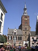
 Hattem city hall | |
 Flag  Coat of arms | |
.svg) Location in Gelderland | |
| Coordinates: 52°28′N 6°4′E / 52.467°N 6.067°E | |
| Country | Netherlands |
| Province | Gelderland |
| Government | |
| • Body | Municipal council |
| • Mayor | M. (Marleen) Sanderse (CDA) |
| Area | |
| • Total | 24.16 km2 (9.33 sq mi) |
| • Land | 23.08 km2 (8.91 sq mi) |
| • Water | 1.08 km2 (0.42 sq mi) |
| Elevation | 5 m (16 ft) |
| Population (2023)[4] | |
| • Total | 12.569 |
| • Density | 545/km2 (1,410/sq mi) |
| Demonym | Hattemer |
| Time zone | UTC+1 (CET) |
| • Summer (DST) | UTC+2 (CEST) |
| Postcode | 8050–8052 |
| Area code | 038 |
| Website | www |
Hattem (Dutch pronunciation: [ˈɦɑtəm] ) is a municipality and a town in the eastern Netherlands. The municipality had a population of 12,228 in 2021. The municipality includes the hamlet of 't Zand.
Name origin[edit]

The name “Hattem” is a typical farmyard name. The exact origin of “Hattem” is yet unclear. In general two explanation exist. Hattem would be the ‘heem’ (home) of a people who belong to the tribe of Chattuarii (or Hattuarii or Hatten). A second origin could refer to the leader of a people under the leader Hatto. This fits with the fact that a lot of farmyard names are deduced from persons names.
History[edit]
A document referring to Hattem is found is dated around 800. This document is the Codex Laureshamensis, in which the settlement Hattem is mentioned because two farmhouses in this place are donated to the Lorsch abbey.
Established as parish[edit]
Despite this early statement, no church or chapel was built in Hattem. In 1176 Hattem became a parish (‘kerspel’). The chapel, measuring 17,5 by 9,5 meter, was not built at the current city centre, but at the Gaedsberg (‘Gods-mountain’). The borders of the parish coincide with the latter borders of the jurisdiction Hattem. Hattem obtained city rights in 1299 from the landgrave Reinoud I van Gelre. In the decades before a fortified town is founded at the northern border of the Veluwe. The city plan lies around the current church. The tower of this church is dated to the 12th century which indicates that, beside the parish church at the Gaedsberg, a chapel was present at the current city centre of Hattem. With obtaining town privileges, both the religious and the legal centre were moved. The new church and the city are dedicated to the apostle Andreas.
Later history[edit]

In 1401, duke William of Guelders donated the Hoenwaard to the citizens of Hattem, in order to feed their cattle and to manufacture bricks for their houses. In 1404 the castle St. Lucia was built, which became known as the “Dikke Tinne” (the fat merlon). The reason can be found in the thick castle walls, at that time the thickest walls found in the Netherlands. In 1778, the castle was torn down, in order to use the bricks to build houses. In 1786, both Hattem and Elburg became known as centres of the Patriottentijd, a political faction. These movements however were successfully suppressed by stadtholder William V.
Other information[edit]
Hattem had a railway station from 21 November 1887 until 8 October 1950.
The current mayor of Hattem is Marleen Sanderse (CDA).
Hattem, bordering the forests of ‘De Veluwe’ and along the IJssel river has much to offer: cosy terraces, interesting museums, a large variety of authentic shops an annually returning events. Hattem celebrates De dikke tinne festival every two years in a medieval atmosphere.
Notable residents[edit]

- John III of Egmont (1438–1516) first Count of Egmont and Stadtholder of Holland, Zeeland and West-Friesland
- Herman Willem Daendels (1762-1818), Dutch politician, 36th Governor-General of the Dutch East Indies, 1808 to 1811
- Jan Voerman (1857–1941) a Dutch painter
- Luite Klaver (1870–1960) a Dutch painter, lithographer and inventor
- Willem Jacob van Stockum (1910–1944) a mathematician, contributed to general relativity
- Henri Wassenbergh (1924-2014) a Dutch academic, professor of law, and writer
- Robert Long (1943-2006) a Dutch singer and television presenter
- Ellen Spijkstra (born 1957) Dutch ceramic artist and photographer
Sport[edit]
- Jan van Raalte (born 1968) a football manager and former professional player with 324 club caps
- Ellen Kuipers (born 1971) a former field hockey forward, team bronze medallist at the 1996 Summer Olympics
Sightseeing[edit]
- Anton Pieck Museum
- Voerman Museum Hattem
- Bakkerij museum
- Dijkpoort town gate
- windmill De Fortuin
- De Grote of Andreaskerk main church
Gallery[edit]
-
 Church of Hattem
 -
 Hattem, town-gate de Dijkpoort
 -
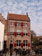 House of Herman Willem Daendels
 -
 het Warme Land
 -
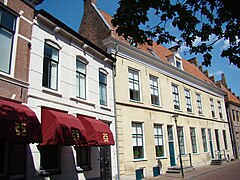 Kerkhofstraat
 -
 Windmill De Fortuin
 -
 Monding van het Apeldoorns Kanaal in de IJssel bij Hattem - Hattem
 -
 Hattem
 -
 Citywall at the level of the Daendelspoortje


.jpg)

References[edit]
- ^ "Burgemeester Jan Willem Wiggers" [Mayor Jan Willem Wiggers] (in Dutch). Gemeente Hattem. Archived from the original on 14 July 2014. Retrieved 6 July 2014.
- ^ "Kerncijfers wijken en buurten 2020" [Key figures for neighbourhoods 2020]. StatLine (in Dutch). CBS. 24 July 2020. Retrieved 19 September 2020.
- ^ "Postcodetool for 8051EZ". Actueel Hoogtebestand Nederland (in Dutch). Het Waterschapshuis. Retrieved 6 July 2014.
- ^ "Bevolkingsontwikkeling; regio per maand" [Population growth; regions per month]. CBS Statline (in Dutch). CBS. 1 January 2021. Retrieved 2 January 2022.
External links[edit]
 Media related to Hattem at Wikimedia Commons
- Official website
- Hattem Synagogue
Members of the Hanseatic League by quarter, and trading posts of the Hanseatic League | ||||
|---|---|---|---|---|
| ||||
| Wendish |
|   | ||
| Saxon | ||||
| Baltic | ||||
| Westphalian | ||||
| Kontore | ||||
| Vitten | ||||
| Factories | ||||

| International | |
|---|---|
| National | |
| Geographic | |