
Goring Gap: Difference between revisions
→Gallery: template for panoramic photo |
Rearrangement of article using previous material as a base, with the addition of new material and references throughout. |
||
| Line 1: | Line 1: | ||
{{Short description|River Thames valley in south east England}} |
|||
{{Use dmy dates|date=March 2017}} |
|||
{{Use British English|date=March 2017}} |
|||
{{Distinguish|text = the protected gap between [[Goring-by-Sea]] and [[Ferring]]}} |
|||
The '''Goring Gap''' is one of the most singular topographical features along the 346-kilometre length of the [[River Thames]], which itself is the longest river entirely in England. The Gap is located in southern England where the river, flowing from north to south, cuts through and crosses a line of chalk hills in a relatively narrow gap between the [[Chiltern Hills]] and the [[Berkshire Downs]]. The Gap is approximately {{convert|10|mi}} upstream of [[Reading, Berkshire|Reading]] and {{convert|27|mi}} downstream of [[Oxford]]. The Gap is named after the town of [[Goring-on-Thames]] in Oxfordshire. That town is on the east bank of the river at Goring Gap, and [[Streatley, Berkshire|Streatley]] (in Berkshire) is immediately opposite, on the west bank. |
|||
At Goring Gap, the Thames is at an altitude of about 45 metres. The ground rises steeply on either side, reaching 100 metres within a kilometre to the east and west, and continuing to higher ground at around 160 metres. |
|||
The [[Chalk]] beds have proved to be relatively more resistant to erosion than adjacent geological formations, so the relief of land to the north and south-east of the Gap is less marked. In particular, there is a low-lying [[Gault]] clay vale either side of [[Dorchester on Thames|Dorchester]] (to the north), and a broad, low-lying [[London Clay]] zone in the [[London Basin]] beyond Reading (to the south-east). |
|||
Although this configuration - of a major river slicing through chalk hills, with extensive areas of lower-lying land on either side - is not found in this precise fashion elsewhere in the Chiltern Hills, it is found at a number of locations in the [[North Downs]] and [[South Downs]]; for example, where the North Downs are crossed by the [[River Wey]] at [[Guildford]], and by the [[River Mole]] near [[Dorking]]. |
|||
[[File:Goring Gap location map and catchment area.jpg|thumb| upright=3|center|alt=Goring Gap and thames catchment area.|]] |
|||
==Formation== |
|||
The River Thames has its origins in the emergence of Britain from a [[Cretaceous]] sea over 60 million years ago. During the latter part of the Cretaceous period, sea level is thought to have been over 150 metres higher than today. |
|||
<ref>[https://news.mongabay.com/2008/03/cretaceous-sea-levels-were-550-feet-higher-than-today/#:~:text=Sea%20levels%20were%20550%20feet%20%28170%20m%29%20higher%20in%20the,published%20in%20the%20journal%20Science%2E ''Cretaceous sea levels were 550 feet higher than today''], at mongabay.com.</ref> |
|||
Much of the land which was later to form Britain was covered by sea. In this marine environment, thick deposits of Chalk were laid down. |
|||
From the early [[Paleocene]] (from around 65 million years ago), much of what is now Britain emerged above sea level. The maximum uplift occurred in the north-west, with a regional tilt towards the east and south-east. The [[North Sea]] basin also developed. |
|||
<ref>Gibbard, P.L. & Lewin, J., 2003 ("'''Gibbard & Lewin 2003'''"), ''The history of the major rivers of southern Britain during the Tertiary'', Journal of the Geological Society, 160, pages 829-845. ''Tectonic map'' and ''Palaeocene'' sections. Online at [https://www.qpg.geog.cam.ac.uk/research/projects/tertiaryrivers/ www.qpg.geog.cam.ac.uk].</ref><ref>{{Cite journal|url = https://pubs.bgs.ac.uk/publications.html?pubID=B03234|title = THE GEOLOGY OF THE THAMES VALLEY NEAR GORING, as illustrated by the Model in the Museum of Practical Geology.|last = Sir A. STRAHAN, K.B.E., F.R.S.|date = 1924|journal = Reports & Proceedings—Geologists Association. Mem. Geol. Surv.| volume=63 | issue=1 | pages=43 |access-date = 2024-01-17}}</ref> |
|||
The drainage of much of England was thus aligned to the south-east. As the land emerged from beneath the Cretaceous sea, precursors of some of today's major drainage systems of central, eastern and southern England developed. Thus, from the early [[Tertiary]] period a number of major [[Fluvial_landforms_of_streams|consequent rivers]] flowed approximately NW-SE down the tilted emergent Chalk surface towards what later became southern England. |
|||
One of those early watercourses was the [[Ancestral Thames]]. However, the course of the river prior to the [[Pleistocene]] epoch is not known exactly. The geological beds over which it flowed (including Chalk beds which formerly covered much of central, northern and western Britain), and any deposits which the river may have left, have all been removed by erosion. |
|||
However, it is known with some certainty that the Thames has been flowing close to where the Goring Gap is now situated from at least Early Pleistocene times - that is, for at least one million years, and probably for rather longer. This is because a deposit of "variably sandy and clayey gravel", which is known to have been laid down by the Thames, has been found on hilltops close to Goring Gap.<ref>[https://webapps.bgs.ac.uk/lexicon/lexicon.cfm?pub=WGGR ''Westland Green Gravel Member''], British Geological Survey Lexicon of Named Rock Units, at webapps.bgs.ac.uk.</ref> This deposit, known as Westland Green Gravel, lies on land at a today's altitude of about 160 metres at Cray's Pond (about three kilometres east of Goring), and at the top of Streatley Hill (about one kilometre west of today's Thames).<ref name=Gibbard-85>Gibbard, P.L. (1985) ("'''Gibbard 1985'''"), ''The Pleistocene history of the Middle Thames Valley'', Cambridge University Press.</ref><ref>[https://geologyviewer.bgs.ac.uk/ BGS Geology Viewer], British Geological Survey, at geologyviewer.bgs.ac.uk.</ref><ref>However, the Westland Green Gravel may have been laid down at a lower altitude relative to sea level at that time, because "... early Pleistocene uplift of western and north-western Britain caused a relative displacement of c.180m between the western London Basin and the Suffolk coast" - Gibbard & Lewin 2003, ''Neogene (Miocene and Pliocene)'' sections.</ref> It is believed that that deposit was laid down by the Thames approximately 1.6 million years ago.<ref>Lee, J.R., Rose J. and others, 2011 ("'''Lee and others 2011'''"), ''The Glacial History of the British Isles during the Early and Middle Pleistocene: Implications for the long-term development of the British Ice Sheet'', pages 59-74 in ''Quaternary Glaciations - Extent and Chronology, a Closer Look''. Developments in Quaternary Science, 15, (Amsterdam: Elsevier). On page 63, the "Westland Green terrace" is "tentatively assigned" to [[Marine isotope stages|Marine Isotope Stages]] 62-54 (1.75Ma - 1.6Ma). See the chart at [http://quaternary.stratigraphy.org/charts/version-history/ quaternary.stratigraphy.org]</ref> |
|||
[[File:Thames and Goring Gap location map.jpg|thumb| upright=3|center|alt=Goring Gap and Thames between Oxford and Reading.|]] |
|||
(It is possible that, at a slightly earlier time (on a geological scale), the Thames may have been flowing on a course a little to the north-east of Goring Gap - that is, through Stoke Row, where deposits laid down by the Thames and resting today at a somewhat higher altitude (over 170 metres) have been identified.<ref name=Gibbard-85 /> The outcrops of Thames gravel there are relatively isolated, and the line which the river was taking at that time is not entirely clear. But if the Thames did enter the London Basin in the vicinity of Stoke Row at that time, it would then have moved south-westwards to Goring Gap over a period of about a hundred thousand years or more, prior to the deposit of the Westland Green Gravel.<ref>Lee and others 2011, page 63. There, the "Stoke Row terrace" is "tentatively assigned" to Marine Isotope Stage 68 - that is, around 1.8 million years ago.</ref><ref>It is also possible that, at an even earlier time during the Early Pleistocene, the Thames flowed further north-east, through where Nettlebed is now located. Deposits of "gravel with a sandy matrix", which may have been laid down by the Thames, have been found there, at an altitude of just over 200 metres. See Gibbard 1985, page 8. However, doubt has been cast upon the Thames origin of these deposits. See: Peter Worsley, 2016, ''A reconsideration of the origin of the early Pleistocene ‘Pebble Gravel Formation’ at Nettlebed, Oxfordshire, south central England'', Proceedings of the Geologists’ Association, 127, 445–450; partly online at [https://www.sciencedirect.com/science/article/abs/pii/S001678781630058X www.sciencedirect.com]. See also: [https://rdnhs.org.uk/blog/geology-at-nettlebed-4-december-2021 Geology at Nettlebed], Reading and District Natural History Society, December 2021.</ref>) |
|||
[[File:Ancestral Thames Early Pleistocene.jpg|thumb|Ancestral Thames - Early Pleistocene.]] |
|||
The Stoke Row Gravel and the Westland Green Gravel are known to have been deposited by a major watercourse because they contain far-travelled materials, such as quartz and quartzite from Triassic and earlier formations of the West Midlands, and volcanic rocks from northern Wales. Moreover, the Westland Green Gravel continues beyond Goring Gap, north-eastwards across Hertfordshire and into East Anglia.<ref>The name "Westland Green Gravel" was first proposed in Hey, R.W., 1965, ''Highly quartzose pebble gravels in the London Basin'', Proc. Geol. Ass., 76, 403-20. Westland Green is a location in Hertfordshire near [[Bishop's Stortford]] where an outcrop of this formation was identified by Hey.</ref> A watercourse of such magnitude could only have been a precursor of today's River Thames.<ref>Bridgland, D.R. (1994, 2012) ("'''Bridgland 1994'''"), ''Quaternary of the Thames'', Geological Conservation Review Series, Springer Science & Business Media, ISBN 978-94-010-4303-8, ISBN 978-94-011-0705-1 (eBook) (originally published by Chapman and Hall). "...there is abundant evidence to show that the modern Thames is a mere shadow of its Pleistocene forebear. Not only did it once flow from the London Basin out across East Anglia to north Norfolk, but there are indications that its headwaters may once have drained a large part of the West Midlands and even North Wales" (from chapter 1).</ref> |
|||
The extent and course of the Thames have changed considerably in certain places during the past 1.5 million years. In particular, the Thames lost its headwaters north of the Cotswolds - possibly as a result of the Anglian glaciation about 450,000 years ago.<ref>Gibbard 1985, page 135; and Gibbard P.L., Turner C., West R.G., 2013, ''The Bytham river reconsidered'', Quaternary International, 292, pages 15-32.</ref> That glaciation was certainly responsible for a major change in the river's course in the London Basin, where the ice advance to [[Watford]] forced the river, which had formerly flowed along the line of the Vale of [[St Albans]], to take a more southerly course towards the North Sea, approximately along its present line.<ref>Bridgland 1994, chapter 1, "The diversion of the Thames".</ref> |
|||
[[File:Goring Gap contour map.jpg|thumb|]] |
|||
However, the course of the Thames in the vicinity of Goring Gap has stayed much the same during the past 1.5 million years. Deposits laid down by the Thames which are younger than the Westland Green Gravel are found on hillsides close to today's Thames in a zone running from Goring Gap to Reading, with their altitude becoming lower as the deposits become younger.<ref name=Gibbard-85 /> And ice sheets from the north never reached as far south as Goring, so they did not disrupt the river's course here as they did elsewhere. The river at Goring Gap has simply cut down progressively to its current altitude. During that time, the relief in the vicinity of Goring Gap, as elsewhere in many parts of Britain, has become progressively more pronounced, especially at times during the [[Quaternary]] of "high discharge, under cold climatic conditions".<ref>Bridgland 1994, chapter 1, "Terrace Formation".</ref> |
|||
<!-- |
|||
***************** |
|||
'''Goring Gap Wiki page content to 2024-01-16''': |
|||
{{Short description|River Thames valley in south east England}} |
{{Short description|River Thames valley in south east England}} |
||
{{Use dmy dates|date=March 2017}} |
{{Use dmy dates|date=March 2017}} |
||
| Line 14: | Line 60: | ||
| height = 250 |
| height = 250 |
||
| float = right |
| float = right |
||
| annotations = |
| annotations = |
||
| caption = Elevation: slope map with the Goring Gap in the southwest (bottom left) between the white hills. Click for broader map and to enable varied magnification. |
| caption = Elevation: slope map with the Goring Gap in the southwest (bottom left) between the white hills. Click for broader map and to enable varied magnification. |
||
}} |
}} |
||
| Line 20: | Line 66: | ||
Since the ice sheets receded, the Thames has continued its new course – that is, one through Berkshire, to soon meet the [[River Kennet]] which had already carved out the lower Thames valley.<ref name=icgg>{{cite web | url = http://www3.imperial.ac.uk/portal/pls/portallive/docs/1/587934.PDF | title = Geology and Soils | publisher = Imperial College | author = Michael J Crawley | access-date = 21 March 2007 | archive-url = https://web.archive.org/web/20070630151108/http://www3.imperial.ac.uk/portal/pls/portallive/docs/1/587934.PDF | archive-date = 30 June 2007 | url-status = dead}}</ref> |
Since the ice sheets receded, the Thames has continued its new course – that is, one through Berkshire, to soon meet the [[River Kennet]] which had already carved out the lower Thames valley.<ref name=icgg>{{cite web | url = http://www3.imperial.ac.uk/portal/pls/portallive/docs/1/587934.PDF | title = Geology and Soils | publisher = Imperial College | author = Michael J Crawley | access-date = 21 March 2007 | archive-url = https://web.archive.org/web/20070630151108/http://www3.imperial.ac.uk/portal/pls/portallive/docs/1/587934.PDF | archive-date = 30 June 2007 | url-status = dead}}</ref> |
||
--> |
|||
==Communications== |
|||
==Context and localities== |
|||
<!-- |
|||
The Goring Gap constricts the Thames, narrowing the otherwise broad valley. Downstream lower hills almost face each other at [[Henley-on-Thames]]. |
The Goring Gap constricts the Thames, narrowing the otherwise broad valley. Downstream lower hills almost face each other at [[Henley-on-Thames]]. |
||
Steep hills rise southwards to [[Lardon Chase, the Holies and Lough Down|Lardon Chase]], the nearest section of the Berkshire Downs while the [[Chiltern Hills]] rise to the north. The twin villages of Goring and [[Streatley, Berkshire|Streatley]] face each other at the heart of the gap.<ref>{{Cite web|title = GEOGRAPHY & GEOLOGY|url = http://www.visitgoringandstreatley.co.uk/geography--geology.html|website = Visit Goring and Streatley|access-date = 2016-01-23}}</ref><ref>{{Cite web|title = The Goring Gap|url = http://www.savegoringgap.org.uk/the-goring-gap.html|website = Save the Goring Gap|access-date = 2016-01-23}}</ref> |
Steep hills rise southwards to [[Lardon Chase, the Holies and Lough Down|Lardon Chase]], the nearest section of the Berkshire Downs while the [[Chiltern Hills]] rise to the north. The twin villages of Goring and [[Streatley, Berkshire|Streatley]] face each other at the heart of the gap.<ref>{{Cite web|title = GEOGRAPHY & GEOLOGY|url = http://www.visitgoringandstreatley.co.uk/geography--geology.html|website = Visit Goring and Streatley|access-date = 2016-01-23}}</ref><ref>{{Cite web|title = The Goring Gap|url = http://www.savegoringgap.org.uk/the-goring-gap.html|website = Save the Goring Gap|access-date = 2016-01-23}}</ref> |
||
--> |
|||
| ⚫ | The Goring Gap forms an important communications and transportation corridor. Besides the river itself, which is now limited to navigation for leisure purposes, the gap accommodates the [[A329 road]] linking Reading and Oxford, along with the [[Great Western Main Line|Great Western Main Line railway]] from [[London]] to [[Bristol]] and [[South Wales]]. |
||
The [[Thames Path]] local section between Reading and Oxford, and the [[Ridgeway National Trail|Ridgeway]] (local successor to the [[Icknield Way]]) cross the Thames here. |
|||
| ⚫ | The Goring Gap forms an important communications and transportation corridor. Besides the river itself, which is now limited to navigation for leisure purposes, the gap accommodates the [[A329 road]] linking Reading and Oxford, along with the [[Great Western Main Line|Great Western Main Line railway]] from [[London]] to [[Bristol]] and [[South Wales]]. |
||
==Gallery== |
==Gallery== |
||
| Line 41: | Line 91: | ||
</gallery> |
</gallery> |
||
==References== |
==Notes and References== |
||
{{Reflist|30em}} |
{{Reflist|30em}} |
||
| Line 49: | Line 99: | ||
{{Coord|51|31|23|N|01|08|30|W|region:GB_type:landmark|display=title}} |
{{Coord|51|31|23|N|01|08|30|W|region:GB_type:landmark|display=title}} |
||
[[Category:Landforms of Berkshire]] |
[[:Category:Landforms of Berkshire]] |
||
[[Category:Landforms of Oxfordshire]] |
[[:Category:Landforms of Oxfordshire]] |
||
[[Category:Geology of Oxfordshire]] |
[[:Category:Geology of Oxfordshire]] |
||
[[Category:Geology of Berkshire]] |
[[:Category:Geology of Berkshire]] |
||
[[Category:Transport in Berkshire]] |
[[:Category:Transport in Berkshire]] |
||
[[Category:Transport in Oxfordshire]] |
[[:Category:Transport in Oxfordshire]] |
||
[[Category:Chiltern Hills]] |
[[:Category:Chiltern Hills]] |
||
[[Category:Geography of the River Thames]] |
[[:Category:Geography of the River Thames]] |
||
[[Category:Landforms of England]] |
[[:Category:Landforms of England]] |
||
Revision as of 17:17, 25 January 2024
The Goring Gap is one of the most singular topographical features along the 346-kilometre length of the River Thames, which itself is the longest river entirely in England. The Gap is located in southern England where the river, flowing from north to south, cuts through and crosses a line of chalk hills in a relatively narrow gap between the Chiltern Hills and the Berkshire Downs. The Gap is approximately 10 miles (16 km) upstream of Reading and 27 miles (43 km) downstream of Oxford. The Gap is named after the town of Goring-on-Thames in Oxfordshire. That town is on the east bank of the river at Goring Gap, and Streatley (in Berkshire) is immediately opposite, on the west bank.
At Goring Gap, the Thames is at an altitude of about 45 metres. The ground rises steeply on either side, reaching 100 metres within a kilometre to the east and west, and continuing to higher ground at around 160 metres.
The Chalk beds have proved to be relatively more resistant to erosion than adjacent geological formations, so the relief of land to the north and south-east of the Gap is less marked. In particular, there is a low-lying Gault clay vale either side of Dorchester (to the north), and a broad, low-lying London Clay zone in the London Basin beyond Reading (to the south-east).
Although this configuration - of a major river slicing through chalk hills, with extensive areas of lower-lying land on either side - is not found in this precise fashion elsewhere in the Chiltern Hills, it is found at a number of locations in the North Downs and South Downs; for example, where the North Downs are crossed by the River Wey at Guildford, and by the River Mole near Dorking.

Formation
The River Thames has its origins in the emergence of Britain from a Cretaceous sea over 60 million years ago. During the latter part of the Cretaceous period, sea level is thought to have been over 150 metres higher than today. [1] Much of the land which was later to form Britain was covered by sea. In this marine environment, thick deposits of Chalk were laid down.
From the early Paleocene (from around 65 million years ago), much of what is now Britain emerged above sea level. The maximum uplift occurred in the north-west, with a regional tilt towards the east and south-east. The North Sea basin also developed. [2][3]
The drainage of much of England was thus aligned to the south-east. As the land emerged from beneath the Cretaceous sea, precursors of some of today's major drainage systems of central, eastern and southern England developed. Thus, from the early Tertiary period a number of major consequent rivers flowed approximately NW-SE down the tilted emergent Chalk surface towards what later became southern England.
One of those early watercourses was the Ancestral Thames. However, the course of the river prior to the Pleistocene epoch is not known exactly. The geological beds over which it flowed (including Chalk beds which formerly covered much of central, northern and western Britain), and any deposits which the river may have left, have all been removed by erosion.
However, it is known with some certainty that the Thames has been flowing close to where the Goring Gap is now situated from at least Early Pleistocene times - that is, for at least one million years, and probably for rather longer. This is because a deposit of "variably sandy and clayey gravel", which is known to have been laid down by the Thames, has been found on hilltops close to Goring Gap.[4] This deposit, known as Westland Green Gravel, lies on land at a today's altitude of about 160 metres at Cray's Pond (about three kilometres east of Goring), and at the top of Streatley Hill (about one kilometre west of today's Thames).[5][6][7] It is believed that that deposit was laid down by the Thames approximately 1.6 million years ago.[8]

(It is possible that, at a slightly earlier time (on a geological scale), the Thames may have been flowing on a course a little to the north-east of Goring Gap - that is, through Stoke Row, where deposits laid down by the Thames and resting today at a somewhat higher altitude (over 170 metres) have been identified.[5] The outcrops of Thames gravel there are relatively isolated, and the line which the river was taking at that time is not entirely clear. But if the Thames did enter the London Basin in the vicinity of Stoke Row at that time, it would then have moved south-westwards to Goring Gap over a period of about a hundred thousand years or more, prior to the deposit of the Westland Green Gravel.[9][10])

The Stoke Row Gravel and the Westland Green Gravel are known to have been deposited by a major watercourse because they contain far-travelled materials, such as quartz and quartzite from Triassic and earlier formations of the West Midlands, and volcanic rocks from northern Wales. Moreover, the Westland Green Gravel continues beyond Goring Gap, north-eastwards across Hertfordshire and into East Anglia.[11] A watercourse of such magnitude could only have been a precursor of today's River Thames.[12]
The extent and course of the Thames have changed considerably in certain places during the past 1.5 million years. In particular, the Thames lost its headwaters north of the Cotswolds - possibly as a result of the Anglian glaciation about 450,000 years ago.[13] That glaciation was certainly responsible for a major change in the river's course in the London Basin, where the ice advance to Watford forced the river, which had formerly flowed along the line of the Vale of St Albans, to take a more southerly course towards the North Sea, approximately along its present line.[14]

However, the course of the Thames in the vicinity of Goring Gap has stayed much the same during the past 1.5 million years. Deposits laid down by the Thames which are younger than the Westland Green Gravel are found on hillsides close to today's Thames in a zone running from Goring Gap to Reading, with their altitude becoming lower as the deposits become younger.[5] And ice sheets from the north never reached as far south as Goring, so they did not disrupt the river's course here as they did elsewhere. The river at Goring Gap has simply cut down progressively to its current altitude. During that time, the relief in the vicinity of Goring Gap, as elsewhere in many parts of Britain, has become progressively more pronounced, especially at times during the Quaternary of "high discharge, under cold climatic conditions".[15]
Communications
The Goring Gap forms an important communications and transportation corridor. Besides the river itself, which is now limited to navigation for leisure purposes, the gap accommodates the A329 road linking Reading and Oxford, along with the Great Western Main Line railway from London to Bristol and South Wales.
The Thames Path local section between Reading and Oxford, and the Ridgeway (local successor to the Icknield Way) cross the Thames here.
Gallery

-
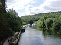 A tree-lined part of the Thames in the Goring Gap.
 -
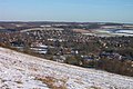 The river and gap seen from Lardon Chase on a snowy January day, with the Chilterns in the background


Notes and References
- ^ Cretaceous sea levels were 550 feet higher than today, at mongabay.com.
- ^ Gibbard, P.L. & Lewin, J., 2003 ("Gibbard & Lewin 2003"), The history of the major rivers of southern Britain during the Tertiary, Journal of the Geological Society, 160, pages 829-845. Tectonic map and Palaeocene sections. Online at www.qpg.geog.cam.ac.uk.
- ^ Sir A. STRAHAN, K.B.E., F.R.S. (1924). "THE GEOLOGY OF THE THAMES VALLEY NEAR GORING, as illustrated by the Model in the Museum of Practical Geology". Reports & Proceedings—Geologists Association. Mem. Geol. Surv. 63 (1): 43. Retrieved 17 January 2024.
{{cite journal}}: CS1 maint: multiple names: authors list (link) - ^ Westland Green Gravel Member, British Geological Survey Lexicon of Named Rock Units, at webapps.bgs.ac.uk.
- ^ a b c Gibbard, P.L. (1985) ("Gibbard 1985"), The Pleistocene history of the Middle Thames Valley, Cambridge University Press.
- ^ BGS Geology Viewer, British Geological Survey, at geologyviewer.bgs.ac.uk.
- ^ However, the Westland Green Gravel may have been laid down at a lower altitude relative to sea level at that time, because "... early Pleistocene uplift of western and north-western Britain caused a relative displacement of c.180m between the western London Basin and the Suffolk coast" - Gibbard & Lewin 2003, Neogene (Miocene and Pliocene) sections.
- ^ Lee, J.R., Rose J. and others, 2011 ("Lee and others 2011"), The Glacial History of the British Isles during the Early and Middle Pleistocene: Implications for the long-term development of the British Ice Sheet, pages 59-74 in Quaternary Glaciations - Extent and Chronology, a Closer Look. Developments in Quaternary Science, 15, (Amsterdam: Elsevier). On page 63, the "Westland Green terrace" is "tentatively assigned" to Marine Isotope Stages 62-54 (1.75Ma - 1.6Ma). See the chart at quaternary.stratigraphy.org
- ^ Lee and others 2011, page 63. There, the "Stoke Row terrace" is "tentatively assigned" to Marine Isotope Stage 68 - that is, around 1.8 million years ago.
- ^ It is also possible that, at an even earlier time during the Early Pleistocene, the Thames flowed further north-east, through where Nettlebed is now located. Deposits of "gravel with a sandy matrix", which may have been laid down by the Thames, have been found there, at an altitude of just over 200 metres. See Gibbard 1985, page 8. However, doubt has been cast upon the Thames origin of these deposits. See: Peter Worsley, 2016, A reconsideration of the origin of the early Pleistocene ‘Pebble Gravel Formation’ at Nettlebed, Oxfordshire, south central England, Proceedings of the Geologists’ Association, 127, 445–450; partly online at www.sciencedirect.com. See also: Geology at Nettlebed, Reading and District Natural History Society, December 2021.
- ^ The name "Westland Green Gravel" was first proposed in Hey, R.W., 1965, Highly quartzose pebble gravels in the London Basin, Proc. Geol. Ass., 76, 403-20. Westland Green is a location in Hertfordshire near Bishop's Stortford where an outcrop of this formation was identified by Hey.
- ^ Bridgland, D.R. (1994, 2012) ("Bridgland 1994"), Quaternary of the Thames, Geological Conservation Review Series, Springer Science & Business Media, ISBN 978-94-010-4303-8, ISBN 978-94-011-0705-1 (eBook) (originally published by Chapman and Hall). "...there is abundant evidence to show that the modern Thames is a mere shadow of its Pleistocene forebear. Not only did it once flow from the London Basin out across East Anglia to north Norfolk, but there are indications that its headwaters may once have drained a large part of the West Midlands and even North Wales" (from chapter 1).
- ^ Gibbard 1985, page 135; and Gibbard P.L., Turner C., West R.G., 2013, The Bytham river reconsidered, Quaternary International, 292, pages 15-32.
- ^ Bridgland 1994, chapter 1, "The diversion of the Thames".
- ^ Bridgland 1994, chapter 1, "Terrace Formation".
External links
 Media related to Goring Gap at Wikimedia Commons
51°31′23″N 01°08′30″W / 51.52306°N 1.14167°W
Category:Landforms of Berkshire Category:Landforms of Oxfordshire Category:Geology of Oxfordshire Category:Geology of Berkshire Category:Transport in Berkshire Category:Transport in Oxfordshire Category:Chiltern Hills Category:Geography of the River Thames Category:Landforms of England