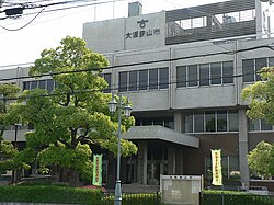
Ōsakasayama
Ōsakasayama
| |
|---|---|
 Ōsakasayama City Hall | |
 Location of Ōsakasayama in Osaka Prefecture | |
| Coordinates: 34°30′N 135°33′E / 34.500°N 135.550°E | |
| Country | Japan |
| Region | Kansai |
| Prefecture | Osaka |
| Government | |
| • Mayor | Tomoyoshi Yoshida (since April 2003) |
| Area | |
| • Total | 11.92 km2 (4.60 sq mi) |
| Population (January 31, 2022) | |
| • Total | 58,465 |
| • Density | 4,900/km2 (13,000/sq mi) |
| Time zone | UTC+09:00 (JST) |
| City hall address | 1-2384-1 Sayama, Sayama-shi, Osaka-fu 589-8501 |
| Website | Official website |
| Symbols | |
| Flower | Azalea |
| Tree | Cherry blossom |

Ōsakasayama (
Geography
[edit]Ōsakasayama is located in the southeastern part of Osaka Prefecture. Sayama pond, which is said to be the oldest dam-type reservoir in Japan, is located in the center of the city and is a symbol of the city.
Neighboring municipalities
[edit]Osaka Prefecture
Climate
[edit]Ōsakasayama has a Humid subtropical climate (Köppen Cfa) characterized by warm summers and cool winters with light to no snowfall. The average annual temperature in Ōsakasayama is 14.6 °C. The average annual rainfall is 1475 mm with September as the wettest month. The temperatures are highest on average in August, at around 26.6 °C, and lowest in January, at around 3.2 °C.[2]
Demographics
[edit]Per Japanese census data,[3] the population of Ōsakasayama has increased for


