
Cape Shionomisaki
Cape Shionomisaki
| |
|---|---|
 Cape Shionomisaki aerial photograph | |
 Cape Shionomisaki Cape Shionomisaki  Cape Shionomisaki Cape Shionomisaki (Japan) | |
| Coordinates: 33°26′15″N 135°45′16″E / 33.43750°N 135.75444°E | |
| Location | Kushimoto, Wakayama, Japan |
| Offshore water bodies | Pacific Ocean |
Cape Shionomisaki (
Geologically, the cape is a flat uplifted seafood plateau with an elevation of 60 to 80 meters consisting of two marine terraces, and a coastal cliff with a height of 40 meters. Originally an island, gravel from the estuary of nearby rivers is carried by coastal currents to form a sandbar, which now connects the island to land.
Cape Shionomisaki is the location of the Shionomisaki Lighthouse,[1] one of the “50 Lighthouses of Japan” by the Japan Lighthouse Association.[2]
Climate
[edit]| Climate data for Cape Shionomisaki, Kushimoto (elevation 68 m (223 ft), 1991−2020 normals, extremes 1913−present) | |||||||||||||
|---|---|---|---|---|---|---|---|---|---|---|---|---|---|
| Month | Jan | Feb | Mar | Apr | May | Jun | Jul | Aug | Sep | Oct | Nov | Dec | Year |
| Record high °C (°F) | 23.6 (74.5) |
23.4 (74.1) |
23.9 (75.0) |
26.2 (79.2) |
29.4 (84.9) |
30.8 (87.4) |
35.6 (96.1) |
36.1 (97.0) |
33.8 (92.8) |
29.7 (85.5) |
27.2 (81.0) |
23.3 (73.9) |
36.1 (97.0) |
| Mean daily maximum °C (°F) | 11.4 (52.5) |
12.4 (54.3) |
15.2 (59.4) |
18.8 (65.8) |
22.5 (72.5) |
24.7 (76.5) |
28.2 (82.8) |
29.8 (85.6) |
27.6 (81.7) |
23.2 (73.8) |
18.7 (65.7) |
13.8 (56.8) |
20.5 (68.9) |
| Daily mean °C (°F) | 8.3 (46.9) |
8.8 (47.8) |
11.6 (52.9) |
15.6 (60.1) |
19.3 (66.7) |
22.1 (71.8) |
25.7 (78.3) |
26.9 (80.4) |
24.6 (76.3) |
20.3 (68.5) |
15.5 (59.9) |
10.6 (51.1) |
17.5 (63.5) |
| Mean daily minimum °C (°F) | 5.2 (41.4) |
5.3 (41.5) |
8.2 (46.8) |
12.3 (54.1) |
16.6 (61.9) |
19.9 (67.8) |
23.8 (74.8) |
24.8 (76.6) |
22.1 (71.8) |
17.7 (63.9) |
12.4 (54.3) |
7.5 (45.5) |
14.6 (58.3) |
| Record low °C (°F) | −3.6 (25.5) |
−5.0 (23.0) |
−2.2 (28.0) |
1.5 (34.7) |
7.3 (45.1) |
12.5 (54.5) |
15.3 (59.5) |
18.1 (64.6) |
14.2 (57.6) |
7.7 (45.9) |
2.5 (36.5) |
−2.0 (28.4) |
−5.0 (23.0) |
| Average precipitation mm (inches) | 97.7 (3.85) |
118.1 (4.65) |
185.5 (7.30) |
212.3 (8.36) |
236.7 (9.32) |
364.7 (14.36) |
298.4 (11.75) |
260.3 (10.25) |
339.2 (13.35) |
286.6 (11.28) |
152.0 (5.98) |
102.9 (4.05) |
2,654.3 (104.50) |
| Average precipitation days (≥ 0.5 mm) | 7.1 | 8.3 | 11.8 | 11.4 | 11.9 | 15.8 | 12.9 | 12.4 | 13.2 | 12.0 | 9.3 | 7.0 | 133.1 |
| Average relative humidity (%) | 58 | 58 | 62 | 68 | 75 | 84 | 86 | 84 | 78 | 72 | 64 | 60 | 71 |
| Mean monthly sunshine hours | 192.5 | 187.9 | 198.6 | 201.9 | 193.2 | 132.4 | 193.2 | 234.8 | 176.8 | 169.8 | 177.5 | 194.0 | 2,255.9 |
| Source: Japan Meteorological Agency[3][4] | |||||||||||||
Gallery
[edit]-
 Shionomisaki Lighthouse
 -
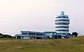 Shionomisaki Tower
 -
 Monument marking the southernmost point of Honshu
 -
 Nanki Kumano Geopark Center


References
[edit]- ^
串本 町 観光 協会 , ed. (June 2014). "潮岬 灯台 " (in Japanese). Archived from the original on 22 May 2015. Retrieved 14 August 2015.. - ^ Japan Lighthouse Association home page Archived 2018-04-05 at the Wayback Machine (in Japanese)
- ^ "
平年 値 ダウンロード". Japan Meteorological Agency. Archived from the original on July 26, 2021. Retrieved June 1, 2021. - ^
"
観測 史上 1〜10位 の値 (年間 を通 じての値 )". Japan Meteorological Agency. Retrieved June 1, 2021.