
Wakayama Prefecture
Wakayama Prefecture
| |
|---|---|
| Japanese transcription(s) | |
| • Japanese | |
| • Rōmaji | Wakayama-ken |
 Cherry blossoms bloom in the courtyard of Negoro-ji Temple in Iwade City, Wakayama Prefecture | |
 Flag  Symbol | |
| Anthem: Wakayama kenminka | |
 | |
| Country | Japan |
| Region | Kansai |
| Island | Honshū |
| Capital | Wakayama (city) |
| Subdivisions | Districts: 6, Municipalities: 30 |
| Government | |
| • Governor | Shūhei Kishimoto (since December 17, 2022) |
| Area | |
| • Total | 4,724.69 km2 (1,824.21 sq mi) |
| • Rank | 30th |
| Population (1 October 2017) | |
| • Total | 944,320 |
| • Rank | 39th |
| • Density | 199.87/km2 (517.7/sq mi) |
| • Dialects | Kishū |
| GDP | |
| • Total | JP¥ 3,745 billion US$ 34.4 billion (2019) |
| ISO 3166 code | JP-30 |
| Website | www.wakayama.lg.jp/ english/ |
| Symbols of Japan | |
| Bird | Japanese white-eye (Zosterops japonica) |
| Flower | Ume blossom (Prunus mume) |
| Tree | Ubame oak (Quercus phillyraeoides) |
Wakayama Prefecture (
Wakayama is the capital and largest city of Wakayama Prefecture, with other major cities including Tanabe, Hashimoto, and Kinokawa.[3]: 1025 Wakayama Prefecture is located on the southwestern coast of the Kii Peninsula on the Kii Channel, connecting the Pacific Ocean and Seto Inland Sea, across from Tokushima Prefecture on the island of Shikoku.
History[edit]
Present-day Wakayama is mostly the western part of the province of Kii.[4]
1953 flood disaster[edit]
On July 17–18, 1953, a torrential heavy rain occurred, followed by collapse of levees, river flooding and landslides in a wide area. Many bridges and houses were destroyed. According to an officially confirmed report by the Government of Japan, 1,015 people died, with 5,709 injured and 7,115 houses lost.[citation needed]
Geography[edit]

City Town Village
As of 31 March 2020, 13 percent of the total land area of the prefecture was designated as Natural Parks, namely the Setonaikai and Yoshino-Kumano National Parks; Kongō-Ikoma-Kisen and Kōya-Ryūjin Quasi-National Parks; and Enju Kaigan, Hatenashi Sanmyaku, Hikigawa, Jōgamori Hokodai, Kōyasanchō Ishimichi-Tamagawakyō, Kozagawa, Nishiarida, Oishi Kōgen, Ōtōsan, Ryūmonzan, Shiramisan-Wadagawakyō, and Shirasaki Kaigan Prefectural Natural Parks.[5]
Cities[edit]
Nine cities are in Wakayama Prefecture:
| Name | Area (km2) | Population | Map | |
|---|---|---|---|---|
| Rōmaji | Kanji | |||
| 36.91 | 27,963 | 
| ||
| 43.78 | 27,483 | 
| ||
| 130.31 | 62,941 | |||
| 38.5 | 53,280 | 
| ||
| 101.18 | 51,112 | 
| ||
| 228.24 | 61,850 | 
| ||
| 255.43 | 26,815 | 
| ||
| 1,026.91 | 70,410 | 
| ||
| 210.25 | 360,664 | 
| ||
Towns and villages[edit]
These are the towns and villages in each district:
| Name | Area (km2) | Population | District | Type | Map | |
|---|---|---|---|---|---|---|
| Rōmaji | Kanji | |||||
| 351.77 | 26,245 | Arida District | Town | 
| ||
| 46.42 | 7,666 | Hidaka District | Town | 
| ||
| 331.61 | 9,615 | Hidaka District | Town | 
| ||
| 65.35 | 7,059 | Arida District | Town | 
| ||
| 113.63 | 7,949 | Hidaka District | Town | 
| ||
| 57.49 | 15,047 | Nishimuro District | Town | 
| ||
| かつらぎ |
151.73 | 16,686 | Ito District | Town | 
| |
| 128.31 | 8,989 | Kaisō District | Town | 
| ||
| 48.21 | 432 | Higashimuro District | Village | 
| ||
| 137.08 | 3,279 | Ito District | Town | 
| ||
| 294.52 | 2,749 | Higashimuro District | Town | 
| ||
| 44.19 | 4,295 | Ito District | Town | 
| ||
| 135.78 | 16,243 | Higashimuro District | Town | |||
| 12.79 | 7,391 | Hidaka District | Town | 
| ||
| みなべ |
120.26 | 12,561 | Hidaka District | Town | 
| |
| 183.45 | 17,261 | Higashimuro District | Town | 
| ||
| 201.04 | 23,325 | Nishimuro District | Town | 
| ||
| すさみ |
174.71 | 4,011 | Nishimuro District | Town | 
| |
| 5.96 | 3,428 | Higashimuro District | Town | 
| ||
| 20.8 | 11,960 | Arida District | Town | 
| ||
| 30.74 | 5,738 | Hidaka District | Town | 
| ||
Mergers[edit]
Demographics[edit]

Since 1996, population of Wakayama Prefecture has kept declining, and since 2010, it has been the only prefecture in Kansai region with population below 1,000,000. In 2017, Wakayama is ranked 40th by population in Japan with a population of 944,320. In the 2020 census, close to 32% of the population was over 65 years of age - the highest percentage in Japan and one of the highest for national subdivisions worldwide.[6]
Politics[edit]
The current governor Shūhei Kishimoto was elected on 27 November 2022.[7]
Prefectural assembly[edit]
| Political party | Number of seats |
|---|---|
| Liberal Democratic Party | 28 |
| Reform Club ( |
5 |
| Komeito | 3 |
| Nippon Ishin no Kai | 3 |
| Japanese Communist Party | 1 |
| Independent society | 1 |
| Independent | 1 |
List of governors of Wakayama[edit]
State-appointed governors:
|
|
Publicly-elected governors:
|
|
Culture[edit]
Mount Kōya (
The Kumano Shrines are on the southern tip of the prefecture. Tomogashima (a cluster of four islands) is part of the prefecture.
Agriculture[edit]
Orange[edit]
Wakayama Prefecture ranks first in the production of oranges in Japan. Wakayama has its own brand of oranges, which is produced in Arida District and called 'Arida-Orange'. Arida District, where oranges have been produced for more than 400 years,[10] yields about half of the orange crops in Wakayama today.[11] Furthermore, the yield of Arida-Oranges accounts for about 10 percent of Japanese domestic production of oranges.[12]
Japanese apricot (Ume)[edit]
According to the survey by the Ministry of Agriculture, Forestry and Fisheries of Japan, Wakayama stands first in the production of Japanese apricots (
Sister relationships[edit]
Wakayama Prefecture has friendship and sister relationships with six places outside Japan:[14]
- Shandong, People's Republic of China
- Pyrénées-Orientales, France
- Florida, United States
- Sinaloa, Mexico
- Galicia, Spain
- Sichuan, People's Republic of China
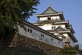
Tourism[edit]
Wakayama Prefecture has hot springs such as Shirahama, Kawayu, and Yunomine Onsen.
-
 Saikazaki, Wakanoura
 -
-
 The Museum of Modern Art, Wakayama
 -
 Konpon Daido
(Mount Kōya) -

-

-

-
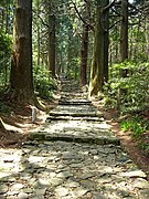 Daimonzaka
(Kumano Kodō)


Transportation[edit]
Rail[edit]
- JR West
- JR Central
- Nankai
- Kishu Railway
- Wakayama Electric Railway
Road[edit]
Expressway[edit]
- Hanwa Expressway
- Keinawa Expressway
- Yuasa Gobo Road
- Nachi Katsuura Road
National Highway[edit]
- Route 24
- Route 26
- Route 42
- Route 168 (Shingu-Gojo-Ikoma-Hirakata)
- Route 169 (Shingu-Kumano-Kawakami-Yoshino-Asuka-Kashihara-Nara)
- Route 311 (Kamitonda-Tanabe-Shingu-kumano-Owase)
- Route 370 (Kainan-Hashimoto-Gojo-Uda-Nara)
- Route 371 (Kawachinagano-Hashimoto-Koya-Kushimoto)
- Route 424
Ferry[edit]
- Wakayama-Tokushima
Airport[edit]
Education[edit]
Universities[edit]
Notes[edit]
- ^ "2020
年度 国民 経済 計算 (2015年 基準 ・2008SNA) :経済 社会 総合 研究所 -内閣 府 ".内閣 府 ホームページ (in Japanese). Retrieved 2023-05-18. - ^ Nussbaum, Louis-Frédéric. (2005). "Wakayama prefecture" in Japan Encyclopedia, p. 1026, p. 1026, at Google Books; "Kansai" in p. 477, p. 477, at Google Books.
- ^ Nussbaum, "Wakayama" in p. 1025, p. 1025, at Google Books.
- ^ Nussbaum, "Provinces and prefectures" in p. 780, p. 780, at Google Books.
- ^
自然 公園 都道府県 別 面積 総括 [General overview of area figures for Natural Parks by prefecture] (PDF) (in Japanese). Ministry of the Environment. 31 March 2020. Retrieved 23 January 2020. - ^ 2020 population census of Japan. https://www.stat.go.jp/english/data/kokusei/2020/summary.html
- ^ "Kishimoto Wins 1st Term as Governor of Japan's Wakayama Pref".
時事通信 ニュース. 28 November 2022. Retrieved 26 July 2023. - ^ "
和歌山 県議会 会派 名簿 " [List of factions in the Wakayama Prefectural Assembly] (PDF). Wakayama Prefecture (in Japanese). 17 May 2023. Retrieved 26 July 2023. - ^ UNESCO.org
- ^
今月 の旬 Wakayama Prefecture website, accessed May 31, 2017 - ^
農林 水産 特産 品 Wakayama Prefecture website, accessed May 31, 2017 - ^
有田 みかんについて JA Arida website, accessed May 31, 2017 - ^
作況 調査 (果樹 ):農林水産省 The Ministry of Agriculture, Forestry and Fisheries website, accessed June 1, 2017 - ^
友好 ・姉妹 提携 Archived 2011-06-11 at the Wayback Machine Wakayama Prefecture website, retrieved May 16, 2008
References[edit]
- Nussbaum, Louis-Frédéric and Käthe Roth. (2005). Japan encyclopedia. Cambridge: Harvard University Press. ISBN 978-0-674-01753-5; OCLC 58053128
External links[edit]
34°3′N 135°21′E / 34.050°N 135.350°E
| Core city | | |
|---|---|---|
| Cities | ||
| Districts | ||

| International | |
|---|---|
| National | |
| Geographic | |
| Academics | |
| Other | |