
Mozu Tombs
| Mozu Tombs | |
|---|---|
| Sakai, Osaka Prefecture, Japan | |
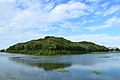
 The Mozu Tombs Cluster Area Created based on aerial photographs from the Japan Geospatial Information Authority of the Ministry of Land, Infrastructure, Transport and Tourism's map and aerial photo browsing service. | |
 Mozu Tombs | |
| Coordinates | 34°33′50″N 135°29′13″E / 34.564°N 135.487°E |
| Site information | |
| Owner | Imperial Household Agency |
| Condition | Intact |
| Site history | |
| Built | 3rd to 6th century |
| Criteria | Cultural: iii, iv |
| Reference | 1593 |
| Inscription | 2019 (43rd Session) |
| Area | 166.6 ha |
| Buffer zone | 890 ha |


The Mozu Tombs (
The Daisenryo Kofun (
Location[edit]
The Mozu Kofun Cluster is located in the city of Sakai which is within Osaka Prefecture. The tumuli are built on a plateau overlooking Osaka Bay near the ancient coastline and are distributed in a range of about four kilometers from east-to-west and north-to-south.The Furuichi Kofun Cluster is located in nearby Habikino and Fujiidera cities.[5]
History[edit]
In the Japanese archipelago, more than 20,000 tumuli (kofun), which are mounds of earth and stones erected over graves of the ruling class, were built between the later part of the 3rd century and the 6th century.[6] It was the peak period of building such mounds.[5] They represent a cultural tradition which is an expression of "forms, and design of the kofun" of the sociopolitical hierarchical order and the link that was prevalent during that period between regions. This period is termed as the Kofun Period.[6] The most prominent imperial mausolea in this cluster of tumuli are those of Emperor Nintoku and Emperor Richū.[7]
There are 44 burial mounds in the Mozu cluster, including those that are partially destroyed.[8] Of these, 19 have been designated as national historic sites,[9][10] and separately, the Imperial Household Agency has ruled three to be Imperial mausoleums, two to be "Tomb Reference Sites", and 18 to be "baichō", or ancillary mausoleums connected with an Imperial mausoleum.[11] There used to be more than 100 burial mounds, but due to the rapid development of residential land after World War II, more than half of the burial mounds were destroyed.[8]
In 2010, the Japanese government proposed that the Daisen Kofun and the entire cluster of Mozu Tombs and Furuichi Tombs be designated as a UNESCO World Heritage Site.[12] 9 years later on 6 July 2019, the site was approved and inscribed as a UNESCO World Heritage Site under Criteria: (iii) and (iv) as the Mozu-Furuichi Kofun Group: Mounded Tombs of Ancient Japan.[13]
Features[edit]
The kofun are found in many shapes and dimensions in varying patterns. Some are of simple circular or square shape (empun and hōfun). The larger ones are keyhole-shaped (zempō kōenfun); they represent the highest class of kofun and were built in great detail.[6] The three prominent aspects of these kofun are their massive size and being surrounded by several moats and many secondary kofun.[5]
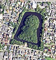
In the Osaka Plain and Nara Basin, which were the cultural centre of the Kofun Period, the rounded keyhole-shaped tombs were built extending to very large lengths, out of which the Mozu-Furuichi Kofun Clusters are the most prominent. These are in two kofun groups which are dated to the later part of 4th and early part of 6th centuries. These kofun are of the largest dimensions in the country. The Nintoku-tennō-ryō Kofun, is one grave mound which is a 486 metres (1,594 ft) long tumulus enclosed by a moat and a fortification which is 840 metres (2,760 ft) in length; this is said to be the largest such mound in the world. This cluster also has the Richū-tennō-ryō Kofun, made of a tumulus of 360 metres (1,180 ft) length and said to be the third largest in the country.[6]
Another group of mounds, located about 10 kilometres (6.2 mi) away from the Mozu cluster is known as the Furuichi cluster. It has the Ōjin-tennō-ryō Kofun of 425 metres (1,394 ft) length which is said to be the second largest in the country. This group also has 11 more huge massive rounded "keyhole-shaped kofun" with mound length of 200 metres (660 ft) or more.[6]
A feature of these funerary mounds is that they contain – along with the buried people – grave goods made of iron, weapons worn by individuals including arrowheads, swords, hoe and spade tips, and many other similar items. Also found in the mounds are antiquities made of gilded bronze such as horse tacks and sash buckles.[5]
The Daisen Kofun mound is approximately 500 metres (1,600 ft) long and 300 metres (980 ft) across at its widest point, while the entire tomb area is 840 metres (2,760 ft) long.[14] Enclosed by three moats, the mound rises approximately 35m above the surrounding terrain. The highest point is 47 metres (154 ft), making it visible to the seafarers in nearby Osaka Bay.[15] The inner moat is the widest of the moats at approximately 60 metres (200 ft). The mound is approximately 100,000 square metres (1,100,000 sq ft) in area, and the entire tomb is 460,000 square metres (5,000,000 sq ft).
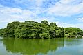
Today, the tomb is off-limits and protected by the Imperial Household Agency in the centre of Sakai City. The moats have been maintained and provide a sanctuary for fish and waterbirds. The mound itself is completely overgrown by vegetation. A viewing platform from the second (middle) moat is accessible at the south side of the site. The viewing platform is 500m away from Mozu Station on the Hanwa Line and is directly across the street from the Sakai City Museum.[16] This museum provides visitors with information about the kofun and its history.
Gallery[edit]
-
 Daisenryo Kofun, 2.8 km in circumference and the largest kofun in Japan, is thought to be the Tomb of Emperor Nintoku.
 -
 Kamiishizu Misanzai Kofun
 -
 Haze Nisanzai Kofun
 -
 Mozu Gobyo-yama Kofun
 -
 Tadeiyama Kofun
 -
 Itasuke Kofun


| Name | Name | Location | Type | Length | National Historic Site | Imperial Household Agency | World Heritage Site & Comments |
|---|---|---|---|---|---|---|---|
| Daisenryō Kofun | Sakai-ku, Sakai | keyhole | 525 m | Emperor Nintoku | WHS | ||
| Kamiishizumisanzai Kofun | Nishi-ku, Sakai | keyhole | 365 m | Emperor Richū | WHS | ||
| Hazenisanzai Kofun | Nishi-ku, Sakai | keyhole | 290 m | NHS | East Mozu Reference Site | WHS | |
| Kobyōyama Kofun | Kita-ku,Sakai | keyhole | 203 m | NHS | Mozu Reference Site | WHS | |
| Chin'ooka Kofun | Sakai-ku,Sakai | keyhole | 155 m | NHS | |||
| Tadeiyama Kofun | Sakai-ku,Sakai | keyhole | 148 m | Emperor Hanzei | WHS | ||
| Itasuke Kofun | いたすけ |
Kita-ku, Sakai | keyhole | 146 m | NHS | WHS | |
| Nagatsuka Kofun | Sakai-ku,Sakai | keyhole | 106 m | NHS | WHS | ||
| Nagayama Kofun | Sakai-ku, Sakai | keyhole | 100 m | Sakai city HS | Emperor Nintoku baichō | WHS | |
| Maruhoyama Kofun | Sakai-ku,Sakai | Scallop | 87 m | NHS | Emperor Nintoku baichō | WHS | |
| Gobyō-Omotezuka Kofun | Kita-ku, Sakai | keyhole | 85 m | NHS | |||
| Zenizuka Kofun | Sakai-ku, Sakai | Scallop | 72 m | NHS | WHS | ||
| Jōnoyama Kofun | Kita-ku, Sakai | Scallop | 69 m | ||||
| Daianjiyama Kofun | Sakai-ku, Sakai | circular | 62 m | Emperor Nintoku baichō | WHS | ||
| Tatsusayama Kofun | Sakai-ku, Sakai | Scallop | 61 m | Sakai city HS) | Emperor Nintoku baichō | WHS | |
| Guwashobō Kofun | グワショウ |
Sakai-ku, Sakai | circular | 61 m | NHS | ||
| Monjuzuka Kofun | Nishi-ku,Sakai | keyhole | 59 m | NHS | |||
| Osamezuka Kofun | Sakai-ku, Sakai | Scallop | 58 m | NHS | WHS | ||
| Hatazuka Kofun | Kita-ku, Sakai | Scallop | 58 m | NHS | WHS | ||
| Chayama Kofun | Sakai-ku, Sakai | circular | 56 m | Emperor Nintoku baichō | WHS | ||
| Magodaiyūyama Kofun | Sakai-ku,Sakai | Scallop | 56 m | Emperor Nintoku baichō | WHS | ||
| Kabutozuka Kofun | かぶと |
Nishi-ku, Sakai | Scallop | 50 m | |||
| Hinotani Kofun | Sakai-ku, Sakai | circular | 47 m | Emperor Nintoku baichō | |||
| Terayama Minamiyama Kofun | Nishi0ku, Sakai | square | 45 m | NHS | WHS | ||
| Genemonyama Kofun | Sakai-ku, Sakai | circular | 34 m | Emperor Nintoku baichō | WHS | ||
| Chinjuyama Kofun | Kita-ku, Sakai | circular | 34 m | ||||
| Komoyamazuka Kofun | Sakai-ku, Sakai | Scallop | 33 m | Emperor Nintoku baichō | WHS | ||
| Shichikannon Kofun | Sakai-ku, Sakai | circular | 33 m | NHS | WHS | ||
| Tsukamawari Kofun | Sakai-ku, Sakai | circular | 32 m | NHS | WHS | ||
| Kitsuneyama Kofun | Sakai-ku, Sakai | circular | 30 m | Emperor Nintoku baichō | |||
| Zan'emonyama Kofun | Kita-ku, Sakai | square | 28 m | NHS | WHS | ||
| Kagamizuka Kofun | Kita-ku, Sakai | circular | 26 m | NHS | |||
| Dōgameyama Kofun | Sakai-ku, Sakai | square | 26 m | Emperor Nintoku baichō | WHS | ||
| Donchayama Kofun | ドンチャ |
Kita-ku, Sakai | circular | 26 m | NHS | ||
| Mozuyama Kofun | Kita-ku, Sakai | keyhole | 25 m+ | ||||
| Nishisakenomi Kofun | Sakai-ku, Sakai | circular | 25 m | Emperor Richū baichō | |||
| Hinokizuka Kofun | Sakai-ku, Sakai | keyhole | 25 m | Emperor Richū baichō | |||
| Suzuyama Kofun | Sakai-ku, Sakai | square | 22 m | Emperor Hanzei baichō | |||
| Higashisakenomi Kofun | Sakai-ku,Sakai | circular | 21 m | Emperor Richū baichō | |||
| Kyōdō Kofun | Sakai-ku, Sakai | circular | 20 m | Emperor Richū baichō | |||
| Shorakujiyama Kofun | Kita-ku, Sakai | circular | 16 m | NHS | |||
| Tennō Kofun | Sakai-ku, Sakai | square | 11 m | Emperor Hanzei baichō | |||
| Hōzuyama Kofun | Kita-ku, Sakai | circular | 10 m | Emperor Nintoku baichō | |||
| Higashi Ueno Shibamachi No.1 Kofun | Sakai-ku, Sakai | circular |
See also[edit]
- List of Historic Sites of Japan (Osaka)
- List of National Treasures of Japan (archaeological materials)
- Buried Cultural Properties
- World Heritage Sites in Japan
References[edit]
- ^ "Enjoying Sakai – Kofun Tombs (Tumuli)". Sakai City. Archived from the original on 22 July 2011. Retrieved 8 May 2011.
- ^ "Kofun Database". Sakai City. Archived from the original on 22 July 2011. Retrieved 8 May 2011.
- ^ "Graves | Japanology Plus – TV – NHK World – English". www3.nhk.or.jp. Archived from the original on 2018-06-26.
- ^ "
堺 市 ・仁徳 陵 古墳 ". kiis.or.jp. Retrieved 23 February 2017. - ^ a b c d "Characteristics of Mozu-Furuichi Kofungun". World Cultural Heritage for Osaka. Retrieved 22 November 2015.
- ^ a b c d e "Mozu-Furuichi Kofungun, Ancient Tumulus Clusters". UNESCO. Retrieved 22 November 2015.
- ^ Fawcett 1990, p. 111.
- ^ a b
古墳 データベース –堺 市 ウェブサイト(2017年 6月 11日 閲覧 ) - ^ "
百舌鳥 古墳 群 " [Mozu kofungun] (in Japanese). Agency for Cultural Affairs. Retrieved August 20, 2020. - ^ Isomura, Yukio; Sakai, Hideya (2012). (
国 指定 史跡 事典 ) National Historic Site Encyclopedia.学生 社 . ISBN 978-4311750403.(in Japanese) - ^ Of the burial mounds, the Itasuke burial mound was designated as a national historic site in 1956, and 19 units have been designated by 2019, including those that were additionally designated after that (Notice of the Ministry of Education, Culture, Sports, Science and Technology on October 15, 2018). No. 193, February 26, 2019, Ministry of Education, Culture, Sports, Science and Technology Notification No. 25).
- ^ Centre, UNESCO World Heritage. "Mozu-Furuichi Kofungun, Ancient Tumulus Clusters – UNESCO World Heritage Centre". unesco.org. Retrieved 23 February 2017.
- ^ "Seven cultural sites inscribed on UNESCO's World Heritage List". UNESCO. 6 July 2019.
- ^ city, Sakai. "
仁徳 天皇陵 古墳 (大山 古墳 )堺 市 ". sakai.lg.jp. Retrieved 23 February 2017. - ^ "Mozu Daisenryo Kofun – Japan Airlines". jal.japantravel.com. Retrieved 2022-03-20.
- ^ city, Sakai. "
堺 市 博物館 堺 市 ". sakai.lg.jp. Retrieved 23 February 2017. - ^ Mozu / Furuichi Kofungun List (Mozu)(Mozu-Furuichi Kofungun World Cultural Heritage Registration Promotion Headquarters Meeting)
Bibliography[edit]
- Fawcett, Clare P. (1990). A study of the socio-political context of Japanese archaeology. McGill University, Montréal.
External links[edit]
- (in English) Entry on UNESCO World Heritage tentative list
- (in Japanese) Mozu Kofun database
- (in Japanese) Decorated Kofun Database

| International | |
|---|---|
| National | |
| Elements | 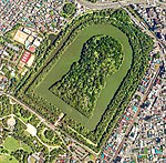 | |
|---|---|---|
| Types |
| |
| Groups | ||
| Individual | ||