Shitada, Niigata
Shitada
| |
|---|---|
Former municipality | |
 Yagigahana | |
| Country | Japan |
| Region | Hokuriku |
| Prefecture | Niigata Prefecture |
| District | Minamikanbara District |
| Merged | May 1, 2005 (now part of Sanjō) |
| Area | |
| • Total | 311.00 km2 (120.08 sq mi) |
| Population (2003) | |
| • Total | 11,118 |
| Time zone | UTC+09:00 (JST) |

Shitada (
As of 2003, the village had an estimated population of 11,118 and a density of 35.75 persons per km2. The total area was 311.00 km2.
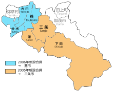
On May 1, 2005, Shitada, along with the town of Sakae (also from Minamikanbara District), was merged into the expanded city of Sanjō.[1][2]
Transportation[edit]
Railway[edit]
JNR Yahiko Line had been operated in the village until 1984.
Highway[edit]
Local attractions[edit]
-
Echigo-Nagano Onsen Rankeiso
References[edit]
- ^
住民 基本 台帳 人口 移動 報告 年報 (in Japanese).総務庁 統計 局 . 2005. p. 139.Sanjo-shi, Sakae-machi and Shitada-mura were incorporated into a newly established Sanjo-shi as of May 1, 2005.
- ^
荒川 区 . "新潟 県 三条 市 ".荒川 区 公式 サイト (in Japanese). Retrieved 2024-02-04.三条 市 は、新潟 県 のほぼ中央 に位置 し、平成 17年 5月 1日 に三条 市 ・栄 町 ・下田 村 の3市町村 が合併 し誕生 したまちです。


