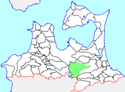
Towadako, Aomori
Towadako
| |
|---|---|
Former municipality | |
 Location of Towadako in Aomori Prefecture | |
| Coordinates: 40°35′11.3″N 141°06′32.4″E / 40.586472°N 141.109000°E | |
| Country | Japan |
| Region | Tōhoku |
| Prefecture | Aomori Prefecture |
| District | Kamikita |
| Merged | March 1, 2005 (now part of Towada) |
| Area | |
| • Total | 372.2 km2 (143.7 sq mi) |
| Population (January 1, 2005) | |
| • Total | 9,834 |
| • Density | 26.42/km2 (68.4/sq mi) |
| Time zone | UTC+09:00 (JST) |
| Website | City of Towada |
| Symbols | |
| Bird | Mandarin duck |
| Flower | Shakunage |
| Tree | Japanese rowan |
Towadako (
Located in south-central Aomori Prefecture, and encompassing the Aomori shoreline of Lake Towada, the town of Towadako had an economy based on tourism, forestry and agriculture.
At the time of its merger, the town had an estimated population of 9,834 and a density of 26.42 persons per km2. The total area was 372.2 km2.
Towadako was served by Japan National Route 102 highway, but had no railway service.
History[edit]
Hōosawa Village was founded in 1889 from the merger of the hamlets of Hōryō, Oirase, and Sawada. It changed its name to Towada Village in 1931 and was elevated to town status in 1955. In April 1975, it changed its name to Towadako Town. On January 1, 2005, Towadako was merged into the neighboring city of Towada,[1] and thus it no longer exists as an independent municipality.
References[edit]
- ^ "
総務 省 |令 和 2年版 地方 財政 白書 |資料 編 〔附属 資料 〕昭和 60年度 以降 の市町村 合併 の実績 " [Record of Municipal Mergers Since Showa 60].総務 省 (in Japanese). Retrieved 2024-02-28.
External links[edit]
- Towada city official website (in Japanese)


