
Wanzhou, Chongqing
Wanzhou
| |
|---|---|
 | |
 | |
 Wanzhou District in Chongqing | |
| Coordinates: 30°48′27″N 108°24′31″E / 30.8076°N 108.4086°E | |
| Country | People's Republic of China |
| Municipality | Chongqing |
| Area | |
| • District | 3,457 km2 (1,335 sq mi) |
| • Urban | 80 km2 (30 sq mi) |
| Population (2013) | |
| • District | 1,753,500 |
| • Density | 510/km2 (1,300/sq mi) |
| • Urban (2018)[1] | 700,000 |
| Time zone | UTC+8 (China Standard) |
| GDP | 2013 |
| - Total | CNY 70.23 billion (US$ 11.46 billion) |
| - Per capita | CNY 43,197 (US$ 7,047) |
| Licence plate prefix | 渝F |
| Website | wz |
Wanzhou District (simplified Chinese:
The characters for "Wanzhou" mean "myriad-prefecture"; which is derived from the phrase "the place where myriad rivers converge and myriad traders gather" (
History
[edit]
The district was part of Wanxian Prefecture (
It was part of Quren County of Ba Commandery (
In 619 (Tang dynasty), Nanpu Commandery (
In the 19th century, it was known in English as Wanhsien and Wan County. In 1935, it became Wanxian Prefecture (
The entire Wanxian City was merged into Chongqing on 20 December 1997. The merge necessitated the abolishment of Wanxian City and creation of Wanxian District and Wanxian Migration Development Area (
On 22 May 1998, the State Council approved that the two areas named Wanxian were both renamed to Wanzhou. The migration development area later dissolved and its counties were directly controlled by Chongqing. On 19 July 2000, the district's administrative committees were changed to migration development areas.
Sports
[edit]The 26,000-capacity Wanzhou Pailou Sports Stadium is located in Wanzhou. It is used mostly for association football and also sometimes for athletics. One stand is covered with a roof.
Geography and climate
[edit]Wanzhou spans 30°24′−31°14′ N latitude and 107°55′−108°53′ E longitude, and is situated at the eastern edge of the Sichuan Basin. It reaches a maximal north–south extent of 67.25 km (41.79 mi) and east–west width of 97.25 km (60.43 mi), covering an area of 3,214 km2 (1,241 sq mi). Elevations range from 106 m (348 ft) in the town of Tailong (
- Yunyang County – east
- Shizhu County – south
- Lichuan, Hubei – south
- Zhong County – west
- Liangping County – west
- Kaijiang County, Sichuan – north
- Kai County – north
Similar to the city proper of Chongqing, Wanzhou has a monsoon-humid subtropical climate (Köppen Cwa) with short, mild winters, and very hot, humid summers, and is in fact on average 0.5 °C (0.9 °F) warmer during the day. The monthly 24-hour average temperature ranges from 7.0 °C (44.6 °F) in January to 28.3 °C (82.9 °F) in August, while the annual mean is 17.95 °C (64.3 °F).
| Climate data for Wanzhou, elevation 187 m (614 ft), (1991–2020 normals, extremes 1981–2010) | |||||||||||||
|---|---|---|---|---|---|---|---|---|---|---|---|---|---|
| Month | Jan | Feb | Mar | Apr | May | Jun | Jul | Aug | Sep | Oct | Nov | Dec | Year |
| Record high °C (°F) | 19.1 (66.4) |
28.0 (82.4) |
33.3 (91.9) |
36.8 (98.2) |
39.5 (103.1) |
40.2 (104.4) |
41.5 (106.7) |
42.3 (108.1) |
42.0 (107.6) |
35.8 (96.4) |
29.1 (84.4) |
19.6 (67.3) |
42.3 (108.1) |
| Mean daily maximum °C (°F) | 11.0 (51.8) |
13.8 (56.8) |
18.9 (66.0) |
24.3 (75.7) |
27.8 (82.0) |
30.7 (87.3) |
34.4 (93.9) |
34.8 (94.6) |
29.7 (85.5) |
23.4 (74.1) |
18.2 (64.8) |
12.3 (54.1) |
23.3 (73.9) |
| Daily mean °C (°F) | 7.6 (45.7) |
9.6 (49.3) |
13.8 (56.8) |
18.9 (66.0) |
22.7 (72.9) |
25.8 (78.4) |
28.8 (83.8) |
28.9 (84.0) |
24.6 (76.3) |
19.1 (66.4) |
14.3 (57.7) |
9.2 (48.6) |
18.6 (65.5) |
| Mean daily minimum °C (°F) | 5.3 (41.5) |
6.8 (44.2) |
10.3 (50.5) |
15.1 (59.2) |
19.1 (66.4) |
22.4 (72.3) |
24.9 (76.8) |
24.7 (76.5) |
21.3 (70.3) |
16.6 (61.9) |
11.9 (53.4) |
7.1 (44.8) |
15.5 (59.8) |
| Record low °C (°F) | −2.2 (28.0) |
−1.3 (29.7) |
−0.1 (31.8) |
6.5 (43.7) |
11.2 (52.2) |
15.4 (59.7) |
17.6 (63.7) |
18.1 (64.6) |
14.3 (57.7) |
5.3 (41.5) |
2.9 (37.2) |
−2.1 (28.2) |
−2.2 (28.0) |
| Average precipitation mm (inches) | 16.2 (0.64) |
21.7 (0.85) |
50.2 (1.98) |
96.8 (3.81) |
172.0 (6.77) |
184.5 (7.26) |
180.2 (7.09) |
146.0 (5.75) |
141.2 (5.56) |
102.7 (4.04) |
53.7 (2.11) |
17.9 (0.70) |
1,183.1 (46.56) |
| Average precipitation days (≥ 0.1 mm) | 7.9 | 7.5 | 10.5 | 13.2 | 15.5 | 14.5 | 11.9 | 10.5 | 11.8 | 13.5 | 9.8 | 7.7 | 134.3 |
| Average snowy days | 0.3 | 0.1 | 0 | 0 | 0 | 0 | 0 | 0 | 0 | 0 | 0 | 0.1 | 0.5 |
| Average relative humidity (%) | 81 | 78 | 75 | 77 | 78 | 80 | 75 | 72 | 77 | 83 | 83 | 83 | 79 |
| Mean monthly sunshine hours | 27.1 | 38.6 | 84.9 | 118.0 | 116.4 | 118.9 | 186.7 | 198.8 | 123.8 | 74.6 | 53.1 | 27.2 | 1,168.1 |
| Percent possible sunshine | 8 | 12 | 23 | 30 | 27 | 28 | 44 | 49 | 34 | 21 | 17 | 9 | 25 |
| Source 1: China Meteorological Administration[3][4] | |||||||||||||
| Source 2: Weather China[5] | |||||||||||||
| Climate data for Wanzhou (Tiancheng District), elevation 257 m (843 ft), (1991–2020 normals) | |||||||||||||
|---|---|---|---|---|---|---|---|---|---|---|---|---|---|
| Month | Jan | Feb | Mar | Apr | May | Jun | Jul | Aug | Sep | Oct | Nov | Dec | Year |
| Mean daily maximum °C (°F) | 10.5 (50.9) |
13.3 (55.9) |
18.4 (65.1) |
23.9 (75.0) |
27.4 (81.3) |
30.2 (86.4) |
34.0 (93.2) |
34.3 (93.7) |
29.2 (84.6) |
22.8 (73.0) |
17.7 (63.9) |
11.7 (53.1) |
22.8 (73.0) |
| Daily mean °C (°F) | 7.0 (44.6) |
9.1 (48.4) |
13.2 (55.8) |
18.3 (64.9) |
22.1 (71.8) |
25.1 (77.2) |
28.1 (82.6) |
28.1 (82.6) |
23.9 (75.0) |
18.5 (65.3) |
13.7 (56.7) |
8.6 (47.5) |
18.0 (64.4) |
| Mean daily minimum °C (°F) | 4.7 (40.5) |
6.3 (43.3) |
9.6 (49.3) |
14.4 (57.9) |
18.4 (65.1) |
21.6 (70.9) |
24.2 (75.6) |
23.8 (74.8) |
20.5 (68.9) |
15.8 (60.4) |
11.2 (52.2) |
6.4 (43.5) |
14.7 (58.5) |
| Average precipitation mm (inches) | 17.9 (0.70) |
22.4 (0.88) |
53.6 (2.11) |
102.6 (4.04) |
180.7 (7.11) |
195.9 (7.71) |
186.7 (7.35) |
149.1 (5.87) |
148.9 (5.86) |
110.3 (4.34) |
58.6 (2.31) |
18.7 (0.74) |
1,245.4 (49.02) |
| Average precipitation days (≥ 0.1 mm) | 8.5 | 7.8 | 10.8 | 14.1 | 15.4 | 14.8 | 12.7 | 11.1 | 11.9 | 14.1 | 10.6 | 8.6 | 140.4 |
| Average snowy days | 0.5 | 0.1 | 0 | 0 | 0 | 0 | 0 | 0 | 0 | 0 | 0 | 0.1 | 0.7 |
| Average relative humidity (%) | 82 | 79 | 77 | 79 | 80 | 82 | 79 | 75 | 80 | 85 | 85 | 85 | 81 |
| Mean monthly sunshine hours | 28.9 | 40.4 | 84.9 | 115.0 | 111.4 | 110.3 | 177.1 | 193.8 | 119.0 | 70.8 | 55.2 | 28.6 | 1,135.4 |
| Percent possible sunshine | 9 | 13 | 23 | 30 | 26 | 26 | 41 | 48 | 32 | 20 | 18 | 9 | 25 |
| Source: China Meteorological Administration[3][6] | |||||||||||||
Subdivisions
[edit]The 4 primary subdivisions were 3 migration development areas (Longbao, Tiancheng, Wuqiao) and Jiangnan New District (
| Name | Chinese (S) | Hanyu Pinyin | Population (2010)[7] | Area (km2) |
|---|---|---|---|---|
| Gaosuntang Subdistrict | Gāosǔntáng Jiēdào | 103,982 | 3 | |
| Taibai Subdistrict | Tàibái Jiēdào | 108,387 | 13.1 | |
| Pailou Subdistrict | Páilóu Jiēdào | 104,351 | 9.8 | |
| Shuanghekou Subdistrict | Shuānghékǒu Jiēdào | 33,715 | 23 | |
| Longdu Subdistrict | 龙都 |
Lóngdōu Jiēdào | 36,134 | 24 |
| Zhoujiaba Subdistrict | Zhōujiābà Jiēdào | 88,494 | 12 | |
| Shahe Subdistrict | Shāhé Jiēdào | 24,915 | 11.2 | |
| Zhonggulou Subdistrict | 钟鼓 |
Zhōnggǔlóu Jiēdào | 85,873 | 38.7 |
| Bai'anba Subdistrict | Bǎi'ānbà Jiēdào | 91,947 | 15.8 | |
| Wuqiao Subdistrict | Wǔqiáo Jiēdào | 20,672 | 25.7 | |
| Chenjiaba Subdistrict | 陈家坝街 |
Chénjiābà Jiēdào | 24,745 | 34.75 |
| Xiaozhou town | Xiǎozhōu Zhèn | 9,136 | 49 | |
| Dazhou town | Dàzhōu Zhèn | 12,184 | 64 | |
| Xinxiang town | Xīnxiāng Zhèn | 6,683 | 140.2 | |
| Sunjia town | 孙家镇 | Sūnjiā Zhèn | 9,737 | 46.6 |
| Gaofeng town | Gāofēng Zhèn | 19,550 | 46.2 | |
| Longsha town | 龙沙镇 | Lóngshā Zhèn | 28,127 | 25 |
| Xiangshui town | 响水镇 | Xiǎngshuǐ Zhèn | 16,889 | 59.5 |
| Wuling town | Wǔlíng Zhèn | 24,632 | 34.4 | |
| Rangdu town | 瀼渡镇 | Ràngdù Zhèn[8] | 11,613 | 30.7 |
| Ganning town | Gānníng Zhèn | 30,873 | 104.8 | |
| Tiancheng town | Tiānchéng Zhèn | 41,762 | 52.4 | |
| Xiongjia town | Xióngjiā Zhèn | 33,176 | 82.5 | |
| Gaoliang town | Gāoliáng Zhèn | 49,357 | 37.7 | |
| Lihe town | Lǐhé Zhèn | 23,264 | 38.7 | |
| Fenshui town | Fēnshuǐ Zhèn | 60,308 | 220.96 | |
| Yujia town | Yújiā Zhèn | 30,454 | 78.2 | |
| Houshan town | Hòushān Zhèn | 15,338 | 78.86 | |
| Danzi town | 弹子镇 | Dànzǐ Zhèn | 18,318 | 54.6 |
| Changling town | 长岭镇 | Zhǎnglǐng Zhèn | 34,962 | 53.2 |
| Xintian town | Xīntián Zhèn | 34,145 | 104.4 | |
| Baiyang town | Báiyáng Zhèn | 38,078 | 34.4 | |
| Longju town | 龙驹镇 | Lóngjū Zhèn | 31,982 | 241.5 |
| Zouma town | Zǒumǎ Zhèn | 26,017 | 76.5 | |
| Luotian town | 罗田镇 | Luōtián Zhèn | 27,669 | 81.7 |
| Tailong town | Tàilóng Zhèn | 14,148 | 63 | |
| Changtan town | 长滩镇 | Chángtān Zhèn | 17,904 | 101.3 |
| Tai'an town | Tài'ān Zhèn | 19,583 | 47.2 | |
| Baitu town | Báitǔ Zhèn | 16,790 | 54.6 | |
| Guocun town | Guōcūn Zhèn | 21,326 | 24.4 | |
| Zhushan Township | Zhùshān Xiāng | 16,331 | 53.9 | |
| Tiefeng Township | 铁峰乡 | Tiěfēng Xiāng | 7,934 | 50 |
| Xikou Township | Xīkǒu Xiāng | 5,695 | 39.2 | |
| Changping Township | 长坪乡 | Chángpíng Xiāng | 8,580 | 44.3 |
| Yanshan Township | Yànshān Xiāng | 9,845 | 56.4 | |
| Lishu Township | Líshù Xiāng | 6,116 | 51.02 | |
| Puzi Township | Pǔzi Xiāng | 8,295 | 85.7 | |
| Huangbo Township | Huángbò Xiāng | 10,949 | 31 | |
| Jiuchi Township | Jiǔchí Xiāng | 17,705 | 21.5 | |
| Cizhu Township | Cízhú Xiāng | 5,272 | 37.8 | |
| Debao Tujia Ethnic Township | Debǎo Tǔjiāzú Xiāng | 5,502 | 44.4 | |
| Henghe Tujia Ethnic Township | Hénghé Tǔjiāzú Xiāng | 13,606 | 81.9 |
Colleges and universities
[edit]- Chongqing Three Gorges University (
重 庆三 峡 学院 )[9] - Chongqing Three Gorges Medical College (
重 庆三峡医药高等专科学校)[10] - Chongqing Three Gorges Polytechnic College (
重 庆三 峡 职业学院 )[11] - Chongqing Information Technology College (
重 庆信息 技 术职业学院 )[12] - Chongqing Preschool Education College (
重 庆幼儿师范高等 专科学校 )[13] - Chongqing Vocational Institute of Safety & Technology (
重 庆安全 技 术职业学院 )[14] - Chongqing Science And Technology Career Academy (
重 庆科技 职业学院 )
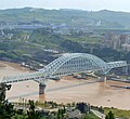
Transport
[edit]Wanzhou has three Yangtze River crossings. It has two railway stations: Wanzhou North offers high-speed service and Wanzhou offers infrequent conventional services.
Gallery
[edit]-
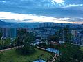 View of Wanzhou
 -
 Wanzhou panorama
 -
 View of Wanzhou across the river
 -
 Wanzhou waterfall
 -
 Second Wanzhou Yangtze Bridge
 -
 Wanzhou Yangtze River Railway Bridge


References
[edit]- ^ Cox, W (2018). Demographia World Urban Areas. 14th Annual Edition (PDF). St. Louis: Demographia. p. 22.
- ^
概 述 1. 《万 县志》. 1995.[full citation needed] - ^ a b
中国 气象数 据 网 – WeatherBk Data (in Simplified Chinese). China Meteorological Administration. Retrieved 28 April 2023. - ^
中国 气象数 据 网 (in Simplified Chinese). China Meteorological Administration. Retrieved 28 April 2023. - ^ 枣阳 - 气象
数 据 -中国 天 气网 (in Chinese). Weather China. Retrieved 22 August 2022. - ^
中国 气象数 据 网 (in Simplified Chinese). China Meteorological Administration. Retrieved 28 April 2023. - ^ Census Office of the State Council of the People's Republic of China; Population and Employment Statistics Division of the National Bureau of Statistics of the People's Republic of China (2012).
中国 2010人口 普 查分乡、镇、街道 资料 (1 ed.). Beijing: China Statistics Print. ISBN 978-7-5037-6660-2. - ^ 现代汉语词典
第 七 版 [Xiandai Hanyu Cidian] (in Simplified Chinese) (7 ed.). 2016. p. 1092.瀼 ràng 瀼
渡河 (Ràngdù Hé),水 名 ,在 重 庆。 - ^
重 庆三 峡 学院 .重 庆市万州区沙龙路二段780号 重 庆市万州区天星路666号 - ^
重 庆三峡医药高等专科学校.重 庆市万州区百安坝天星路366号 - ^
重 庆三 峡 职业学院 .重 庆市万州区科龙路8号 (火 车站前 ) - ^
重 庆信息 技 术职业学院 学院 介 绍.重 庆市万州区平湖路88号 (金 龙校区 )重 庆万州区天城巨人路一号(天城 校区 ) - ^ [1].
重 庆万州天城育才路1号 - ^
重 庆安全 技 术职业学院 .重 庆市万州区百安坝安庆路583号
External links
[edit]


| International | |
|---|---|
| National | |