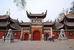
Yunyan District
This article needs additional citations for verification. (March 2014) |
Yunyan
| |
|---|---|
 | |
| Coordinates (Yunyan District government): 26°36′17″N 106°43′28″E / 26.6046°N 106.7244°E | |
| Country | China |
| Province | Guizhou |
| Prefecture-level city | Guiyang |
| Area | |
| • Total | 94 km2 (36 sq mi) |
| Population (2010) | |
| • Total | 957,535 |
| • Density | 10,187/km2 (26,380/sq mi) |
| Time zone | UTC+8 (China Standard) |
Yunyan District (simplified Chinese:
History
[edit]Yunyan belonged to the Shunyuan Military Monitoring Department during the Yuan dynasty, and later the Guizhou Military Monitoring Department during the Ming dynasty.[1] Since Guizhou's establishment as a province during the Ming dynasty, Yunyan has been the seat of the province.[1] In August 1955, Guiyang's first district was renamed to Yunyan District, and its second district was renamed Fushui District. In 1958, Fushui was merged into Yunyan.[1]
Administrative divisions
[edit]Yunyan District comprises 17 subdistricts and 1 town:[2]
- subdistricts
- Dayinglu Subdistrict
大 营路街道 - Qianlingdonglu Subdistrict 黔灵东路
街道 - Wenchangge Subdistrict
文 昌 阁街道 - Yanwujie Subdistrict 盐务
街 街道 - Putuolu Subdistrict
普 陀路街道 - Bageyan Subdistrict
八 鸽岩街道 - Yuxiulu Subdistrict 毓秀
路 街道 - Weiqingmen Subdistrict
威 清 门街道 - Shixihe Subdistrict
市 西河 街道 - Touqiao Subdistrict 头桥
街道 - Sanqiaolu Subdistrict
三 桥路街道 - Mawang Subdistrict 马王
街道 - Jinguan Subdistrict
金 关街道 - Chayuanlu Subdistrict
茶 园路街道 - Yanghui Subdistrict 杨惠
街道 - Yu'an Subdistrict 渔安
街道 - Shuidonglu Subdistrict
水 东路街道
- town
- Qianling Town 黔灵镇
References
[edit]- ^ a b c d e "Yunyan District". Guiyang Official Website. Retrieved 19 November 2020.
- ^ 2023
年 统计用 区 划代码和城 乡划分 代 码:云 岩 区 (in Simplified Chinese). National Bureau of Statistics of China.
External links
[edit]


