(Translated by https://www.hiragana.jp/)
Google Lat Long: Mobile


Whether you're on foot looking for the best sushi place in a new neighborhood or you'd like to do some virtual archaeology around Pompeii, we're all explorers of the world around us in our own way. Your definition of adventure is unique, so we like to offer several ways to explore the world. With the latest edition of Google Earth for ...

Whether you're on foot looking for the best sushi place in a new neighborhood or you'd like to do some virtual archaeology around Pompeii, we're all explorers of the world around us in our own way. Your definition of adventure is unique, so we like to offer several ways to explore the world. With the latest edition of Google Earth for Android or iOS – now available in more than 100 countries – your virtual adventures will be even more amazing and immersive.

 Chicago skyline in 3D in the new interface

Have you ever wanted to take a tour of Stonehenge or retrace the steps of Christopher Columbus? With the addition of Street View to Google Earth for mobile devices, you can explore many sites from street level right on your mobile device. And with the new streamlined interface, a simple click of the Earth logo in top left will give you quick access to more information through layers like Panoramio Photos and Wikipedia. Just in case you decide to visit these places yourself, Google Earth's improved directions enable you to visualize step-by-step transit, walking and biking directions in full 3D.

Stonehenge, Wiltshire, England in Street View

Also with this release, we're making Google Earth for mobile available in more than 100 countries worldwide, so you can start their virtual journey in Google Earth from almost anywhere on Earth. To unleash your inner explorer, check out your local Google Play store or iTunes to download the latest version of Earth for Android and iOS. 


Posted by Haris Ramic, Google Earth product manager


I use public transit to get around my city or to explore new ones when traveling. When on the go, I rely on Google Maps Transit to help me get to my destination using public transportation. We want to make sure you have access to the most comprehensive, accurate and useful information when you’re on the go – and that includes public transportation.

I use public transit to get around my city or to explore new ones when traveling. When on the go, I rely on Google Maps Transit to help me get to my destination using public transportation. We want to make sure you have access to the most comprehensive, accurate and useful information when you’re on the go – and that includes public transportation.

Starting today, you can view live departure times for seven lines on the New York City subway system (MTA), as well as for buses and trams in the greater Salt Lake City area (UTA). With these updates – part of the millions of live transit schedule updates we process every day – you get instant access to the latest information right on Google Maps, making trip planning a cinch.

Get live trip updates on Google Maps 

Riders on the nation’s second largest subway, Metrorail in Washington, D.C., can now see live service alerts, including unplanned delays and scheduled track work, straight from Metro’s Control Center on Google Maps. To adjust your travel around the alerts you see, simply choose another suggested route or change your departure time.

Get service alerts on Google Maps 

With transit information in Google Maps you get pick-up locations, departure times, estimated travel time, and even fare amounts for 800 cities* across more than 25 countries around the world – that’s information for 100 million miles of daily public transit trips at your fingertips.

Download Google Maps on your Android device or iPhone to get public transit information on the go. And if you represent a transit agency that would like to participate in Google Maps, please visit our site for transit agency partners.

Posted by Soufi Esmaeilzadeh, Partnership Development Manager, Google Maps

*Live trip updates are available in select cities.


You just stepped out of the gondola into a strong wind at the peak. It’s cold and you’re weighing whether to drop into that powdery black diamond chute you’ve always dreamt of...or sliding down the nearest blue for hot cider at the base.

You just stepped out of the gondola into a strong wind at the peak. It’s cold and you’re weighing whether to drop into that powdery black diamond chute you’ve always dreamt of...or sliding down the nearest blue for hot cider at the base.

With 38 new run and lift maps for some of the most popular mountains across the US and Canada, Google Maps is your “go to” mountain guide. Whether you’re shredding Squaw Valley, Big Sky, or Okemo, Google Maps are a comprehensive, accurate and easy way to find the best route down the hill.
Power up Google Maps on your Android device or iPhone, and the mountain information you need is right there. Blue, green and black runs are shown as solid colored lines and ski lifts are red dotted lines.


Ski resorts in Google Maps can also be helpful when you’re gearing up for a trip. You can check out the maps on your laptop browser to plot your course, and even get a Street View preview of a few select slopes before you head up the mountain.


Map of Squaw Valley near Lake Tahoe in California

The growing list of mountain maps now available in Google Maps is here:


We hope you’ll use these maps to discover new trails and find your way around the mountain more quickly and easily. We’ve got more ski resort maps on the way, so be sure to check Google Maps before your next trip. See you out there!

(Cross posted to Official Google Blog

We hope you’ve had a chance to try the new Google Maps app for iPhone (announced last week and available for download in the ...
(Cross posted to Official Google Blog

We hope you’ve had a chance to try the new Google Maps app for iPhone (announced last week and available for download in the Apple App Store). The app is designed to be simple—just to work whenever you need it. Still, we have a few tips to make finding things with Google Maps even faster and easier. All the tips are collected on our site but here a few of my favorites:
  • Swipe to see more. In Google Maps a wealth of information is often just a swipe away. Whether you’re looking at search results or directions, you can swipe the bottom info sheet left and right to see other options. To get more details on any of the results, swipe that info sheet upward (or just tap it—that works too). Even with the info sheet expanded, you can swipe to see those other results.
  • Place a pin. Get more information about any location by just pressing and holding the map. The info sheet that pops up tells you the address, lets you save or share the place, and best of all, brings up...
  • Street View. By far the easiest way to get to Street View is placing a pin. Tap the imagery preview on the info sheet to enter into Street View, then explore! I recommend the look-around feature (bottom left button) which changes what you’re looking at as you tilt and move your phone.
Want to learn more? See the rest of our tips on the site. And as you explore the app on your own, share your own tips using #googlemaps. Most of all, enjoy discovering your world.


(Cross posted on Official Google Blog)

People around the world have been asking for Google Maps on iPhone. Starting today, we’re pleased to announce that Google Maps is here—rolling out across the world in the ...
(Cross posted on Official Google Blog)

People around the world have been asking for Google Maps on iPhone. Starting today, we’re pleased to announce that Google Maps is here—rolling out across the world in the Apple App Store. It’s designed from the ground up to combine the comprehensiveness and accuracy of Google Maps with an interface that makes finding what you’re looking for faster and easier.

The app shows more map on screen and turns mobile mapping into one intuitive experience. It’s a sharper looking, vector-based map that loads quickly and provides smooth tilting and rotating of 2D and 3D views. The search box at the top is a good place to start—perhaps by entering the name of a new and interesting restaurant. An expandable info sheet at the bottom shows the address, opening hours, ratings and reviews, images, directions and other information.


At the heart of this app is our constantly improving map of the world that includes detailed information for more than 80 million businesses and points of interest. Preview where you want to go with Street View and see inside places with Business Photos to decide on a table or see if it’s better at the bar. To get you there, you’ve got voice-guided, turn-by-turn navigation, live traffic conditions to avoid the jams and if you want to use public transportation, find information for more than one million public transit stops.


The world around us is constantly changing and, thanks to feedback from you, we make tens of thousands of daily updates to keep Google Maps accurate and comprehensive. Here’s a helpful hint for the new app: if you see something off, simply shake your phone to send us feedback.

To complete the Google Maps ecosystem, we’re also releasing the Google Maps SDK for iOS, and a simple URL scheme to help developers use Google Maps when building their beautiful and innovative apps.

The new Google Maps app is available for the iPhone and iPod Touch (4th gen) iOS 5.1 and higher, in more than 40 countries and 29 languages, including Chinese, Dutch, English, French, German, Italian, Japanese and Spanish. Please note some of the features mentioned in this post aren’t available in all countries.

Visit the App Store today and download the new Google Maps app. We believe this delightful new experience is a great starting point—and we’ll continue to improve Google Maps for you, every day.

(Cross posted from Official Google Blog


These accurate, easy-to-use indoor maps are available for a number of popular retail locations across the globe including many local malls and select Best Buy, Nordstrom, Macy’s, Bloomingdale’s, Harrod’s, Selfridges, John Lewis and other stores. With the help of your Android device, you can beeline it to the camcorder you’ve been eyeing for your dad, and then quickly make your way to that sweater you know your sister will love. For list of additional venue partners, including some in Belgium that just became available today, check out
(Cross posted from Official Google Blog

The holiday shopping season is upon us. Your favorite retail stores are already playing holiday tunes, promoting sales, and decking out their displays in red and green. But if flashbacks of people rushing all around you frantically trying to find gifts for everyone on their lists are giving you anxiety, fret not. This year you can use indoor Google Maps on your Android device to stay cool, calm, collected and most of all, one step ahead of the crowd.

On Black Friday and throughout this holiday season, simply zoom in to a participating store on Google Maps to devise your shopping game plan. An indoor floor plan with helpful labels will automatically appear, and the familiar “blue dot” icon will help you figure out the fastest way to the accessories department, the food court when you need to refuel, and the closest restroom or ATM when you need a break from your marathon shopping session. For many locations, you can even get indoor walking directions to find the best route from one store to the next. 


Indoor Google Maps for Mall of America in Bloomington, MN (left)
and for Macy’s in New York, NY (right)

These accurate, easy-to-use indoor maps are available for a number of popular retail locations across the globe including many local malls and select Best Buy, Nordstrom, Macy’s, Bloomingdale’s, Harrod’s, Selfridges, John Lewis and other stores. With the help of your Android device, you can beeline it to the camcorder you’ve been eyeing for your dad, and then quickly make your way to that sweater you know your sister will love. For list of additional venue partners, including some in Belgium that just became available today, check out this list


Indoor Google Maps for West Edmonton Mall in Edmonton, Alberta, Canada (left) 
and for  Nordstrom in Seattle, WA (right)

We hope these indoor maps make finding your way in and around retail stores easier, less stressful and more efficient this holiday season. To access them, simply update Google Maps on your Android by visiting Google Play on your phone or desktop. Happy holiday shopping!

Posted by Cedric Dupont, Product Manager, Google Maps


To make Google Maps even more comprehensive, accurate and useful, today we’re making Street View available on mobile browsers. With access to Street View on your phone, you can use panoramic, street-level imagery to explore and navigate the places around you, even on the go.

To make Google Maps even more comprehensive, accurate and useful, today we’re making Street View available on mobile browsers. With access to Street View on your phone, you can use panoramic, street-level imagery to explore and navigate the places around you, even on the go.

Times Square, New York
District Wine Bar, San Francisco
Starting today, use Street View on your mobile browser to check out a new shop across town or get a feel for the ambiance at a restaurant before you arrive. To use Street View on your mobile browser simply go to maps.google.com and search for a location. Then click the “pegman” icon at the bottom right of your screen to access Street View. And to view still more helpful imagery, such as a photos shared by users or interior panoramas, visit the business’ Google+ Local page.

Access Street View by clicking on the “pegman” icon
Also, transit, driving, biking and walking directions continue to be available on your mobile browser to help you help guide you to your destination.

For quick access to Google Maps on iOS devices, you can save a bookmark to your home screen. Simply click “Save to Home Screen” on the bottom of the page when you’re in Google Maps, or follow the instructions here.


When you’re on the go, it can be difficult to recall all of the places you’ve searched on your desktop browser at home. To make Google Maps more useful and comprehensive, we added a few improvements to better sync your maps experience across all of your devices. Today, with the latest release of ...

When you’re on the go, it can be difficult to recall all of the places you’ve searched on your desktop browser at home. To make Google Maps more useful and comprehensive, we added a few improvements to better sync your maps experience across all of your devices. Today, with the latest release of Google Maps for Android, we’re making it faster and easier for you to get the information you’ve searched for on your browser, right on your Android phone.

Just make sure you’re signed in to Google Maps and your web history is enabled to get a number of new benefits including search and directions history. When you start to type a place or directions into the search box on your Android device, you’ll see suggestions for directions and locations that you’ve previously searched for – making it easier to quickly find directions on the go.

Desktop and Mobile search synchronisation.

You can also see your mapping search history, as well as your directions history, on your Android phone by going to the “Search” or “Directions” tab under My Places. This way, places and businesses you have already searched for will show up in your suggestions to save you time when you’re out and about.


Access your search history under My Places.

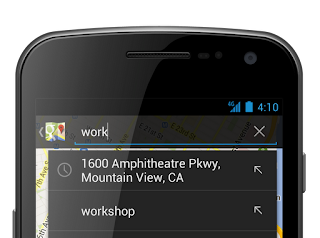
Also, as in previous versions of Google Maps for Android, when you chose to set locations such as “home” and “work", you can quickly access directions to these places by simply typing “home” or “work” in the search field on your mobile device.
       
Searching for work automatically suggests your work address.

We’re always working to make your Google Maps experience more comprehensive, accurate and useful across all devices. To learn more about these features you can visit our site.

Posted by Keiji Maekawa, Software Engineer, Google Maps


Maps keep our spirit of adventure alive by making it easier for us to explore the world around us. That’s why today, we’re making Google Maps even better with new turn-by-turn navigation with traffic conditions, biking directions, Map Maker and new Street View imagery in more locations globally. These improvements are part of our ongoing effort to build the best map we can -- one that’s comprehensive, accurate and easy for you to use.

Maps keep our spirit of adventure alive by making it easier for us to explore the world around us. That’s why today, we’re making Google Maps even better with new turn-by-turn navigation with traffic conditions, biking directions, Map Maker and new Street View imagery in more locations globally. These improvements are part of our ongoing effort to build the best map we can -- one that’s comprehensive, accurate and easy for you to use.

First, we’re expanding Google Maps Navigation (Beta) with voice guided, turn-by-turn directions in thousands of towns across India. Navigation is one of the most frequently requested features in this region and can be especially helpful when driving in densely populated cities like Delhi or Bangalore. We’re also adding live traffic conditions for major roads with estimated travel times to help you save time and to reduce stress on the road.

Turn-by-turn voice navigation in New Delhi, India

Biking directions and Map Maker are also now rolling out to New Zealanders. Local cyclists can access biking directions directly on Google Maps, and use Map Maker to add bike lanes and trails if their favorite route is missing or they discover a new one. Beyond biking trails, Map Maker can also be used to make the New Zealand map more accurate with details such as new road names, building footprints and more.

Biking directions from Remuera in Auckland to the local Google office

Later today, we’ll also release new Street View imagery for more than 150 university campuses globally. With classes just getting started, freshman students, transfers and even empty-nesting parents can now familiarize themselves with college campuses around the world, including UCLA in the U.S., Pembroke College in the U.K., McGill University in Canada and Sophia University in Japan. These new panoramic views join our growing list of universities whose campuses are already available in Google Maps.


View Larger Map
Royce Hall at the University of California, Los Angeles

Finally, to celebrate all the places you can reach with Google Maps—all seven continents, the sky, the moon and even the depths of the ocean—we made a video that we hope will inspire you to keep exploring.


Keep exploring at maps.google.com/helloworld. Here’s to many new adventures.


(Cross-posted on the Official Google Blog)

Whether you’re a seasoned century rider or a casual beach cruiser, finding the best biking routes can be a challenge. That’s why today we’re bringing mobile biking directions and navigation to the 10 countries where we launched desktop biking directions last month (Australia, Austria, Belgium, Denmark, Finland, the Netherlands, Norway, Sweden, Switzerland and the UK). Plus, we’re adding turn-by-turn, voice-guided biking navigation to Google Maps Navigation (beta) in every country with biking directions. Mount your device on your handlebars to see the turn-by-turn directions and navigation, or use speaker-mode to hear voice-guided directions.

Turn-by-turn biking navigation in Copenhagen


We know there are lots of ways to get from here to there, which is why in 2010 we added biking directions to Google Maps in the U.S. and Canada, and continue to work to bring more biking features to more places. Today, there are more than 330,000 miles (equal to more than 530,000 kilometers, or half a gigameter) of green biking lines in Google Maps. Dark green lines on the map show dedicated bike trails and paths with no motor vehicles, light green lines show streets with bike lanes and dashed green lines show other streets recommended for cycling. Biking navigation even helps you avoid steep hills.

Bike layer showing recommended streets for cycling in Stockholm


Where Map Maker and biking directions are both available, riders can add bike trails, lanes and suggested routes to Google Maps, helping to create a more comprehensive map for everyone living in or visiting their community. Thanks to the contributions of members of the biking community like Todd Scott and our partnership with nonprofits like Rails-to-Trails Conservancy, we’ve added bike data for hundreds of cities and trails to Google Maps in the past two-and-a-half years.

When you’re pedaling from Point A to Point B, we hope biking navigation will make Google Maps for Android more useful to you.


Posted by Larry Powelson, Software Engineer, Google Maps


Today, we’re happy to announce the availability of 3D imagery for Google Earth on the new iPad, iPad 2 and iPhone 4S.

A map must be comprehensive and accurate no matter where you are or what device you use. We also believe maps can be useful in ways you might not have imagined. With today’s release of Google Earth for iOS you can literally fly through breathtaking ...

Today, we’re happy to announce the availability of 3D imagery for Google Earth on the new iPad, iPad 2 and iPhone 4S.

A map must be comprehensive and accurate no matter where you are or what device you use. We also believe maps can be useful in ways you might not have imagined. With today’s release of Google Earth for iOS you can literally fly through breathtaking 3D city landscapes and images and follow virtual tours of places you’ve never been -- all with a simple swipe of your fingertip. It’s a new, and I think magical way to explore the world in which we live.

The growing list of 3D cities include Boulder, Boston, Charlotte, Lawrence (Kan.), Long Beach (Ca.), Los Angeles, Portland (Ore.), San Diego, Santa Cruz, Tampa, Tucson, and the San Francisco Bay Area (including the Peninsula and East Bay) as well as Rome, Italy. We’ll keep building and releasing 3D imagery for new locations as fast as we can and by the end of the year we aim to have coverage for metropolitan areas with a combined population of 300 million people.


Also new in this release is a “tour guide” to show you interesting places to explore. We’ve put together short tours of thousands of famous places and historical sites across the globe so it’s easier than ever to discover amazing places. Just pull up the tab at the bottom of the screen to open the tour guide. Each image highlights a tours or place of interest in the area you are looking. Click on an item and you will be flown there. As you fly in and around the sites, snippets from Wikipedia provide additional information about the location. It’s like having a local expert right beside you! The tour guide is available for all iOS devices running iOS 4.2 and newer.

To start exploring, download the latest version of Google Earth for iPhone, iPad, and iPod touch from the Apple App Store today.


Back in 2009 we released My Tracks, an Android app that uses your phone’s GPS capabilities to visualize your location over time for sharing in Google Maps and Google Earth ...

Back in 2009 we released My Tracks, an Android app that uses your phone’s GPS capabilities to visualize your location over time for sharing in Google Maps and Google Earth.

We’ve used My Tracks to follow team HTC-Columbia during the Tour de France and trace the paths of our skiing adventures. A year after launch we open sourced the software and released the code to the world for developers to use in their own applications. Now, we’re happy to announce that My Tracks 2.0 is available for download on Google Play.

Trace your path with My Tracks 2.0

My Tracks 2.0 comes with a variety of new features, including:
  • The ability to play back your tour directly on Google Earth for Android
  • Aggregation of statistics over time to show trends in your performance
  • Simpler, faster user interface
  • Improved charts and stats tables that are easier to read
Update to My Tracks 2.0 today and start tracing and sharing your path around the world.


This week we announced new 3D imagery on Google Earth for Android for a select number of initial cities, including San Francisco, Los Angeles and Rome. Along with the availability of more comprehensive and realistic 3D imagery, we’ve also included a new ...

This week we announced new 3D imagery on Google Earth for Android for a select number of initial cities, including San Francisco, Los Angeles and Rome. Along with the availability of more comprehensive and realistic 3D imagery, we’ve also included a new tour guide feature in this latest release. Taking a virtual trip to places such as Stonehenge in England, Brandenburg Gate in Germany, or the Great Wall of China has always been possible by typing a location into Google Earth; but how do you know where in the world you’d like to visit if you are not familiar with an area?

The new tour guide allows you to discover and explore interesting places around the world, even if you didn’t know to search for them. It is already available on Google Earth for Android, and an update to Google Earth for iOS will be coming soon. We invite you to embark on any of the more than 11,000 tours of popular sites in over 110 countries and regions, from famous landmarks to scenic treasures. You can open the tour guide with a quick swipe of the tab located on the bottom of the main Google Earth screen.

Open a list of tour thumbnails by swiping the tab located at the bottom of the Google Earth for mobile screen

Thumbnails of available pre-created tours will dynamically update with interesting locations in your current view. Simply click the thumbnail image to start the tour and begin your online adventure of discovering new and exciting places around the world.

Tour of the Transamerica Pyramid in San Francisco, California

Where available, the tours include 3D models for the most realistic experience possible. Information from Wikipedia also provides more information on famous sites, so you can learn more about the places that interest you as your virtually fly over them. The tour guide also includes user-contributed Picasa and Panoramio photos as thumbnails for a preview of the featured location.

To get started, update Google Earth on your mobile device. Happy touring!


Explorers of the world, rejoice! There is now a new way to explore the world, right from the palm of your hand. Gone are the days when the only way to get a bird’s eye, 3D view of your favorite metropolitan area was from the window of a penthouse apartment or helicopter. Now you can soar above your favorite cities in 3D, with ...

Explorers of the world, rejoice! There is now a new way to explore the world, right from the palm of your hand. Gone are the days when the only way to get a bird’s eye, 3D view of your favorite metropolitan area was from the window of a penthouse apartment or helicopter. Now you can soar above your favorite cities in 3D, with Google Earth for mobile.


New 3D Imagery
We recently shared a preview of this striking new 3D imagery and starting today, you can take flight yourself with our latest version of Google Earth for Android. An updated version of Google Earth for iOS will be also be available soon.


New 3D imagery of Portland, Oregon

Creating this comprehensive 3D experience is possible due to advanced image processing. Using 45-degree aerial imagery, we're able to automatically recreate entire metropolitan areas in 3D. This means every building (not just the famous landmarks), the terrain, and any surrounding landscape of trees are included to provide a much more accurate and realistic experience.

Get started today by taking a virtual flight over one of our initial 3D imagery cities: Boulder, Boston, Santa Cruz, San Diego, Los Angeles, Long Beach, San Antonio, Charlotte, Tucson, Lawrence, Portland, Tampa, Rome or the San Francisco Bay Area (including the Peninsula and East Bay). We’ll continue to release new 3D imagery for places around the world over the coming months; by the end of the year, we aim to have new 3D coverage for metropolitan areas with a combined population of 300 million people.

Tour Guide
Not sure where to begin? Let the new tour guide help show you the way. We’ve put together short tours of thousands of famous places and historical sites across the globe so it’s easier than ever to discover amazing places. Just pull up the tab at the bottom of the screen to open the tour guide. Each image highlights a tours or place of interest in the area you are looking. Click on an item and you will be flown there. As you fly in and around the sites, snippets from Wikipedia provide additional information about the location. It’s like having a local expert right beside you!


Tour guide showing top destinations around Los Angeles.

We hope this more accurate, comprehensive and realistic 3D representation of the Earth brings out the inner explorer in you. Whether you are visiting familiar grounds or venturing out into the world, Google Earth is there to show you the way.


Having an Internet connection has always been a key requirement for using Google Maps for Android... until now.

A few weeks ago we told you that offline Google Maps for Android was coming. Now, you can download the latest version of the app in Google Play, then select and save a region of a map from more than 150 countries for use offline. Whether travelling internationally, carrying a WiFi-only device, heading underground on the subway or restricting your mobile data usage, you can now save up to six large metro areas (e.g., Greater London, Paris, or New York City and surrounding area) and use Google Maps for Android to find your way.


Let’s say you find yourself traveling to London this summer. Before you head off on your trip, simply find the area that you’ll be visiting. Then select “Make available offline” from the menu and verify the area that you would like to save. 

Below the map, you’ll see we estimate the file size for you, so you know how much space it will take on your device. Once you confirm your selection the map will immediately start downloading.

Save an area and go to My Places to see all your offline maps
If you have GPS enabled on the device, the blue dot will still work without a data connection so you know where you are, and if your device has a compass you can orient yourself without 3G or WiFi connectivity.  

So whether you’re traveling internationally or underground, we hope offline maps will help you get around. 

Today we’re also releasing a smoother and faster Compass Mode for Street View within Google Maps for Android. It’s the next best thing to being there, because your device becomes a window into a 360-degree, panoramic view of the outdoor or interior location through Business Photos. To experience the improved qualities of this feature you need a device with Google Maps for Android, Android 3.0 or higher and a gyroscope sensor plus version 1.8.1 of Street View on Google Maps.

See inside District wine bar in San Francisco
To learn more about Google Maps for Android features, start here

Posted by Jiabei Lei, Software Engineer, Google Maps Mobile


Google Maps has expanded live traffic coverage to include 7 new regions in 7 new countries including Belarus, Estonia, Latvia, Mexico, Peru, Romania and South Africa.

Google Maps has expanded live traffic coverage to include 7 new regions in 7 new countries including Belarus, Estonia, Latvia, Mexico, Peru, Romania and South Africa.


The traffic data allows you to see current traffic conditions, and also gives you estimated travel times.

Aside from these new additions, we have also improved and expanded our coverage to more roads in 19 countries and regions, where traffic data is already available; the countries include: Australia, Belgium, Brazil, Denmark, Finland, France, Germany, Israel, Italy, Japan, Netherlands, New Zealand, Puerto Rico, Russia, Spain, Sweden, Taiwan, and the UK.


A quick glance at our traffic coverage around the globe

For our new users, you can check traffic conditions by visiting maps.google.com and clicking on the traffic layer in the widget on the upper right-hand side of the map. This useful traffic information is also available on Google Maps for Mobile devices and Google Maps Navigation.

If the roads you are traveling do not yet show traffic information, don’t despair. You can help your fellow drivers and improve traffic data by using Google Navigation or Google Maps for Mobile while traveling.

We hope the traffic feature in Google Maps will help more users around the globe to save time and patience by planning their trips accordingly.

(Cross posted from the Official Google Blog)

For the last decade we’ve obsessed over building great maps for our users—maps that are totally comprehensive (we’re shooting for literally the whole world), ever more accurate and incredibly easy to navigate.
(Cross posted from the Official Google Blog)

For the last decade we’ve obsessed over building great maps for our users—maps that are totally comprehensive (we’re shooting for literally the whole world), ever more accurate and incredibly easy to navigate.

Comprehensiveness

It’s a pretty limited search engine that only draws from a subset of sources. In the same way, it’s not much of a map that leaves you stranded the moment you step off the highway or visit a new country. Over the last few years we’ve been building a comprehensive base map of the entire globe—based on public and commercial data, imagery from every level (satellite, aerial and street level) and the collective knowledge of our millions of users.

Today, we’re taking another step forward with our Street View Trekker. You’ve seen our cars, trikes, snowmobiles and trolleys—but wheels only get you so far. There’s a whole wilderness out there that is only accessible by foot. Trekker solves that problem by enabling us to photograph beautiful places such as the Grand Canyon so anyone can explore them. All the equipment fits in this one backpack, and we’ve already taken it out on the slopes.

Luc Vincent, engineering director, taking the Street View Trekker for a trial run in Tahoe

Accuracy

The next attribute map makers obsess over is accuracy. We still have a way to go because the world is constantly changing—with new houses, cities and parks appearing all the time—it’s a never ending job. But by cross-checking the data we have, we can significantly improve the accuracy of our maps. Turns out our users are as passionate about the quality of Google Maps as we are, and they give us great feedback on where we can do better. We make thousands of edits a day based on user feedback through our Report a Problem tool and via Map Maker, which we launched in 2008. Today we’re announcing the expansion of Map Maker to South Africa and Egypt, and to 10 more countries in the next few weeks: Australia, Austria, Belgium, Denmark, Finland, Liechtenstein, Luxembourg, New Zealand, Norway and Switzerland.

Usability

The final element of the perfect map is usability. It’s hard to remember what digital maps were like before Google Maps went live in 2005, and the huge technological breakthroughs that transformed clicking on arrows and waiting, to simply dragging a map with a mouse and watching it render smoothly and quickly. Plus, we added one single search box. Today we have thousands of data sources that feed into our maps making them a rich and interactive experience on any device—from driving directions to transit and indoor maps to restaurant reviews.

People have been asking for the ability to use our maps offline on their mobile phones. So today we’re announcing that offline Google Maps for Android are coming in the next few weeks. Users will be able to take maps offline from more than 100 countries. This means that the next time you are on the subway, or don’t have a data connection, you can still use our maps.

The next dimension

An important next step in improving all of these areas—comprehensiveness, accuracy, and usability of our maps—is the ability to model the world in 3D. Since 2006, we’ve had textured 3D buildings in Google Earth, and today we are excited to announce that we will begin adding 3D models to entire metropolitan areas to Google Earth on mobile devices. This is possible thanks to a combination of our new imagery rendering techniques and computer vision that let us automatically create 3D cityscapes, complete with buildings, terrain and even landscaping, from 45-degree aerial imagery. By the end of the year we aim to have 3D coverage for metropolitan areas with a combined population of 300 million people.


I have been working on mapping technology most of my life. We’ve made more progress, more quickly as an industry than I ever imagined possible. And we expect innovation to speed-up even more over the next few years. While we may never create the perfect map … we’re going to get much, much closer than we are today.


Wherever you are, Google Maps for Android helps you get around and discover new places. Today with the 6.7 release we will help you find offers from nearby businesses in the U.S. -- everything from restaurants, to salons, to city tours. Also, we’ve added indoor walking directions in the U.S. and Japan, plus 360-degree interior photos of businesses, to help you intrepidly make your way indoors and out.
(Cross-posted on the Official Google Mobile Blog)

Wherever you are, Google Maps for Android helps you get around and discover new places. Today with the 6.7 release we will help you find offers from nearby businesses in the U.S. -- everything from restaurants, to salons, to city tours. Also, we’ve added indoor walking directions in the U.S. and Japan, plus 360-degree interior photos of businesses, to help you intrepidly make your way indoors and out.

Discover great offers near you

Today, in the U.S. only, we’re launching a way to discover nearby Google Offers in Google Maps for Android. To see great deals near you, tap on “Maps” to open the dropdown menu and then tap on “Offers.” If you see something you like you can click on it to learn more. Some Google Offers can be purchased and saved for later while others are immediately available for free. With free Google Offers, press “Use now” to redeem instantly or “Save for later” for future use. You can also opt-in to receive notifications in the app when there are offers near you.


Explore the great indoors with walking directions and Business Photos.

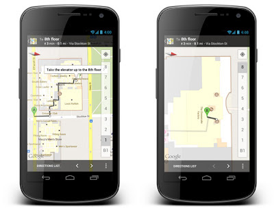
Since we launched indoor maps in the U.S. and Japan in Google Maps for Android last November, business owners have been adding their floor plans to our maps with Google Maps Floor Plans. Today, we are launching indoor walking directions for participating venues in these countries. This will help you get directions not only to a building’s front door, but also through those doors to the places where you want to go inside.

Indoor walking directions
Get Indoor walking directions in indoor maps (photo: Macy’s San Francisco)

With Google Business Photos you can explore panoramic photos of the inside of a business from the palm of your hand. Now you can get a feel for a restaurant or store inside as well as outside using Street View technologies. To access these 360-degree panoramic views, look for the “See Inside” section on the Place page of select businesses.

Business Photos
See the interior of participating businesses with Business Photos (photo: Toyjoy)

Download Google Maps 6.7 for Android from Google Play, and use it as your trusted guide to help you find and discover places to eat, shop and play! You can also learn more about other great features on the Google Maps YouTube channel.