Ottobiano
Jump to navigation
Jump to search
Ottobiano | |
|---|---|
| Comune di Ottobiano | |
Location of Ottobiano  | |
 Ottobiano Location of Ottobiano in Italy  Ottobiano Ottobiano (Lombardy) | |
| Coordinates: 45°9′N 8°50′E / 45.150°N 8.833°E | |
| Country | Italy |
| Region | Lombardy |
| Province | Province of Pavia (PV) |
| Area | |
| • Total | 24.5 km2 (9.5 sq mi) |
| Population (Dec. 2004)[2] | |
| • Total | 1,168 |
| • Density | 48/km2 (120/sq mi) |
| Time zone | UTC+1 (CET) |
| • Summer (DST) | UTC+2 (CEST) |
| Postal code | 27030 |
| Dialing code | 0384 |
Ottobiano is a comune (municipality) in the Province of Pavia in the Italian region Lombardy, located about 45 km (28 mi) southwest of Milan and about 25 km (16 mi) west of Pavia. As of 31 December 2004, it had a population of 1,168 and an area of 24.5 km2 (9.5 sq mi).[3]
Ottobiano borders the following municipalities: Ferrera Erbognone, Lomello, San Giorgio di Lomellina, Tromello, Valeggio.
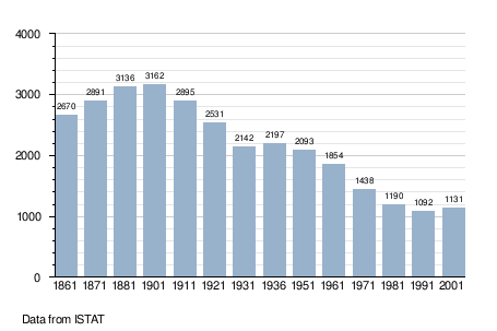
Demographic evolution
Notable people
- Victorio Codovilla (1894–1970), communist politician
References
- ^ "Superficie di Comuni Province e Regioni italiane al 9 ottobre 2011". Italian National Institute of Statistics. Retrieved 16 March 2019.
- ^ "Popolazione Residente al 1° Gennaio 2018". Italian National Institute of Statistics. Retrieved 16 March 2019.
- ^ All demographics and other statistics: Italian statistical institute Istat.
This article on a location in the Province of Pavia is a stub. You can help Wikipedia by expanding it. |
Categories:
- Pages using gadget WikiMiniAtlas
- Pages using the EasyTimeline extension
- Articles with short description
- Short description is different from Wikidata
- Articles containing Italian-language text
- Coordinates on Wikidata
- Pages using infobox settlement with image map1 but not image map
- Cities and towns in Lombardy
- Municipalities of the Province of Pavia
- All stub articles
- Province of Pavia geography stubs
- Pages using the Kartographer extension